Stillwater Topo Map Nevada
To zoom in, hover over the map of Stillwater
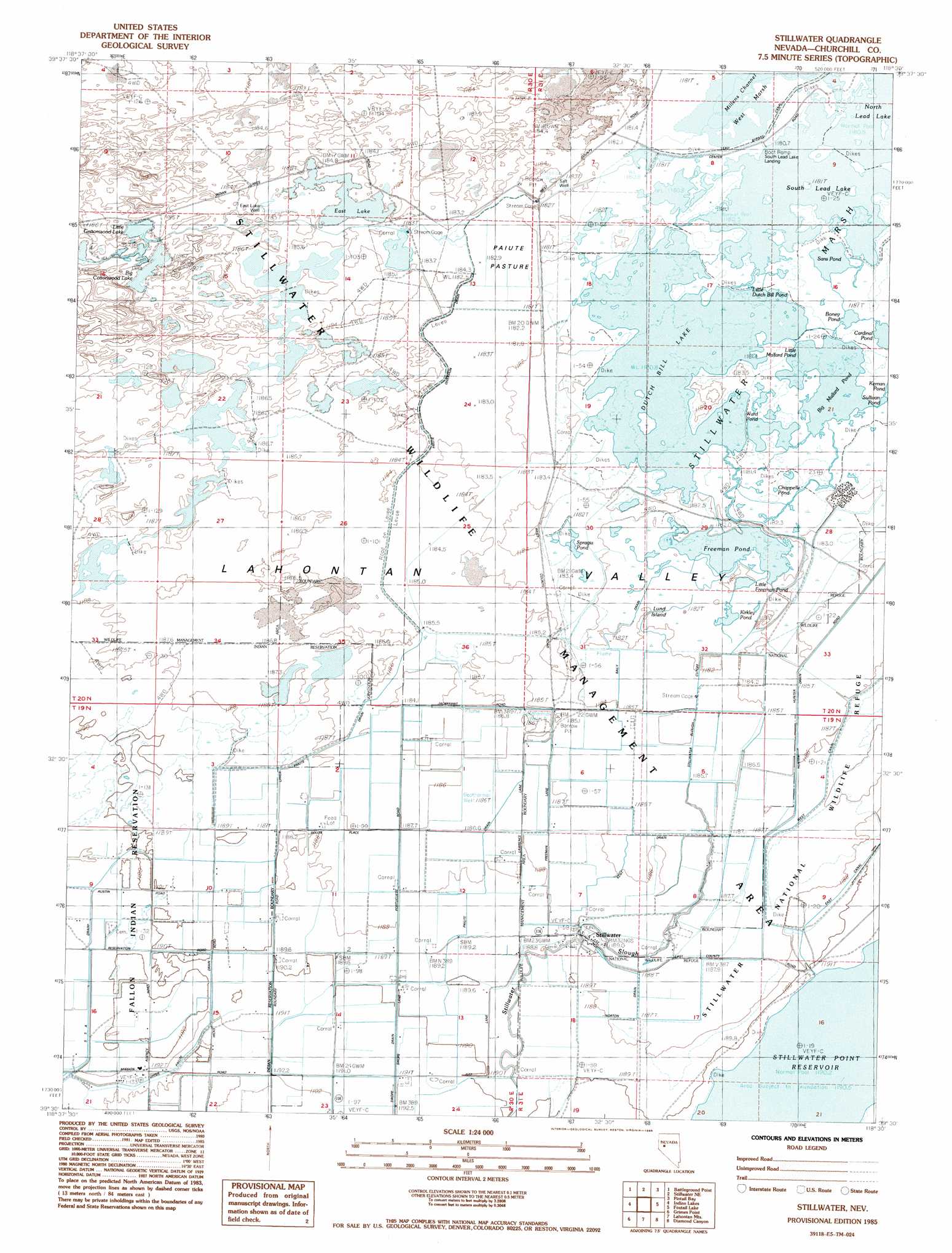
USGS Topo Quad 39118e5 - 1:24,000 scale
| Topo Map Name: | Stillwater |
| USGS Topo Quad ID: | 39118e5 |
| Print Size: | ca. 21 1/4" wide x 27" high |
| Southeast Coordinates: | 39.5° N latitude / 118.5° W longitude |
| Map Center Coordinates: | 39.5625° N latitude / 118.5625° W longitude |
| U.S. State: | NV |
| Filename: | o39118e5.jpg |
| Download Map JPG Image: | Stillwater topo map 1:24,000 scale |
| Map Type: | Topographic |
| Topo Series: | 7.5´ |
| Map Scale: | 1:24,000 |
| Source of Map Images: | United States Geological Survey (USGS) |
| Alternate Map Versions: |
Stillwater NV 1985, updated 1985 Download PDF Buy paper map Stillwater NV 2011 Download PDF Buy paper map Stillwater NV 2015 Download PDF Buy paper map |
1:24,000 Topo Quads surrounding Stillwater
Parran |
Carson Sink Sw |
Carson Sink Se |
Lone Rock Sw |
Lone Rock Se |
Upsal Hogback |
Battleground Point |
Stillwater Ne |
Pintail Bay |
Cox Canyon |
Soda Lake East |
Indian Lakes |
Stillwater |
Foxtail Lake |
Table Mountain |
Fallon |
Grimes Point |
Lahontan Mountains |
Diamond Canyon |
La Plata Canyon |
South Of Fallon |
Carson Lake |
Bunejug Mountains |
Fourmile Flat |
Frenchman |
> Back to 39118e1 at 1:100,000 scale
> Back to 39118a1 at 1:250,000 scale
> Back to U.S. Topo Maps home
Stillwater topo map: Gazetteer
Stillwater: Canals
Baily Drain elevation 1185m 3887′Kent Drain elevation 1187m 3894′
Kent Lake Drain elevation 1187m 3894′
Lead Bypass Canal elevation 1183m 3881′
Norton Drain elevation 1189m 3900′
Paiute Diversion Drain elevation 1185m 3887′
Paiute Drain elevation 1188m 3897′
Patrick Drain elevation 1187m 3894′
S 2 Canal elevation 1187m 3894′
S 5 A Drain elevation 1193m 3914′
Stillwater Slough Cutoff elevation 1185m 3887′
Swope Drain elevation 1193m 3914′
Upper Paiute Number Two elevation 1191m 3907′
Stillwater: Flats
Paiute Pasture elevation 1183m 3881′Stillwater: Islands
Lund Island elevation 1185m 3887′Welch Island elevation 1183m 3881′
Stillwater: Lakes
Big Cottonwood Lake elevation 1186m 3891′Big Mallard Pond elevation 1182m 3877′
Boney Pond elevation 1182m 3877′
Cardinal Pond elevation 1182m 3877′
Chappelle Pond elevation 1183m 3881′
Dutch Bill Lake elevation 1182m 3877′
East Lake elevation 1185m 3887′
Freeman Pond elevation 1184m 3884′
Kerman Pond elevation 1182m 3877′
Kirkley Pond elevation 1184m 3884′
Lead Lake elevation 1182m 3877′
Little Cottonwood Lake elevation 1187m 3894′
Little Dutch Bill Pond elevation 1182m 3877′
Little Freeman Pond elevation 1184m 3884′
Little Mallard Pond elevation 1182m 3877′
Sans Pond elevation 1183m 3881′
Spragia Pond elevation 1184m 3884′
Sullivan Pond elevation 1183m 3881′
Ward Pond elevation 1183m 3881′
Stillwater: Populated Places
Stillwater elevation 1189m 3900′Stillwater: Post Offices
Stillwater Post Office (historical) elevation 1189m 3900′Stillwater: Streams
Stillwater Slough elevation 1184m 3884′Stillwater: Wells
East Lake Well elevation 1185m 3887′Salt Well elevation 1183m 3881′
Stillwater digital topo map on disk
Buy this Stillwater topo map showing relief, roads, GPS coordinates and other geographical features, as a high-resolution digital map file on DVD: