Dayton Topo Map Nevada
To zoom in, hover over the map of Dayton
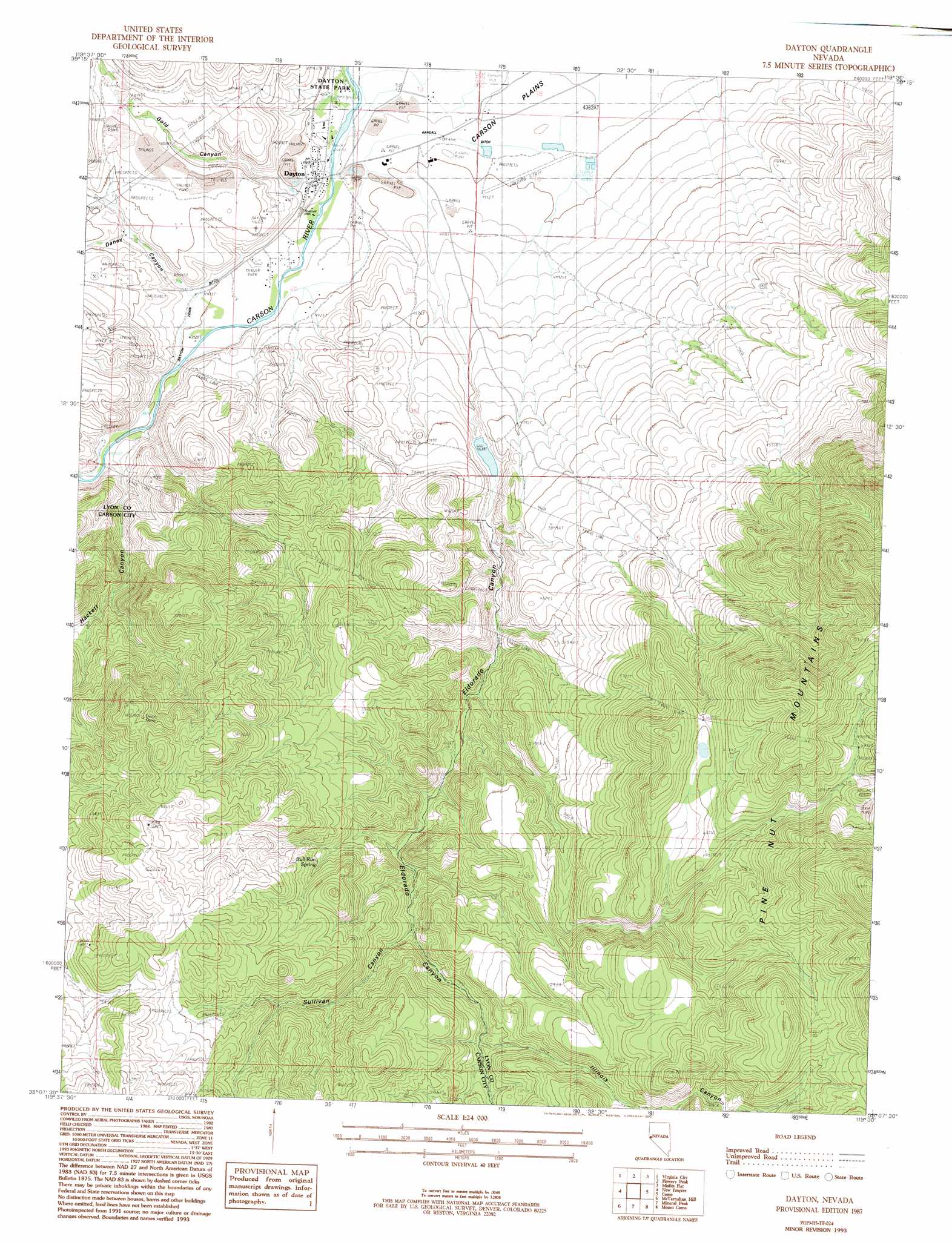
USGS Topo Quad 39119b5 - 1:24,000 scale
| Topo Map Name: | Dayton |
| USGS Topo Quad ID: | 39119b5 |
| Print Size: | ca. 21 1/4" wide x 27" high |
| Southeast Coordinates: | 39.125° N latitude / 119.5° W longitude |
| Map Center Coordinates: | 39.1875° N latitude / 119.5625° W longitude |
| U.S. State: | NV |
| Filename: | o39119b5.jpg |
| Download Map JPG Image: | Dayton topo map 1:24,000 scale |
| Map Type: | Topographic |
| Topo Series: | 7.5´ |
| Map Scale: | 1:24,000 |
| Source of Map Images: | United States Geological Survey (USGS) |
| Alternate Map Versions: |
Dayton NV 1987, updated 1988 Download PDF Buy paper map Dayton NV 1993, updated 1993 Download PDF Buy paper map Dayton NV 2011 Download PDF Buy paper map Dayton NV 2014 Download PDF Buy paper map |
1:24,000 Topo Quads surrounding Dayton
Mount Rose Ne |
Steamboat |
Chalk Hills |
Martin Canyon |
Stockton Well |
Washoe City |
Virginia City |
Flowery Peak |
Misfits Flat |
Churchill Butte |
Carson City |
New Empire |
Dayton |
Como |
Churchill Canyon Well |
Genoa |
Mctarnahan Hill |
Mineral Peak |
Mount Como |
Lincoln Flat |
Minden |
Gardnerville |
Mount Siegel |
Pine Nut Valley |
Artesia Lake |
> Back to 39119a1 at 1:100,000 scale
> Back to 39118a1 at 1:250,000 scale
> Back to U.S. Topo Maps home
Dayton topo map: Gazetteer
Dayton: Airports
Dayton Valley Airpark elevation 1339m 4393′Dayton: Canals
Dayton Town Ditch elevation 1355m 4445′Randall Ditch elevation 1334m 4376′
Dayton: Dams
Eldorado Canyon Dam elevation 1458m 4783′Dayton: Mines
Dayton Placer Mine elevation 1329m 4360′Dixon Mine elevation 1834m 6017′
Eldorado Canyon Quarry elevation 1432m 4698′
Hulley-Logan Mine elevation 1999m 6558′
Dayton: Parks
Dayton State Park elevation 1329m 4360′Dayton: Populated Places
Dayton elevation 1340m 4396′Fiddlers Green elevation 1898m 6227′
Dayton: Post Offices
Dayton Post Office elevation 1340m 4396′Mineral Rapids Post Office (historical) elevation 1330m 4363′
Dayton: Reservoirs
Eldorado Canyon Reservoir elevation 1458m 4783′Dayton: Springs
Bull Run Spring elevation 1743m 5718′Dayton: Streams
Gold Creek elevation 1330m 4363′Dayton: Valleys
Daney Canyon elevation 1365m 4478′Eldorado Canyon elevation 1341m 4399′
Gold Canyon elevation 1364m 4475′
Illinois Canyon elevation 1670m 5479′
Sullivan Canyon elevation 1639m 5377′
Dayton digital topo map on disk
Buy this Dayton topo map showing relief, roads, GPS coordinates and other geographical features, as a high-resolution digital map file on DVD: