New Empire Topo Map Nevada
To zoom in, hover over the map of New Empire
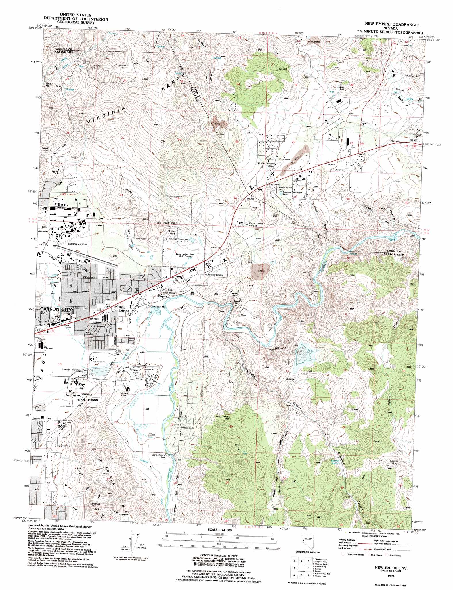
USGS Topo Quad 39119b6 - 1:24,000 scale
| Topo Map Name: | New Empire |
| USGS Topo Quad ID: | 39119b6 |
| Print Size: | ca. 21 1/4" wide x 27" high |
| Southeast Coordinates: | 39.125° N latitude / 119.625° W longitude |
| Map Center Coordinates: | 39.1875° N latitude / 119.6875° W longitude |
| U.S. State: | NV |
| Filename: | o39119b6.jpg |
| Download Map JPG Image: | New Empire topo map 1:24,000 scale |
| Map Type: | Topographic |
| Topo Series: | 7.5´ |
| Map Scale: | 1:24,000 |
| Source of Map Images: | United States Geological Survey (USGS) |
| Alternate Map Versions: |
New Empire NV 1968, updated 1971 Download PDF Buy paper map New Empire NV 1968, updated 1976 Download PDF Buy paper map New Empire NV 1968, updated 1983 Download PDF Buy paper map New Empire NV 1974, updated 1977 Download PDF Buy paper map New Empire NV 1994, updated 1994 Download PDF Buy paper map New Empire NV 1994, updated 1994 Download PDF Buy paper map New Empire NV 2011 Download PDF Buy paper map New Empire NV 2014 Download PDF Buy paper map |
1:24,000 Topo Quads surrounding New Empire
Mount Rose Nw |
Mount Rose Ne |
Steamboat |
Chalk Hills |
Martin Canyon |
Mount Rose |
Washoe City |
Virginia City |
Flowery Peak |
Misfits Flat |
Marlette Lake |
Carson City |
New Empire |
Dayton |
Como |
Glenbrook |
Genoa |
Mctarnahan Hill |
Mineral Peak |
Mount Como |
South Lake Tahoe |
Minden |
Gardnerville |
Mount Siegel |
Pine Nut Valley |
> Back to 39119a1 at 1:100,000 scale
> Back to 39118a1 at 1:250,000 scale
> Back to U.S. Topo Maps home
New Empire topo map: Gazetteer
New Empire: Airports
Carson Airport elevation 1432m 4698′Parker Carson Stolport elevation 1504m 4934′
New Empire: Canals
Mexican Ditch elevation 1410m 4625′New Empire: Mines
Amazon Mine elevation 1580m 5183′Bessemer Mine elevation 1648m 5406′
Bidwell Mine elevation 1782m 5846′
Cinderlite Mine elevation 1855m 6085′
Comstock Extension Mine elevation 1788m 5866′
Dana Mine elevation 1412m 4632′
Daney Mine elevation 1417m 4648′
Eureka Canyon Quarry elevation 1423m 4668′
Mound House Mine elevation 1698m 5570′
Prison Hill Mine elevation 1450m 4757′
Prison Stone Quarry elevation 1439m 4721′
New Empire: Parks
Camp Carson Park elevation 1408m 4619′Centennial Park elevation 1437m 4714′
Terrace Park elevation 1420m 4658′
New Empire: Plains
Ten Mile Desert elevation 1452m 4763′New Empire: Populated Places
Brunswick (historical) elevation 1395m 4576′Empire elevation 1408m 4619′
Eureka (historical) elevation 1372m 4501′
Mound House elevation 1516m 4973′
New Empire elevation 1414m 4639′
Pinyon Hills elevation 1432m 4698′
New Empire: Post Offices
Airport Station Branch Post Office elevation 1415m 4642′Empire Post Office (historical) elevation 1408m 4619′
Mound House Post Office (historical) elevation 1516m 4973′
New Empire: Ridges
Prison Hill elevation 1707m 5600′New Empire: Springs
Badger Spring elevation 1619m 5311′Currys Warm Springs elevation 1428m 4685′
Devil Springs elevation 1442m 4730′
New Empire: Valleys
Brunswick Canyon elevation 1408m 4619′Eureka Canyon elevation 1364m 4475′
Hackett Canyon elevation 1534m 5032′
Lenihan Canyon elevation 1606m 5269′
Sand Canyon elevation 1513m 4963′
Santiago Canyon elevation 1361m 4465′
Spring Valley elevation 1411m 4629′
New Empire digital topo map on disk
Buy this New Empire topo map showing relief, roads, GPS coordinates and other geographical features, as a high-resolution digital map file on DVD: