Flowery Peak Topo Map Nevada
To zoom in, hover over the map of Flowery Peak
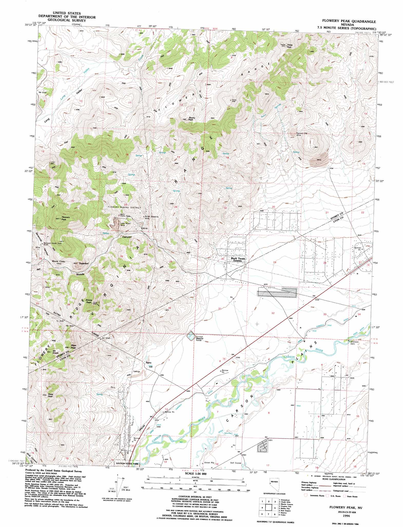
USGS Topo Quad 39119c5 - 1:24,000 scale
| Topo Map Name: | Flowery Peak |
| USGS Topo Quad ID: | 39119c5 |
| Print Size: | ca. 21 1/4" wide x 27" high |
| Southeast Coordinates: | 39.25° N latitude / 119.5° W longitude |
| Map Center Coordinates: | 39.3125° N latitude / 119.5625° W longitude |
| U.S. State: | NV |
| Filename: | o39119c5.jpg |
| Download Map JPG Image: | Flowery Peak topo map 1:24,000 scale |
| Map Type: | Topographic |
| Topo Series: | 7.5´ |
| Map Scale: | 1:24,000 |
| Source of Map Images: | United States Geological Survey (USGS) |
| Alternate Map Versions: |
Flowery Peak NV 1967, updated 1970 Download PDF Buy paper map Flowery Peak NV 1967, updated 1976 Download PDF Buy paper map Flowery Peak NV 1967, updated 1983 Download PDF Buy paper map Flowery Peak NV 1967, updated 1991 Download PDF Buy paper map Flowery Peak NV 1994, updated 1994 Download PDF Buy paper map Flowery Peak NV 2011 Download PDF Buy paper map Flowery Peak NV 2014 Download PDF Buy paper map |
1:24,000 Topo Quads surrounding Flowery Peak
Reno |
Vista |
Patrick |
Derby Dam |
Fernley West |
Mount Rose Ne |
Steamboat |
Chalk Hills |
Martin Canyon |
Stockton Well |
Washoe City |
Virginia City |
Flowery Peak |
Misfits Flat |
Churchill Butte |
Carson City |
New Empire |
Dayton |
Como |
Churchill Canyon Well |
Genoa |
Mctarnahan Hill |
Mineral Peak |
Mount Como |
Lincoln Flat |
> Back to 39119a1 at 1:100,000 scale
> Back to 39118a1 at 1:250,000 scale
> Back to U.S. Topo Maps home
Flowery Peak topo map: Gazetteer
Flowery Peak: Canals
Gee Ditch elevation 1316m 4317′Upper Cardelli Ditch elevation 1312m 4304′
Flowery Peak: Mines
Belmont-Uncle Sam Shaft elevation 1661m 5449′Berry Glory Hole elevation 1565m 5134′
Flowery Mine elevation 1528m 5013′
Lady Bryan Mine elevation 1534m 5032′
Monte Cristo Mine elevation 1674m 5492′
Natural Life Mine elevation 1632m 5354′
North Bonanza Mine elevation 1547m 5075′
Flowery Peak: Plains
Carson Plains elevation 1311m 4301′Twelve Mile Desert elevation 1322m 4337′
Flowery Peak: Populated Places
Carson Rapids City elevation 1358m 4455′Flowery City (historical) elevation 1497m 4911′
Johntown (historical) elevation 1465m 4806′
Mark Twain Estates elevation 1350m 4429′
Sutro elevation 1365m 4478′
Flowery Peak: Post Offices
Sutro Post Office (historical) elevation 1365m 4478′Flowery Peak: Ridges
Flowery Ridge elevation 1903m 6243′Flowery Peak: Springs
Sutro Springs elevation 1712m 5616′Tocchino Springs elevation 1751m 5744′
Flowery Peak: Streams
Virginia Creek elevation 1374m 4507′Flowery Peak: Summits
Emma Peak elevation 1967m 6453′Flowery Peak elevation 1997m 6551′
Kate Peak elevation 1858m 6095′
Mount Grosh elevation 1932m 6338′
Rocky Peak elevation 2123m 6965′
Rose Peak elevation 1915m 6282′
Sugarloaf elevation 1768m 5800′
Tibbie Peak elevation 2209m 7247′
Flowery Peak: Tunnels
Sutro Tunnel elevation 1737m 5698′Flowery Peak: Valleys
Long Valley elevation 1840m 6036′Sevenmile Canyon elevation 1633m 5357′
Sixmile Canyon elevation 1378m 4520′
Flowery Peak digital topo map on disk
Buy this Flowery Peak topo map showing relief, roads, GPS coordinates and other geographical features, as a high-resolution digital map file on DVD: