Lahontan Dam Topo Map Nevada
To zoom in, hover over the map of Lahontan Dam
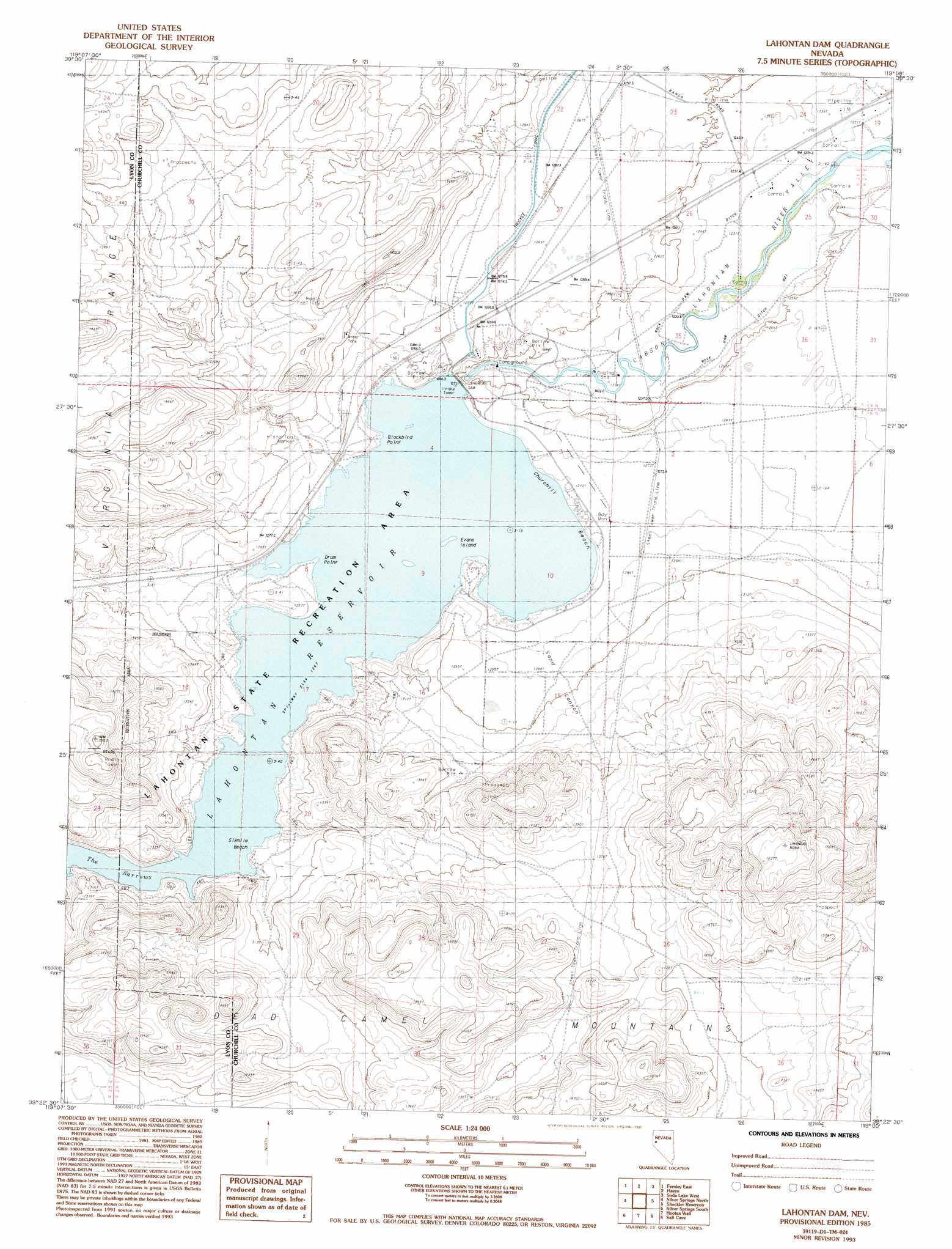
USGS Topo Quad 39119d1 - 1:24,000 scale
| Topo Map Name: | Lahontan Dam |
| USGS Topo Quad ID: | 39119d1 |
| Print Size: | ca. 21 1/4" wide x 27" high |
| Southeast Coordinates: | 39.375° N latitude / 119° W longitude |
| Map Center Coordinates: | 39.4375° N latitude / 119.0625° W longitude |
| U.S. State: | NV |
| Filename: | o39119d1.jpg |
| Download Map JPG Image: | Lahontan Dam topo map 1:24,000 scale |
| Map Type: | Topographic |
| Topo Series: | 7.5´ |
| Map Scale: | 1:24,000 |
| Source of Map Images: | United States Geological Survey (USGS) |
| Alternate Map Versions: |
Lahontan Dam NV 1985, updated 1985 Download PDF Buy paper map Lahontan Dam NV 1985, updated 1993 Download PDF Buy paper map Lahontan Dam NV 2011 Download PDF Buy paper map Lahontan Dam NV 2015 Download PDF Buy paper map |
1:24,000 Topo Quads surrounding Lahontan Dam
Wadsworth |
Two Tips |
Eagle Rock |
Soda Lake Nw |
Upsal Hogback |
Fernley West |
Fernley East |
Hazen |
Soda Lake West |
Soda Lake East |
Stockton Well |
Silver Springs North |
Lahontan Dam |
Sheckler Reservoir |
Fallon |
Churchill Butte |
Silver Springs South |
Hooten Well |
Salt Cave |
South Of Fallon |
Churchill Canyon Well |
Wabuska |
Parker Butte |
Wild Horse Basin |
Russell Spit |
> Back to 39119a1 at 1:100,000 scale
> Back to 39118a1 at 1:250,000 scale
> Back to U.S. Topo Maps home
Lahontan Dam topo map: Gazetteer
Lahontan Dam: Beaches
Churchill Beach elevation 1271m 4169′Sixmile Beach elevation 1267m 4156′
Lahontan Dam: Canals
Rock Dam Ditch elevation 1236m 4055′Rock Dam Ditch Number 1 elevation 1239m 4064′
Sky Lateral elevation 1238m 4061′
Lahontan Dam: Capes
Blackbird Point elevation 1267m 4156′Drum Point elevation 1267m 4156′
Horsemans Point elevation 1270m 4166′
Lahontan Dam: Channels
The Narrows elevation 1267m 4156′Lahontan Dam: Dams
Lahontan Dam elevation 1257m 4124′Lahontan Dam: Islands
Evans Island elevation 1267m 4156′Lahontan Dam: Parks
Lahontan State Game Refuge elevation 1271m 4169′Lahontan Dam: Populated Places
Northam (historical) elevation 1237m 4058′Lahontan Dam: Post Offices
Lahontan Post Office (historical) elevation 1278m 4192′Northam Post Office (historical) elevation 1237m 4058′
Lahontan Dam: Reservoirs
Lahontan Reservoir elevation 1257m 4124′Lahontan Dam: Valleys
Sand Canyon elevation 1272m 4173′Lahontan Dam digital topo map on disk
Buy this Lahontan Dam topo map showing relief, roads, GPS coordinates and other geographical features, as a high-resolution digital map file on DVD: