Griffith Canyon Topo Map Nevada
To zoom in, hover over the map of Griffith Canyon
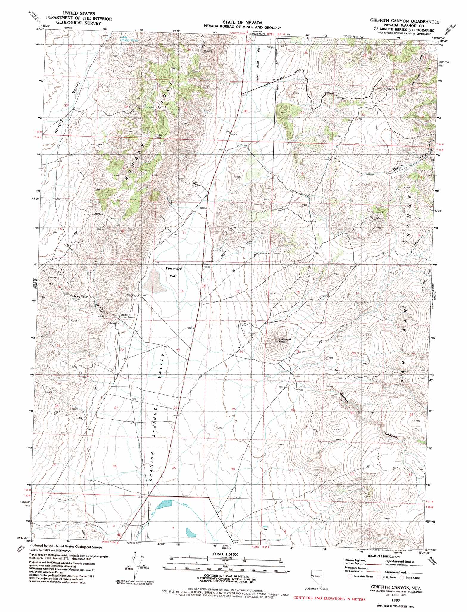
USGS Topo Quad 39119f6 - 1:24,000 scale
| Topo Map Name: | Griffith Canyon |
| USGS Topo Quad ID: | 39119f6 |
| Print Size: | ca. 21 1/4" wide x 27" high |
| Southeast Coordinates: | 39.625° N latitude / 119.625° W longitude |
| Map Center Coordinates: | 39.6875° N latitude / 119.6875° W longitude |
| U.S. State: | NV |
| Filename: | o39119f6.jpg |
| Download Map JPG Image: | Griffith Canyon topo map 1:24,000 scale |
| Map Type: | Topographic |
| Topo Series: | 7.5´ |
| Map Scale: | 1:24,000 |
| Source of Map Images: | United States Geological Survey (USGS) |
| Alternate Map Versions: |
Griffith Canyon NV 1980, updated 1980 Download PDF Buy paper map Griffith Canyon NV 1980, updated 1988 Download PDF Buy paper map Griffith Canyon NV 2011 Download PDF Buy paper map Griffith Canyon NV 2014 Download PDF Buy paper map |
1:24,000 Topo Quads surrounding Griffith Canyon
Dogskin Mountain |
Tule Peak |
Sutcliffe |
Nixon Nw |
|
Granite Peak |
Bedell Flat |
Fraser Flat |
Moses Rock |
Pah Rah Mountain |
Reno Nw |
Reno Ne |
Griffith Canyon |
Spanish Springs Peak |
Olinghouse |
Verdi |
Reno |
Vista |
Patrick |
Derby Dam |
Mount Rose Nw |
Mount Rose Ne |
Steamboat |
Chalk Hills |
Martin Canyon |
> Back to 39119e1 at 1:100,000 scale
> Back to 39118a1 at 1:250,000 scale
> Back to U.S. Topo Maps home
Griffith Canyon topo map: Gazetteer
Griffith Canyon: Airports
Nevada Flyers Airport elevation 1390m 4560′Reno Sky Ranch elevation 1386m 4547′
Griffith Canyon: Flats
Boneyard Flat elevation 1379m 4524′Griffith Canyon: Mines
Choates Mine elevation 1591m 5219′Griffith Canyon: Populated Places
Spanish Springs elevation 1377m 4517′Griffith Canyon: Ranges
Curnow Range elevation 1659m 5442′Griffith Canyon: Ridges
Hungry Ridge elevation 1834m 6017′Griffith Canyon: Springs
Little Hungry Spring elevation 1458m 4783′Griffith Canyon: Summits
Sugarloaf Peak elevation 1582m 5190′Griffith Canyon: Valleys
Axe Handle Canyon elevation 1430m 4691′Griffith Canyon elevation 1461m 4793′
Stormy Canyon elevation 1431m 4694′
Griffith Canyon digital topo map on disk
Buy this Griffith Canyon topo map showing relief, roads, GPS coordinates and other geographical features, as a high-resolution digital map file on DVD: