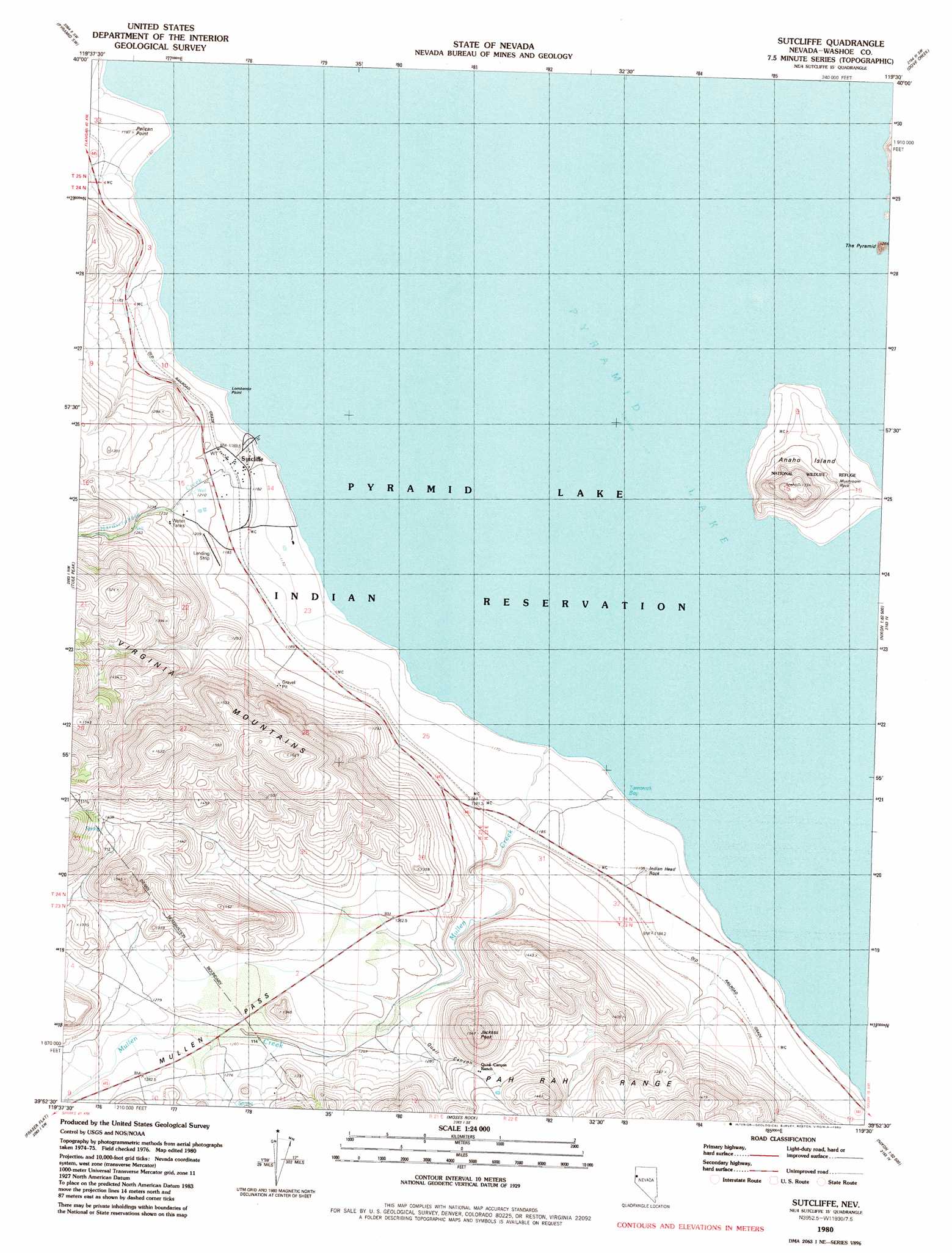
Sutcliffe Topo Map Nevada
To zoom in, hover over the map of Sutcliffe
USGS Topo Quad 39119h5 - 1:24,000 scale
| Topo Map Name: | Sutcliffe |
| USGS Topo Quad ID: | 39119h5 |
| Print Size: | ca. 21 1/4" wide x 27" high |
| Southeast Coordinates: | 39.875° N latitude / 119.5° W longitude |
| Map Center Coordinates: | 39.9375° N latitude / 119.5625° W longitude |
| U.S. State: | NV |
| Filename: | o39119h5.jpg |
| Download Map JPG Image: | Sutcliffe topo map 1:24,000 scale |
| Map Type: | Topographic |
| Topo Series: | 7.5´ |
| Map Scale: | 1:24,000 |
| Source of Map Images: | United States Geological Survey (USGS) |
| Alternate Map Versions: |
Sutcliffe NV 1980, updated 1980 Download PDF Buy paper map Sutcliffe NV 1980, updated 1980 Download PDF Buy paper map Sutcliffe NV 2011 Download PDF Buy paper map Sutcliffe NV 2014 Download PDF Buy paper map |
1:24,000 Topo Quads surrounding Sutcliffe
Astor Pass |
The Needle Rocks |
Pyramid Ne |
Tohakum Peak Nw |
Tohakum Peak Ne |
Spanish Flat |
Pyramid Sw |
Dove Creek |
Tohakum Peak Se |
|
Dogskin Mountain |
Tule Peak |
Sutcliffe |
Nixon Nw |
Russell Peak |
Bedell Flat |
Fraser Flat |
Moses Rock |
Pah Rah Mountain |
Nixon |
Reno Ne |
Griffith Canyon |
Spanish Springs Peak |
Olinghouse |
Wadsworth |
> Back to 39119e1 at 1:100,000 scale
> Back to 39118a1 at 1:250,000 scale
> Back to U.S. Topo Maps home
Sutcliffe topo map: Gazetteer
Sutcliffe: Bays
Tamarack Bay elevation 1158m 3799′Sutcliffe: Capes
Lombardo Point elevation 1164m 3818′Pelican Point elevation 1182m 3877′
Sutcliffe: Gaps
Mullen Pass elevation 1182m 3877′Sutcliffe: Islands
Anaho Island elevation 1333m 4373′The Pyramid elevation 1188m 3897′
Sutcliffe: Parks
Anaho Island National Wildlife Refuge elevation 1210m 3969′Sutcliffe: Pillars
Indian Head Rock elevation 1194m 3917′Mushroom Rock elevation 1205m 3953′
Sutcliffe: Populated Places
Sutcliffe elevation 1185m 3887′Sutcliffe: Post Offices
Dewey Post Office elevation 1280m 4199′Heply Post Office (historical) elevation 1276m 4186′
Sutcliffe Post Office (historical) elevation 1185m 3887′
Sutcliffe: Springs
Anaho Island Spring elevation 1215m 3986′Pyramid Island Hot Spring elevation 1189m 3900′
Sutcliffe: Streams
Hardscrabble Creek elevation 1159m 3802′Mullen Creek elevation 1159m 3802′
Sutcliffe: Summits
Jackass Peak elevation 1542m 5059′Sutcliffe: Valleys
Hardscrabble Cañon elevation 1203m 3946′Quail Canyon elevation 1259m 4130′
Sutcliffe digital topo map on disk
Buy this Sutcliffe topo map showing relief, roads, GPS coordinates and other geographical features, as a high-resolution digital map file on DVD: