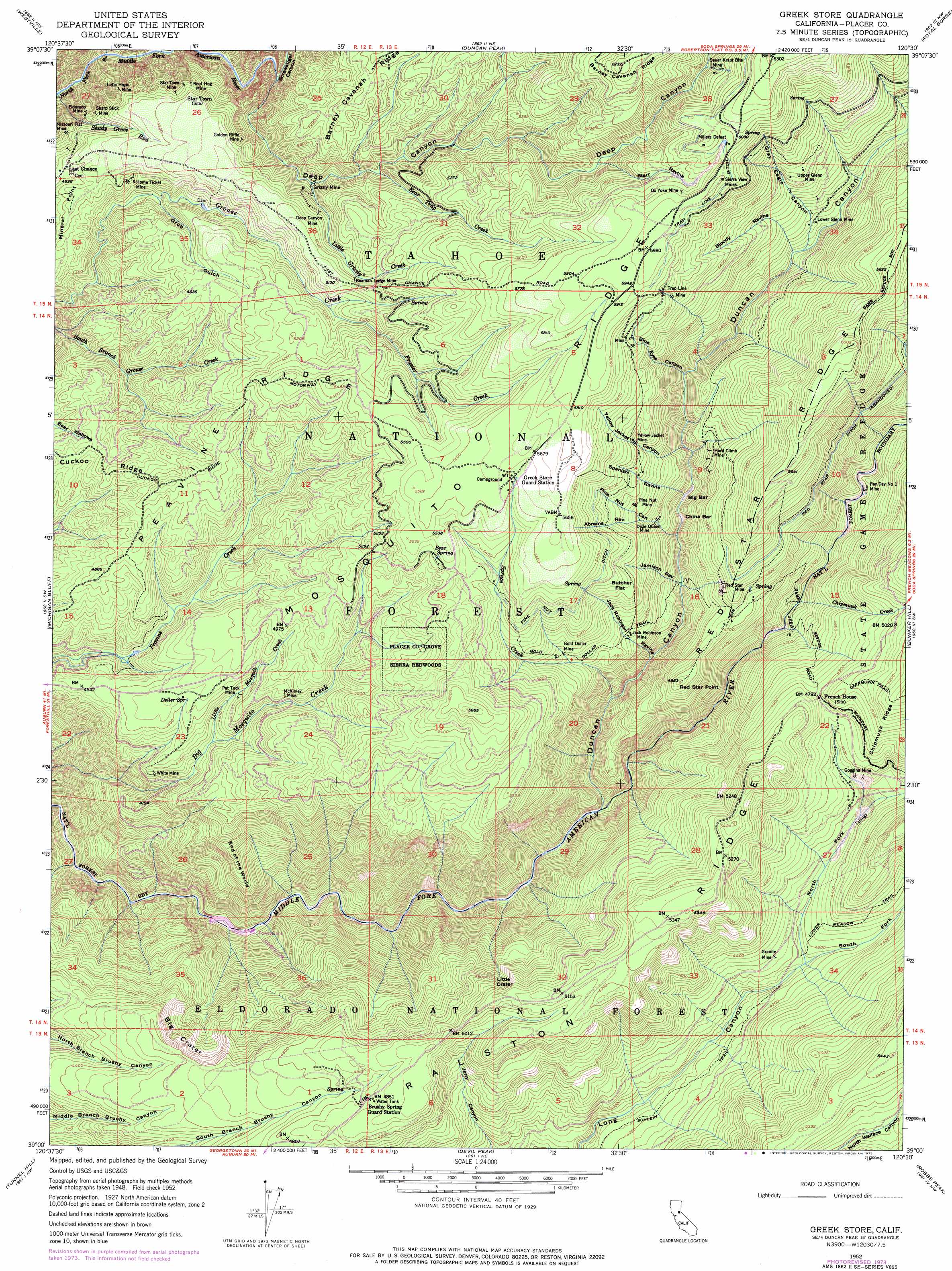
Greek Store Topo Map California
To zoom in, hover over the map of Greek Store
USGS Topo Quad 39120a5 - 1:24,000 scale
| Topo Map Name: | Greek Store |
| USGS Topo Quad ID: | 39120a5 |
| Print Size: | ca. 21 1/4" wide x 27" high |
| Southeast Coordinates: | 39° N latitude / 120.5° W longitude |
| Map Center Coordinates: | 39.0625° N latitude / 120.5625° W longitude |
| U.S. State: | CA |
| Filename: | o39120a5.jpg |
| Download Map JPG Image: | Greek Store topo map 1:24,000 scale |
| Map Type: | Topographic |
| Topo Series: | 7.5´ |
| Map Scale: | 1:24,000 |
| Source of Map Images: | United States Geological Survey (USGS) |
| Alternate Map Versions: |
Greek Store CA 1952, updated 1954 Download PDF Buy paper map Greek Store CA 1952, updated 1963 Download PDF Buy paper map Greek Store CA 1952, updated 1975 Download PDF Buy paper map Greek Store CA 1952, updated 1975 Download PDF Buy paper map Greek Store CA 2000, updated 2003 Download PDF Buy paper map Greek Store CA 2012 Download PDF Buy paper map Greek Store CA 2015 Download PDF Buy paper map |
| FStopo: | US Forest Service topo Greek Store is available: Download FStopo PDF Download FStopo TIF |
1:24,000 Topo Quads surrounding Greek Store
Washington |
Blue Canyon |
Cisco Grove |
Soda Springs |
Norden |
Dutch Flat |
Westville |
Duncan Peak |
Royal Gorge |
Granite Chief |
Foresthill |
Michigan Bluff |
Greek Store |
Bunker Hill |
Wentworth Springs |
Georgetown |
Tunnel Hill |
Devil Peak |
Robbs Peak |
Loon Lake |
Garden Valley |
Slate Mountain |
Pollock Pines |
Riverton |
Kyburz |
> Back to 39120a1 at 1:100,000 scale
> Back to 39120a1 at 1:250,000 scale
> Back to U.S. Topo Maps home
Greek Store topo map: Gazetteer
Greek Store: Bars
Big Bar elevation 1279m 4196′China Bar elevation 1274m 4179′
Greek Store: Canals
Pine Nut Ditch elevation 1600m 5249′Red Star Ditch elevation 1530m 5019′
Trap Line Ditch elevation 1828m 5997′
Greek Store: Cliffs
Big Crater elevation 1356m 4448′Little Crater elevation 1432m 4698′
Greek Store: Dams
Interbay 1030-003 Dam elevation 804m 2637′Greek Store: Flats
Butcher Flat elevation 1531m 5022′Greek Store: Mines
Beaman Ledge Mine elevation 1550m 5085′Deep Canyon Mine elevation 1471m 4826′
Dixie Queen Mine elevation 1421m 4662′
Eldorado Mine elevation 1344m 4409′
Goggins Mine elevation 1354m 4442′
Gold Dollar Mine elevation 1451m 4760′
Golden Riffle Mine elevation 1409m 4622′
Granite Mine elevation 1301m 4268′
Grizzly Mine elevation 1336m 4383′
Hard Climb Mine elevation 1385m 4543′
Home Ticket Mine elevation 1392m 4566′
Jack Robinson Mine elevation 1379m 4524′
Little Hope Mine elevation 1351m 4432′
Lower Glenn Mine elevation 1444m 4737′
McKinley Mine elevation 1422m 4665′
Millers Defeat elevation 1842m 6043′
Missouri Flat Mine elevation 1337m 4386′
Ox Yoke Mine elevation 1798m 5898′
Pat Tuck Mine elevation 1370m 4494′
Pay Day Number One Mine elevation 1272m 4173′
Pine Nut Mine elevation 1488m 4881′
Red Star Mine elevation 1427m 4681′
Root Hog Mine elevation 1425m 4675′
Sauer Kraut Bite Mine elevation 1684m 5524′
Sharp Stick Mine elevation 1370m 4494′
Sierra View Mines elevation 1833m 6013′
Star Town Mine elevation 1422m 4665′
Trap Line Mine elevation 1727m 5666′
Upper Glenn Mine elevation 1628m 5341′
White Mine elevation 1307m 4288′
Yellow Jacket Mine elevation 1582m 5190′
Greek Store: Parks
Placer County Grove Sierra Redwoods elevation 1598m 5242′Greek Store: Populated Places
Goggins elevation 1349m 4425′Goggins (historical) elevation 1359m 4458′
Greekstore elevation 1714m 5623′
Last Chance elevation 1391m 4563′
Greek Store: Ridges
End of the World elevation 1211m 3973′Mineral Point elevation 1416m 4645′
Peavine Ridge elevation 1530m 5019′
Ralston Ridge elevation 1592m 5223′
Greek Store: Springs
Bear Spring elevation 1660m 5446′Brushy Spring elevation 1457m 4780′
Deller Spring elevation 1415m 4642′
Greek Store: Streams
Bear Trap Creek elevation 1401m 4596′Chipmunk Creek elevation 1207m 3959′
Duncan Creek elevation 1021m 3349′
Frazier Creek elevation 1493m 4898′
Little Grizzly Creek elevation 1352m 4435′
Little Mosquito Creek elevation 1313m 4307′
Spruce Creek elevation 1134m 3720′
Greek Store: Summits
Red Star Point elevation 1493m 4898′Greek Store: Trails
Big Tree Nature Trail elevation 1563m 5127′Forest View Trail elevation 1603m 5259′
Gold Dollar Trail elevation 1431m 4694′
Lower Meadow Trail elevation 1350m 4429′
Schlein Trail elevation 1209m 3966′
Greek Store: Valleys
Abrams Ravine elevation 1461m 4793′Bloody Ravine elevation 1413m 4635′
Blue Eyes Canyon elevation 1341m 4399′
Deep Canyon elevation 1565m 5134′
Duncan Canyon elevation 1030m 3379′
Gray Eagle Canyon elevation 1409m 4622′
Grub Gulch elevation 1338m 4389′
Jack Robinson Ravine elevation 1181m 3874′
Jamison Ravine elevation 1232m 4041′
North Fork Long Canyon elevation 1254m 4114′
Pine Nut Canyon elevation 1267m 4156′
Screwauger Canyon elevation 1261m 4137′
South Fork Long Canyon elevation 1254m 4114′
Spanish Ravine elevation 1301m 4268′
Spring Hollow elevation 1625m 5331′
Starr Ravine elevation 1571m 5154′
Yellow Jacket Canyon elevation 1333m 4373′
Greek Store digital topo map on disk
Buy this Greek Store topo map showing relief, roads, GPS coordinates and other geographical features, as a high-resolution digital map file on DVD: