Tahoe City Topo Map California
To zoom in, hover over the map of Tahoe City
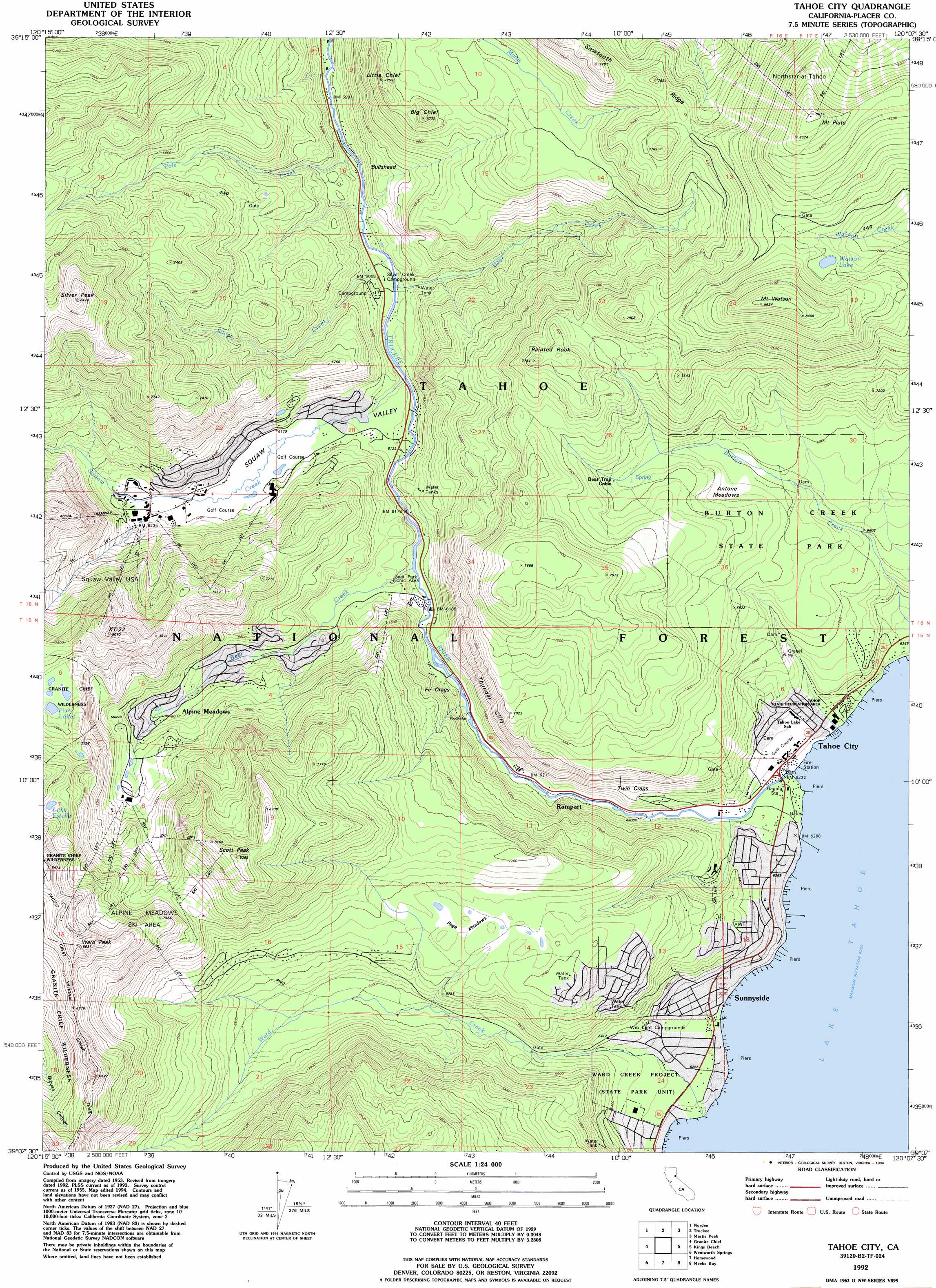
USGS Topo Quad 39120b2 - 1:24,000 scale
| Topo Map Name: | Tahoe City |
| USGS Topo Quad ID: | 39120b2 |
| Print Size: | ca. 21 1/4" wide x 27" high |
| Southeast Coordinates: | 39.125° N latitude / 120.125° W longitude |
| Map Center Coordinates: | 39.1875° N latitude / 120.1875° W longitude |
| U.S. State: | CA |
| Filename: | o39120b2.jpg |
| Download Map JPG Image: | Tahoe City topo map 1:24,000 scale |
| Map Type: | Topographic |
| Topo Series: | 7.5´ |
| Map Scale: | 1:24,000 |
| Source of Map Images: | United States Geological Survey (USGS) |
| Alternate Map Versions: |
Tahoe City CA 1955, updated 1956 Download PDF Buy paper map Tahoe City CA 1955, updated 1960 Download PDF Buy paper map Tahoe City CA 1955, updated 1971 Download PDF Buy paper map Tahoe City CA 1955, updated 1990 Download PDF Buy paper map Tahoe City CA 1992, updated 1994 Download PDF Buy paper map Tahoe City CA 2012 Download PDF Buy paper map Tahoe City CA 2015 Download PDF Buy paper map |
| FStopo: | US Forest Service topo Tahoe City is available: Download FStopo PDF Download FStopo TIF |
1:24,000 Topo Quads surrounding Tahoe City
Webber Peak |
Independence Lake |
Hobart Mills |
Boca |
Mount Rose Nw |
Soda Springs |
Norden |
Truckee |
Martis Peak |
Mount Rose |
Royal Gorge |
Granite Chief |
Tahoe City |
Kings Beach |
Marlette Lake |
Bunker Hill |
Wentworth Springs |
Homewood |
Meeks Bay |
Glenbrook |
Robbs Peak |
Loon Lake |
Rockbound Valley |
Emerald Bay |
South Lake Tahoe |
> Back to 39120a1 at 1:100,000 scale
> Back to 39120a1 at 1:250,000 scale
> Back to U.S. Topo Maps home
Tahoe City topo map: Gazetteer
Tahoe City: Bridges
Fanny Bridge elevation 1897m 6223′Tahoe City: Cliffs
Thunder Cliff elevation 2074m 6804′Twin Crags elevation 2001m 6564′
Tahoe City: Dams
Lake Tahoe Dam elevation 1897m 6223′Tahoe City: Flats
Alpine Meadows elevation 2026m 6646′Antone Meadows elevation 2095m 6873′
Page Meadows elevation 2116m 6942′
Tahoe City: Lakes
Lake Estelle elevation 2413m 7916′Watson Lake elevation 2371m 7778′
Tahoe City: Parks
Burton Creek State Park elevation 2070m 6791′Deer Park elevation 1970m 6463′
Squaw Valley State Reservation Area elevation 2051m 6729′
Tahoe City Public Beach elevation 1900m 6233′
Tahoe Park elevation 1900m 6233′
Tahoe State Recreation Area elevation 1907m 6256′
Ward Creek Project elevation 1929m 6328′
William B Layton Park elevation 1897m 6223′
Tahoe City: Pillars
Fir Crags elevation 1890m 6200′Tahoe City: Populated Places
Alpine Meadows elevation 1975m 6479′Comstock Acres elevation 1933m 6341′
Pine Land elevation 1913m 6276′
Rampart elevation 1890m 6200′
Sunnyside elevation 1908m 6259′
Tahoe City elevation 1905m 6250′
Tahoe Park elevation 1917m 6289′
Tahoe Woods elevation 1980m 6496′
Talmont elevation 2087m 6847′
Timberland elevation 1923m 6309′
Twin Peaks Estates elevation 2133m 6998′
Tahoe City: Post Offices
Tahoe City Post Office elevation 1908m 6259′Tahoe City: Reservoirs
Lake Tahoe elevation 1897m 6223′Tahoe City: Streams
Bear Creek elevation 1886m 6187′Deer Creek elevation 1846m 6056′
Pole Creek elevation 1829m 6000′
Silver Creek elevation 1841m 6040′
Squaw Creek elevation 1853m 6079′
Ward Creek elevation 1900m 6233′
Tahoe City: Summits
Big Chief elevation 2234m 7329′Bullshead elevation 1927m 6322′
KT-22 elevation 2430m 7972′
Little Chief elevation 2210m 7250′
Mount Pluto elevation 2625m 8612′
Mount Watson elevation 2566m 8418′
Painted Rock elevation 2353m 7719′
Poulsen Peak elevation 2332m 7650′
Scott Peak elevation 2517m 8257′
Silver Peak elevation 2556m 8385′
Ward Peak elevation 2622m 8602′
Tahoe City: Valleys
Squaw Valley elevation 1853m 6079′Tahoe City digital topo map on disk
Buy this Tahoe City topo map showing relief, roads, GPS coordinates and other geographical features, as a high-resolution digital map file on DVD: