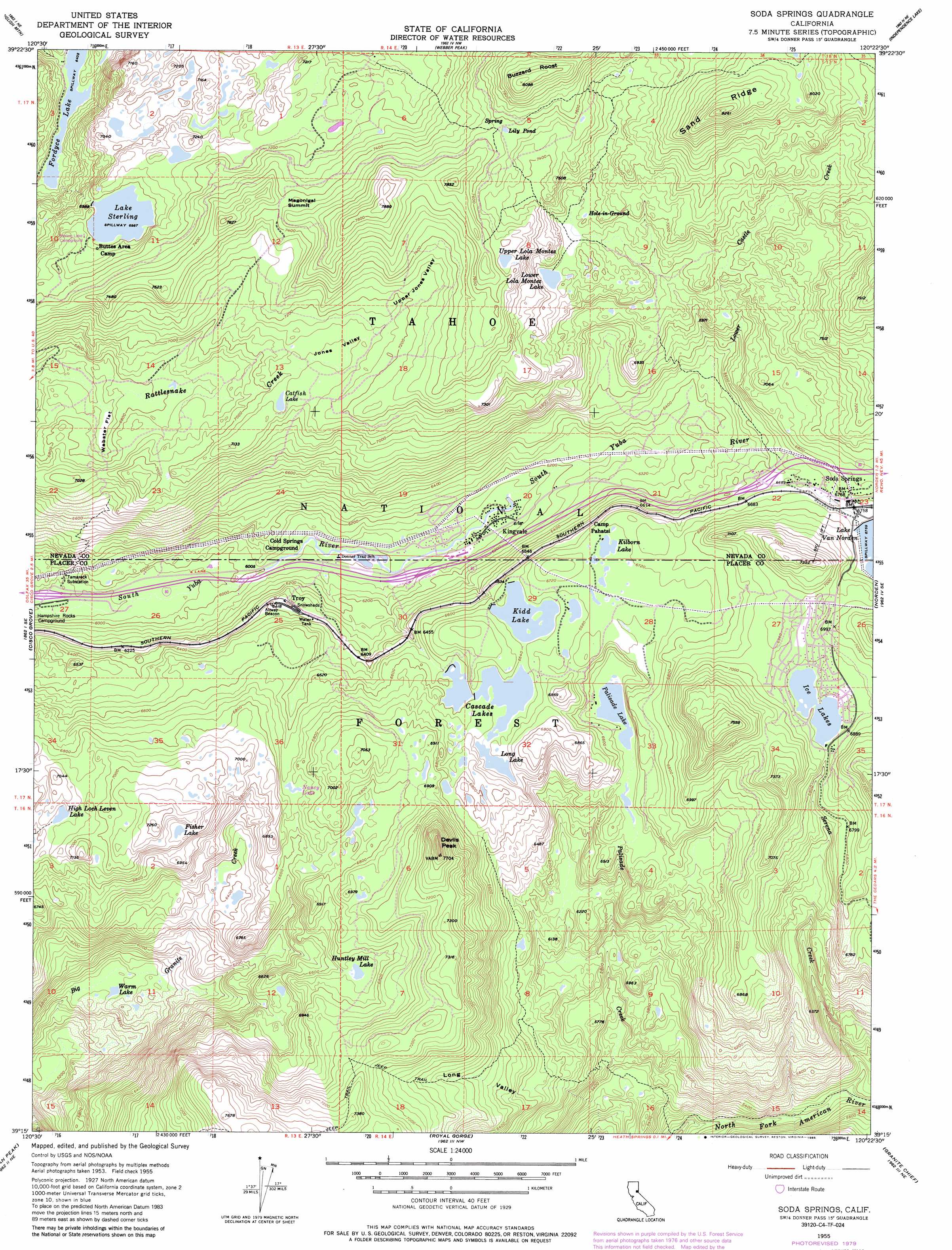
Soda Springs Topo Map California
To zoom in, hover over the map of Soda Springs
USGS Topo Quad 39120c4 - 1:24,000 scale
| Topo Map Name: | Soda Springs |
| USGS Topo Quad ID: | 39120c4 |
| Print Size: | ca. 21 1/4" wide x 27" high |
| Southeast Coordinates: | 39.25° N latitude / 120.375° W longitude |
| Map Center Coordinates: | 39.3125° N latitude / 120.4375° W longitude |
| U.S. State: | CA |
| Filename: | o39120c4.jpg |
| Download Map JPG Image: | Soda Springs topo map 1:24,000 scale |
| Map Type: | Topographic |
| Topo Series: | 7.5´ |
| Map Scale: | 1:24,000 |
| Source of Map Images: | United States Geological Survey (USGS) |
| Alternate Map Versions: |
Soda Springs CA 1955, updated 1957 Download PDF Buy paper map Soda Springs CA 1955, updated 1962 Download PDF Buy paper map Soda Springs CA 1955, updated 1973 Download PDF Buy paper map Soda Springs CA 1955, updated 1976 Download PDF Buy paper map Soda Springs CA 1955, updated 1980 Download PDF Buy paper map Soda Springs CA 1955, updated 1983 Download PDF Buy paper map Soda Springs CA 1955, updated 1985 Download PDF Buy paper map Soda Springs CA 1955, updated 1985 Download PDF Buy paper map Soda Springs CA 2000, updated 2003 Download PDF Buy paper map Soda Springs CA 2012 Download PDF Buy paper map Soda Springs CA 2015 Download PDF Buy paper map |
| FStopo: | US Forest Service topo Soda Springs is available: Download FStopo PDF Download FStopo TIF |
1:24,000 Topo Quads surrounding Soda Springs
Sierra City |
Haypress Valley |
Sattley |
Sierraville |
Sardine Peak |
Graniteville |
English Mountain |
Webber Peak |
Independence Lake |
Hobart Mills |
Blue Canyon |
Cisco Grove |
Soda Springs |
Norden |
Truckee |
Westville |
Duncan Peak |
Royal Gorge |
Granite Chief |
Tahoe City |
Michigan Bluff |
Greek Store |
Bunker Hill |
Wentworth Springs |
Homewood |
> Back to 39120a1 at 1:100,000 scale
> Back to 39120a1 at 1:250,000 scale
> Back to U.S. Topo Maps home
Soda Springs topo map: Gazetteer
Soda Springs: Dams
Ice Lakes 1324 Dam elevation 2097m 6879′Kidd Lake 97-025 Dam elevation 2023m 6637′
Lake Sterling 97-030 Dam elevation 2131m 6991′
Lower Peak Lake 97-037 Dam elevation 2004m 6574′
Upper Peak Lake 97-047 Dam elevation 2022m 6633′
Soda Springs: Flats
Webster Flat elevation 2046m 6712′Soda Springs: Gaps
Magonigal Summit elevation 2272m 7454′Soda Springs: Lakes
Catfish Lake elevation 2152m 7060′Derry Lake elevation 2178m 7145′
Dulzura Lake elevation 2096m 6876′
Fisher Lake elevation 2141m 7024′
High Loch Leven Lake elevation 2091m 6860′
Hole-In-Ground elevation 2184m 7165′
Huntley Mill Lake elevation 2043m 6702′
Ice Lakes elevation 2096m 6876′
Jerry Lake elevation 2180m 7152′
Kilborn Lake elevation 2040m 6692′
Lily Pond elevation 2306m 7565′
Long Lake elevation 2021m 6630′
Lower Lola Montez Lake elevation 2176m 7139′
Nancy Lake elevation 2045m 6709′
Natalie Lake elevation 1945m 6381′
Palisade Lake elevation 1983m 6505′
Serena Lake elevation 2096m 6876′
Upper Lola Montez Lake elevation 2301m 7549′
Warm Lake elevation 1728m 5669′
Soda Springs: Populated Places
Kingvale elevation 1869m 6131′Soda Springs elevation 2063m 6768′
Spruce (historical) elevation 1999m 6558′
Tamarack (historical) elevation 1897m 6223′
Troy elevation 1934m 6345′
Soda Springs: Post Offices
Soda Springs Post Office elevation 2042m 6699′Soda Springs: Reservoirs
Cascade Lakes elevation 2022m 6633′Kidd Lake elevation 2023m 6637′
Lake Sterling elevation 2131m 6991′
Lake Van Norden elevation 2064m 6771′
Soda Springs: Ridges
Sand Ridge elevation 2519m 8264′Soda Springs: Streams
Lower Castle Creek elevation 1944m 6377′Serena Creek elevation 1609m 5278′
Soda Springs: Summits
Buzzard Roost elevation 2467m 8093′Devils Peak elevation 2290m 7513′
Mount Marliave elevation 2176m 7139′
Soda Springs: Trails
Glacier Lakes Trail elevation 2166m 7106′Heath Falls Overlook Trail elevation 1624m 5328′
Lola Montez Trail elevation 2065m 6774′
Long Valley Trail elevation 2030m 6660′
Mossy Pond East Trail elevation 2143m 7030′
Mossy Pond West Trail elevation 2134m 7001′
Palisades Creek Trail elevation 1869m 6131′
Soda Springs: Valleys
Jones Valley elevation 2145m 7037′Long Valley elevation 1622m 5321′
Upper Jones Valley elevation 2173m 7129′
Soda Springs digital topo map on disk
Buy this Soda Springs topo map showing relief, roads, GPS coordinates and other geographical features, as a high-resolution digital map file on DVD: