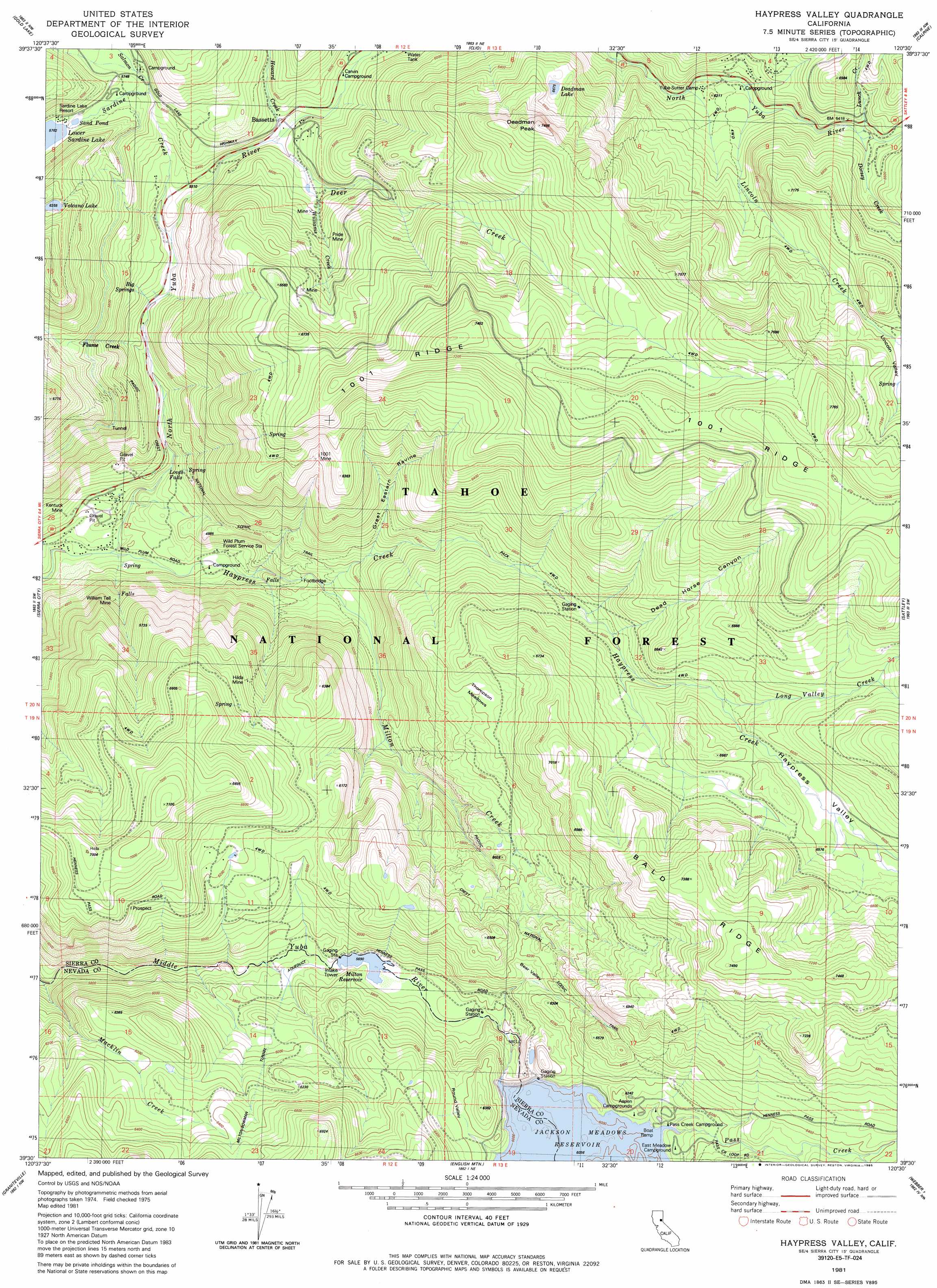
Haypress Valley Topo Map California
To zoom in, hover over the map of Haypress Valley
USGS Topo Quad 39120e5 - 1:24,000 scale
| Topo Map Name: | Haypress Valley |
| USGS Topo Quad ID: | 39120e5 |
| Print Size: | ca. 21 1/4" wide x 27" high |
| Southeast Coordinates: | 39.5° N latitude / 120.5° W longitude |
| Map Center Coordinates: | 39.5625° N latitude / 120.5625° W longitude |
| U.S. State: | CA |
| Filename: | o39120e5.jpg |
| Download Map JPG Image: | Haypress Valley topo map 1:24,000 scale |
| Map Type: | Topographic |
| Topo Series: | 7.5´ |
| Map Scale: | 1:24,000 |
| Source of Map Images: | United States Geological Survey (USGS) |
| Alternate Map Versions: |
Haypress Valley CA 1981, updated 1982 Download PDF Buy paper map Haypress Valley CA 1981, updated 1985 Download PDF Buy paper map Haypress Valley CA 1981, updated 1985 Download PDF Buy paper map Haypress Valley CA 2000, updated 2003 Download PDF Buy paper map Haypress Valley CA 2012 Download PDF Buy paper map Haypress Valley CA 2015 Download PDF Buy paper map |
| FStopo: | US Forest Service topo Haypress Valley is available: Download FStopo PDF Download FStopo TIF |
1:24,000 Topo Quads surrounding Haypress Valley
Blue Nose Mountain |
Johnsville |
Blairsden |
Portola |
Reconnaissance Peak |
Mount Fillmore |
Gold Lake |
Clio |
Calpine |
Antelope Valley |
Downieville |
Sierra City |
Haypress Valley |
Sattley |
Sierraville |
Alleghany |
Graniteville |
English Mountain |
Webber Peak |
Independence Lake |
Washington |
Blue Canyon |
Cisco Grove |
Soda Springs |
Norden |
> Back to 39120e1 at 1:100,000 scale
> Back to 39120a1 at 1:250,000 scale
> Back to U.S. Topo Maps home
Haypress Valley topo map: Gazetteer
Haypress Valley: Dams
Jackson Meadows 61-020 Dam elevation 1841m 6040′Lower Sardine Lake 1-051 Dam elevation 2125m 6971′
Milton Diversion 61-007 Dam elevation 1740m 5708′
Haypress Valley: Falls
Loves Falls elevation 1444m 4737′Haypress Valley: Flats
Jackson Meadows (historical) elevation 1841m 6040′Round Valley elevation 1889m 6197′
Thompson Meadows elevation 1904m 6246′
Haypress Valley: Forests
Tahoe National Forest elevation 1923m 6309′Haypress Valley: Lakes
Deadman Lake elevation 2037m 6683′Lower Sardine Lake elevation 1757m 5764′
Sand Pond elevation 1755m 5757′
Volcano Lake elevation 1939m 6361′
Haypress Valley: Mines
Chipps Mine elevation 1563m 5127′Hilda Mine elevation 1785m 5856′
Kentuck Mine elevation 1346m 4416′
One Hundred One Mine elevation 1876m 6154′
Phoenix Mine elevation 1708m 5603′
Pride Mine elevation 1696m 5564′
William Tell Mine elevation 1489m 4885′
Haypress Valley: Populated Places
Bassetts elevation 1688m 5538′Milton (historical) elevation 1753m 5751′
Haypress Valley: Reservoirs
Jackson Meadows Reservoir elevation 1841m 6040′Milton Reservoir elevation 1735m 5692′
Haypress Valley: Ridges
Bald Ridge elevation 2214m 7263′Haypress Valley: Springs
Big Springs elevation 1586m 5203′Haypress Valley: Streams
Deer Creek elevation 1633m 5357′Dorsey Creek elevation 1958m 6423′
Flume Creek elevation 1481m 4858′
Haypress Creek elevation 1305m 4281′
Howard Creek elevation 1639m 5377′
Lincoln Creek elevation 1881m 6171′
Long Valley Creek elevation 1925m 6315′
Lunch Creek elevation 1941m 6368′
Milton Creek elevation 1471m 4826′
Pass Creek elevation 1841m 6040′
Salmon Creek elevation 1581m 5187′
Sardine Creek elevation 1744m 5721′
William Creek elevation 1634m 5360′
Williams Creek elevation 1657m 5436′
Haypress Valley: Summits
Deadman Peak elevation 2261m 7417′Haypress Valley: Trails
Haypress Creek Trail elevation 1715m 5626′Haypress Valley: Valleys
Bear Valley elevation 1770m 5807′Dead Horse Canyon elevation 1833m 6013′
Great Eastern Ravine elevation 1575m 5167′
Haypress Valley elevation 1305m 4281′
Lincoln Valley elevation 1882m 6174′
Haypress Valley digital topo map on disk
Buy this Haypress Valley topo map showing relief, roads, GPS coordinates and other geographical features, as a high-resolution digital map file on DVD: