Loyalton Topo Map California
To zoom in, hover over the map of Loyalton
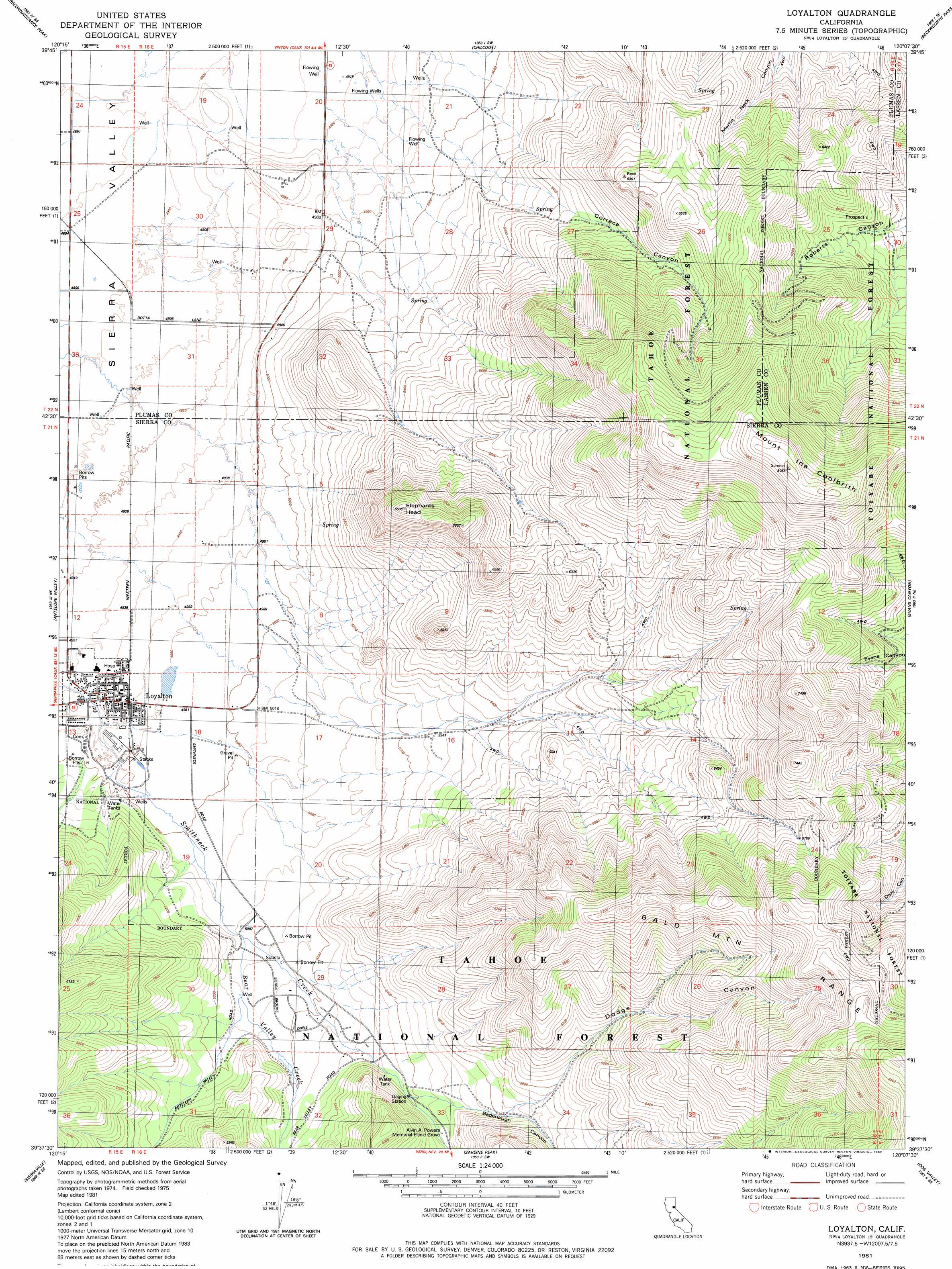
USGS Topo Quad 39120f2 - 1:24,000 scale
| Topo Map Name: | Loyalton |
| USGS Topo Quad ID: | 39120f2 |
| Print Size: | ca. 21 1/4" wide x 27" high |
| Southeast Coordinates: | 39.625° N latitude / 120.125° W longitude |
| Map Center Coordinates: | 39.6875° N latitude / 120.1875° W longitude |
| U.S. State: | CA |
| Filename: | o39120f2.jpg |
| Download Map JPG Image: | Loyalton topo map 1:24,000 scale |
| Map Type: | Topographic |
| Topo Series: | 7.5´ |
| Map Scale: | 1:24,000 |
| Source of Map Images: | United States Geological Survey (USGS) |
| Alternate Map Versions: |
Loyalton CA 1981, updated 1982 Download PDF Buy paper map Loyalton CA 2000, updated 2003 Download PDF Buy paper map Loyalton CA 2012 Download PDF Buy paper map Loyalton CA 2015 Download PDF Buy paper map |
| FStopo: | US Forest Service topo Loyalton is available: Download FStopo PDF Download FStopo TIF |
1:24,000 Topo Quads surrounding Loyalton
Crocker Mountain |
Dixie Mountain |
Frenchman Lake |
Constantia |
|
Portola |
Reconnaissance Peak |
Chilcoot |
Beckwourth Pass |
Granite Peak |
Calpine |
Antelope Valley |
Loyalton |
Evans Canyon |
Reno Nw |
Sattley |
Sierraville |
Sardine Peak |
Dog Valley |
Verdi |
Webber Peak |
Independence Lake |
Hobart Mills |
Boca |
Mount Rose Nw |
> Back to 39120e1 at 1:100,000 scale
> Back to 39120a1 at 1:250,000 scale
> Back to U.S. Topo Maps home
Loyalton topo map: Gazetteer
Loyalton: Mines
Flying Dutchman Mine elevation 1749m 5738′Loyalton: Parks
Loyalton Park elevation 1503m 4931′Loyalton: Populated Places
Loyalton elevation 1509m 4950′Sierra Subdivision elevation 1578m 5177′
Loyalton: Streams
Bear Valley Creek elevation 1551m 5088′Loyalton: Summits
Elephants Head elevation 1991m 6532′Mount Ina Coolbrith elevation 2454m 8051′
Loyalton: Valleys
Badenaugh Canyon elevation 1670m 5479′Correco Canyon elevation 1579m 5180′
Dodge Canyon elevation 1732m 5682′
Loyalton digital topo map on disk
Buy this Loyalton topo map showing relief, roads, GPS coordinates and other geographical features, as a high-resolution digital map file on DVD: