Gold Lake Topo Map California
To zoom in, hover over the map of Gold Lake
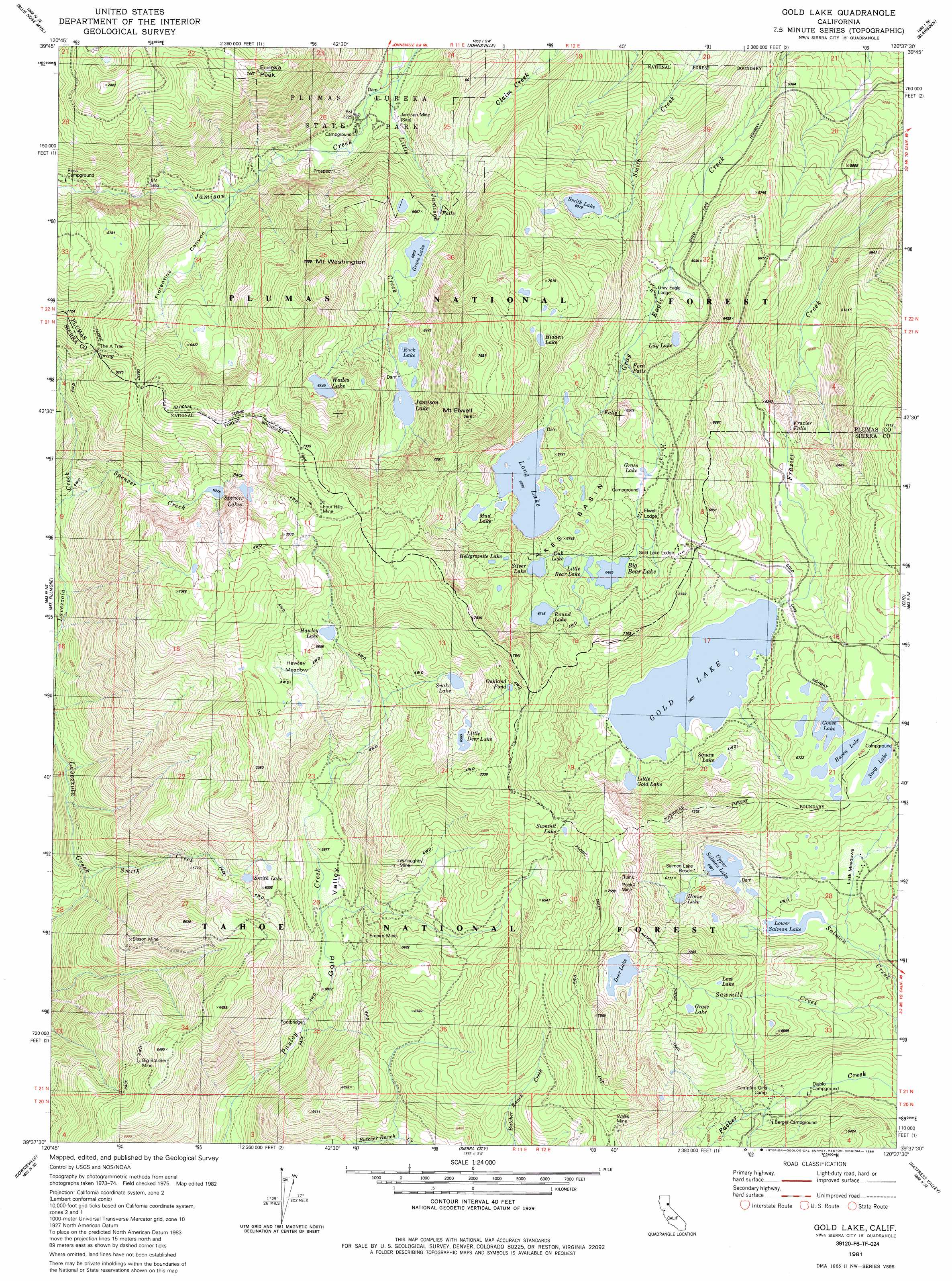
USGS Topo Quad 39120f6 - 1:24,000 scale
| Topo Map Name: | Gold Lake |
| USGS Topo Quad ID: | 39120f6 |
| Print Size: | ca. 21 1/4" wide x 27" high |
| Southeast Coordinates: | 39.625° N latitude / 120.625° W longitude |
| Map Center Coordinates: | 39.6875° N latitude / 120.6875° W longitude |
| U.S. State: | CA |
| Filename: | o39120f6.jpg |
| Download Map JPG Image: | Gold Lake topo map 1:24,000 scale |
| Map Type: | Topographic |
| Topo Series: | 7.5´ |
| Map Scale: | 1:24,000 |
| Source of Map Images: | United States Geological Survey (USGS) |
| Alternate Map Versions: |
Gold Lake CA 1981, updated 1982 Download PDF Buy paper map Gold Lake CA 1981, updated 1985 Download PDF Buy paper map Gold Lake CA 1981, updated 1986 Download PDF Buy paper map Gold Lake CA 2000, updated 2003 Download PDF Buy paper map Gold Lake CA 2012 Download PDF Buy paper map Gold Lake CA 2015 Download PDF Buy paper map |
| FStopo: | US Forest Service topo Gold Lake is available: Download FStopo PDF Download FStopo TIF |
1:24,000 Topo Quads surrounding Gold Lake
Quincy |
Spring Garden |
Mount Ingalls |
Grizzly Valley |
Crocker Mountain |
Onion Valley |
Blue Nose Mountain |
Johnsville |
Blairsden |
Portola |
La Porte |
Mount Fillmore |
Gold Lake |
Clio |
Calpine |
Goodyears Bar |
Downieville |
Sierra City |
Haypress Valley |
Sattley |
Pike |
Alleghany |
Graniteville |
English Mountain |
Webber Peak |
> Back to 39120e1 at 1:100,000 scale
> Back to 39120a1 at 1:250,000 scale
> Back to U.S. Topo Maps home
Gold Lake topo map: Gazetteer
Gold Lake: Basins
Lakes Basin elevation 2042m 6699′Gold Lake: Dams
Deer Lake Dam elevation 2165m 7103′Long Lake 289 Dam elevation 1999m 6558′
Lower Salmon Lake Dam elevation 1944m 6377′
Snag Lake Dam elevation 2034m 6673′
Upper Salmon Lake Dam elevation 1982m 6502′
Gold Lake: Falls
Fern Falls elevation 1813m 5948′Frazier Falls elevation 1828m 5997′
Gold Lake: Flats
Hawley Meadow elevation 2034m 6673′Lusk Meadows elevation 1967m 6453′
Gold Lake: Lakes
Big Bear Lake elevation 1978m 6489′Cub Lake elevation 1998m 6555′
Gold Lake elevation 1954m 6410′
Goose Lake elevation 2023m 6637′
Grass Lake elevation 1787m 5862′
Grass Lake elevation 2070m 6791′
Grass Lake elevation 1921m 6302′
Haven Lake elevation 2031m 6663′
Hawley Lake elevation 2017m 6617′
Hellgrammite Lake elevation 2019m 6624′
Hidden Lake elevation 2091m 6860′
Horse Lake elevation 2015m 6610′
Jamison Lake elevation 1910m 6266′
Lily Lake elevation 1820m 5971′
Little Bear Lake elevation 1981m 6499′
Little Deer Lake elevation 2124m 6968′
Little Gold Lake elevation 1961m 6433′
Lost Lake elevation 2065m 6774′
Mud Lake elevation 2006m 6581′
Oakland Pond elevation 2227m 7306′
Rock Lake elevation 1922m 6305′
Round Lake elevation 2049m 6722′
Silver Lake elevation 2034m 6673′
Smith Lake elevation 1854m 6082′
Smith Lake elevation 1834m 6017′
Snake Lake elevation 2057m 6748′
Spencer Lakes elevation 1967m 6453′
Squaw Lake elevation 2043m 6702′
Summit Lake elevation 2163m 7096′
Wades Lake elevation 1997m 6551′
Gold Lake: Mines
Big Boulder Mine elevation 1910m 6266′Empire Mine elevation 1856m 6089′
Four Hills Mine elevation 2186m 7171′
Jamison Mine elevation 1635m 5364′
Peck Mine elevation 2100m 6889′
Sisson Mine elevation 1814m 5951′
Wallis Mine elevation 2127m 6978′
Willoughby Mine elevation 1972m 6469′
Gold Lake: Parks
Lake Basin Recreation Area elevation 2022m 6633′Gold Lake: Populated Places
Little Jamison (historical) elevation 1606m 5269′Gold Lake: Reservoirs
Deer Lake elevation 2161m 7089′Deer Lake elevation 2165m 7103′
Long Lake elevation 1999m 6558′
Lower Salmon Lake elevation 1943m 6374′
Lower Salmon Lake elevation 1944m 6377′
Snag Lake elevation 2034m 6673′
Snag Lake elevation 2037m 6683′
Upper Salmon Lake elevation 1982m 6502′
Upper Salmon Lake elevation 1980m 6496′
Gold Lake: Streams
Church Creek elevation 1924m 6312′Little Jamison Creek elevation 1598m 5242′
Sawmill Creek elevation 1859m 6099′
Smith Creek elevation 1415m 4642′
Spencer Creek elevation 1655m 5429′
Gold Lake: Summits
Eureka Peak elevation 2183m 7162′Mount Elwell elevation 2361m 7746′
Mount Washington elevation 2236m 7335′
Gold Lake: Trails
Deer Lake Trail elevation 2038m 6686′Upper Salmon Lake Trail elevation 2008m 6587′
Gold Lake: Valleys
Florentine Canyon elevation 1698m 5570′Gold Lake digital topo map on disk
Buy this Gold Lake topo map showing relief, roads, GPS coordinates and other geographical features, as a high-resolution digital map file on DVD: