Reconnaissance Peak Topo Map California
To zoom in, hover over the map of Reconnaissance Peak
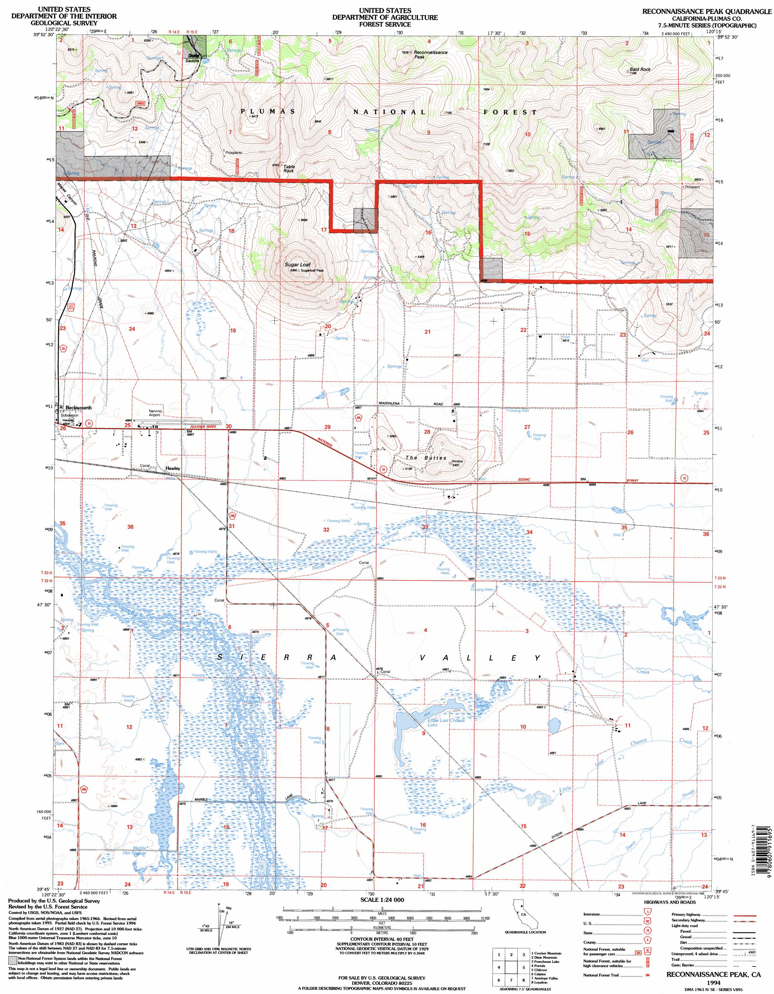
USGS Topo Quad 39120g3 - 1:24,000 scale
| Topo Map Name: | Reconnaissance Peak |
| USGS Topo Quad ID: | 39120g3 |
| Print Size: | ca. 21 1/4" wide x 27" high |
| Southeast Coordinates: | 39.75° N latitude / 120.25° W longitude |
| Map Center Coordinates: | 39.8125° N latitude / 120.3125° W longitude |
| U.S. State: | CA |
| Filename: | o39120g3.jpg |
| Download Map JPG Image: | Reconnaissance Peak topo map 1:24,000 scale |
| Map Type: | Topographic |
| Topo Series: | 7.5´ |
| Map Scale: | 1:24,000 |
| Source of Map Images: | United States Geological Survey (USGS) |
| Alternate Map Versions: |
Reconnaissance Peak CA 1972, updated 1974 Download PDF Buy paper map Reconnaissance Peak CA 1972, updated 1974 Download PDF Buy paper map Reconnaissance Peak CA 1994, updated 1998 Download PDF Buy paper map Reconnaissance Peak CA 2012 Download PDF Buy paper map Reconnaissance Peak CA 2015 Download PDF Buy paper map |
| FStopo: | US Forest Service topo Reconnaissance Peak is available: Download FStopo PDF Download FStopo TIF |
1:24,000 Topo Quads surrounding Reconnaissance Peak
Babcock Peak |
Squaw Valley Peak |
Ferris Creek |
Mckesick Peak |
Doyle |
Grizzly Valley |
Crocker Mountain |
Dixie Mountain |
Frenchman Lake |
Constantia |
Blairsden |
Portola |
Reconnaissance Peak |
Chilcoot |
Beckwourth Pass |
Clio |
Calpine |
Antelope Valley |
Loyalton |
Evans Canyon |
Haypress Valley |
Sattley |
Sierraville |
Sardine Peak |
Dog Valley |
> Back to 39120e1 at 1:100,000 scale
> Back to 39120a1 at 1:250,000 scale
> Back to U.S. Topo Maps home
Reconnaissance Peak topo map: Gazetteer
Reconnaissance Peak: Airports
Nervino Airport elevation 1492m 4895′Reconnaissance Peak: Gaps
Dotta Saddle elevation 1834m 6017′Reconnaissance Peak: Lakes
Little Last Chance Lake elevation 1488m 4881′Reconnaissance Peak: Populated Places
Hawley elevation 1488m 4881′Reconnaissance Peak: Springs
Marble Hot Springs elevation 1490m 4888′Reconnaissance Peak: Streams
East Channel Little Last Chance Creek elevation 1489m 4885′North Channel Little Last Chance Creek elevation 1485m 4872′
Reconnaissance Peak: Summits
Bald Rock elevation 2181m 7155′Reconnaissance Peak elevation 2285m 7496′
Sugar Loaf elevation 1946m 6384′
Table Rock elevation 1851m 6072′
The Buttes elevation 1643m 5390′
Reconnaissance Peak: Valleys
Mapes Canyon elevation 1524m 5000′Reconnaissance Peak digital topo map on disk
Buy this Reconnaissance Peak topo map showing relief, roads, GPS coordinates and other geographical features, as a high-resolution digital map file on DVD: