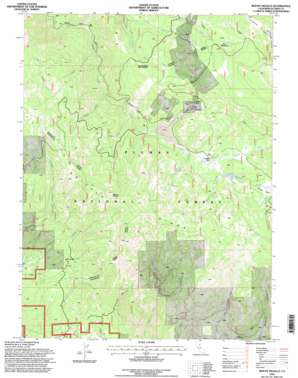
Mount Ingalls Topo Map California
To zoom in, hover over the map of Mount Ingalls
USGS Topo Quad 39120h6 - 1:24,000 scale
| Topo Map Name: | Mount Ingalls |
| USGS Topo Quad ID: | 39120h6 |
| Print Size: | ca. 21 1/4" wide x 27" high |
| Southeast Coordinates: | 39.875° N latitude / 120.625° W longitude |
| Map Center Coordinates: | 39.9375° N latitude / 120.6875° W longitude |
| U.S. State: | CA |
| Filename: | o39120h6.jpg |
| Download Map JPG Image: | Mount Ingalls topo map 1:24,000 scale |
| Map Type: | Topographic |
| Topo Series: | 7.5´ |
| Map Scale: | 1:24,000 |
| Source of Map Images: | United States Geological Survey (USGS) |
| Alternate Map Versions: |
Mt. Ingalls CA 1972, updated 1974 Download PDF Buy paper map Mount Ingalls CA 1994, updated 1998 Download PDF Buy paper map Mount Ingalls CA 1994, updated 1998 Download PDF Buy paper map Mount Ingalls CA 2012 Download PDF Buy paper map Mount Ingalls CA 2015 Download PDF Buy paper map |
| FStopo: | US Forest Service topo Mount Ingalls is available: Download FStopo PDF Download FStopo TIF |
1:24,000 Topo Quads surrounding Mount Ingalls
> Back to 39120e1 at 1:100,000 scale
> Back to 39120a1 at 1:250,000 scale
> Back to U.S. Topo Maps home
Mount Ingalls topo map: Gazetteer
Mount Ingalls: Dams
Walker Mine Tailings Dam elevation 1747m 5731′Mount Ingalls: Flats
Nye Meadows elevation 2189m 7181′Mount Ingalls: Lakes
Little Summit Lake elevation 1775m 5823′Mount Ingalls: Mines
Walker Consolidated Mine elevation 1937m 6354′Walker Mine elevation 1887m 6190′
Mount Ingalls: Populated Places
Lovejoy (historical) elevation 1770m 5807′Walkermine (historical) elevation 1852m 6076′
Mount Ingalls: Reservoirs
Walker Mine Tailings Reservoir elevation 1747m 5731′Mount Ingalls: Ridges
Grizzly Ridge elevation 2190m 7185′Turner Ridge elevation 2549m 8362′
Mount Ingalls: Streams
Blakeless Creek elevation 1768m 5800′Bull Run Creek elevation 1613m 5291′
Cascade Creek elevation 1641m 5383′
Dolly Creek elevation 1741m 5711′
Emigrant Creek elevation 1757m 5764′
Joseph Creek elevation 1556m 5104′
Lovejoy Creek elevation 1764m 5787′
Middle Branch Ward Creek elevation 1686m 5531′
Oliver Creek elevation 1468m 4816′
Paradise Creek elevation 1767m 5797′
Rock Creek elevation 1387m 4550′
South Fork Long Valley Creek elevation 1686m 5531′
Mount Ingalls: Summits
Mount Ingalls elevation 2542m 8339′Mount Ingalls: Swamps
Summit Marsh elevation 1776m 5826′Mount Ingalls: Valleys
McDermott Ravine elevation 1359m 4458′Missouri Gulch elevation 1696m 5564′
Mount Ingalls digital topo map on disk
Buy this Mount Ingalls topo map showing relief, roads, GPS coordinates and other geographical features, as a high-resolution digital map file on DVD:


