Strawberry Valley Topo Map California
To zoom in, hover over the map of Strawberry Valley
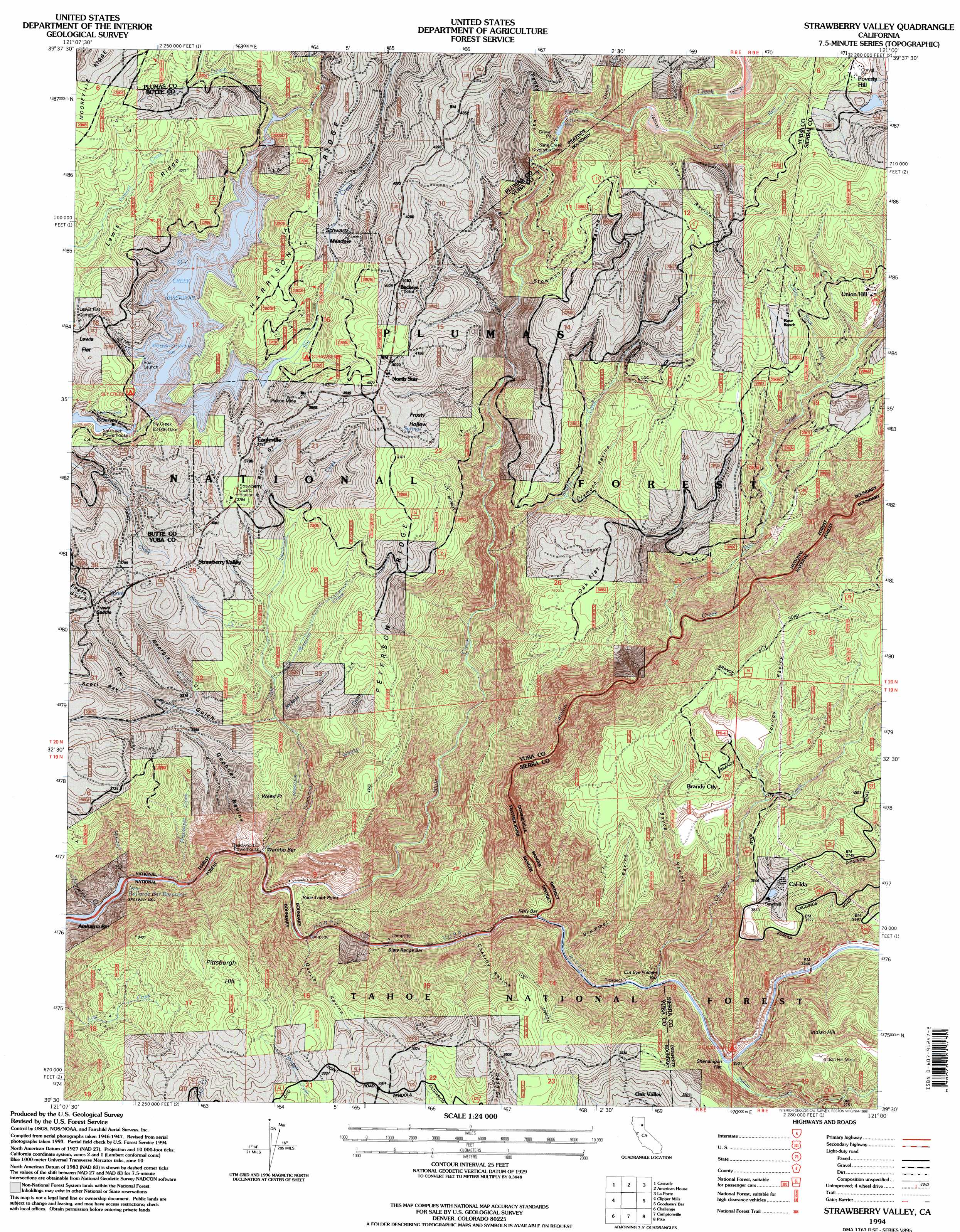
USGS Topo Quad 39121e1 - 1:24,000 scale
| Topo Map Name: | Strawberry Valley |
| USGS Topo Quad ID: | 39121e1 |
| Print Size: | ca. 21 1/4" wide x 27" high |
| Southeast Coordinates: | 39.5° N latitude / 121° W longitude |
| Map Center Coordinates: | 39.5625° N latitude / 121.0625° W longitude |
| U.S. State: | CA |
| Filename: | o39121e1.jpg |
| Download Map JPG Image: | Strawberry Valley topo map 1:24,000 scale |
| Map Type: | Topographic |
| Topo Series: | 7.5´ |
| Map Scale: | 1:24,000 |
| Source of Map Images: | United States Geological Survey (USGS) |
| Alternate Map Versions: |
Strawberry Valley CA 1948, updated 1957 Download PDF Buy paper map Strawberry Valley CA 1948, updated 1965 Download PDF Buy paper map Strawberry Valley CA 1948, updated 1977 Download PDF Buy paper map Strawberry Valley CA 1948, updated 1991 Download PDF Buy paper map Strawberry Valley CA 1950 Download PDF Buy paper map Strawberry Valley CA 1994, updated 1998 Download PDF Buy paper map Strawberry Valley CA 2012 Download PDF Buy paper map Strawberry Valley CA 2015 Download PDF Buy paper map |
| FStopo: | US Forest Service topo Strawberry Valley is available: Download FStopo PDF Download FStopo TIF |
1:24,000 Topo Quads surrounding Strawberry Valley
Soapstone Hill |
Haskins Valley |
Dogwood Peak |
Onion Valley |
Blue Nose Mountain |
Brush Creek |
Cascade |
American House |
La Porte |
Mount Fillmore |
Forbestown |
Clipper Mills |
Strawberry Valley |
Goodyears Bar |
Downieville |
Rackerby |
Challenge |
Camptonville |
Pike |
Alleghany |
Oregon House |
French Corral |
Nevada City |
North Bloomfield |
Washington |
> Back to 39121e1 at 1:100,000 scale
> Back to 39120a1 at 1:250,000 scale
> Back to U.S. Topo Maps home
Strawberry Valley topo map: Gazetteer
Strawberry Valley: Bars
Alabama Bar elevation 590m 1935′Cut Eye Fosters Bar elevation 665m 2181′
Kelly Bar elevation 640m 2099′
Slate Range Bar elevation 623m 2043′
Wambo Bar elevation 632m 2073′
Strawberry Valley: Basins
Frosty Hollow elevation 1185m 3887′Strawberry Valley: Capes
Race Track Point elevation 633m 2076′Strawberry Valley: Dams
Slate Creek Diversion 63-005 Dam elevation 1070m 3510′Sly Creek 63-006 Dam elevation 1032m 3385′
Strawberry Valley: Flats
Lewis Flat elevation 1150m 3772′Oak Flat elevation 1179m 3868′
Schwartz Meadow elevation 1147m 3763′
Shenanigan Flat elevation 663m 2175′
Strawberry Valley: Gaps
Travis Saddle elevation 1079m 3540′Strawberry Valley: Mines
Indian Hill Mine elevation 982m 3221′Palace Mine elevation 1109m 3638′
Strawberry Valley: Populated Places
Brandy City elevation 1130m 3707′Cal-Ida elevation 1078m 3536′
Eagleville elevation 1145m 3756′
North Star elevation 1225m 4019′
Poverty Hill elevation 1355m 4445′
Strawberry Valley elevation 1145m 3756′
Union Hill elevation 1279m 4196′
Strawberry Valley: Reservoirs
Slate Creek Reservoir elevation 1070m 3510′Sly Creek Reservoir elevation 1032m 3385′
Strawberry Valley: Ridges
Harrison Ridge elevation 1167m 3828′Lewis Ridge elevation 1209m 3966′
Peterson Ridge elevation 1172m 3845′
Strawberry Valley: Streams
Brushy Creek elevation 889m 2916′Buckeye Creek elevation 1043m 3421′
Canyon Creek elevation 642m 2106′
Cherokee Creek elevation 711m 2332′
Deadwood Creek elevation 599m 1965′
French Creek elevation 1098m 3602′
Gold Run elevation 1128m 3700′
Hampshire Creek elevation 582m 1909′
Indian Creek elevation 667m 2188′
Jackass Creek elevation 949m 3113′
Kentucky Creek elevation 1004m 3293′
Little Rock Creek elevation 1160m 3805′
Mississippi Creek elevation 582m 1909′
Missouri Creek elevation 582m 1909′
Mosquito Creek elevation 986m 3234′
Onion Creek elevation 1112m 3648′
Rock Creek elevation 819m 2687′
Slate Creek elevation 604m 1981′
Sly Creek elevation 1077m 3533′
Whisky Creek elevation 788m 2585′
Strawberry Valley: Summits
Indian Hill elevation 1071m 3513′Pittsburgh Hill elevation 1144m 3753′
Strawberry Valley: Valleys
Boyce Ravine elevation 662m 2171′Brummel Ravine elevation 659m 2162′
Cassidy Ravine elevation 638m 2093′
Diamond Ravine elevation 1092m 3582′
Feney Ravine elevation 1061m 3480′
Georgia Gulch elevation 963m 3159′
Gophner Ravine elevation 594m 1948′
Owl Gulch elevation 911m 2988′
Quayle Ravine elevation 620m 2034′
Rich Gulch elevation 1067m 3500′
Scott Ravine elevation 999m 3277′
Simon Ravine elevation 1105m 3625′
Stowman Ravine elevation 1063m 3487′
Youngs Ravine elevation 1028m 3372′
Strawberry Valley digital topo map on disk
Buy this Strawberry Valley topo map showing relief, roads, GPS coordinates and other geographical features, as a high-resolution digital map file on DVD: