Hamlin Canyon Topo Map California
To zoom in, hover over the map of Hamlin Canyon
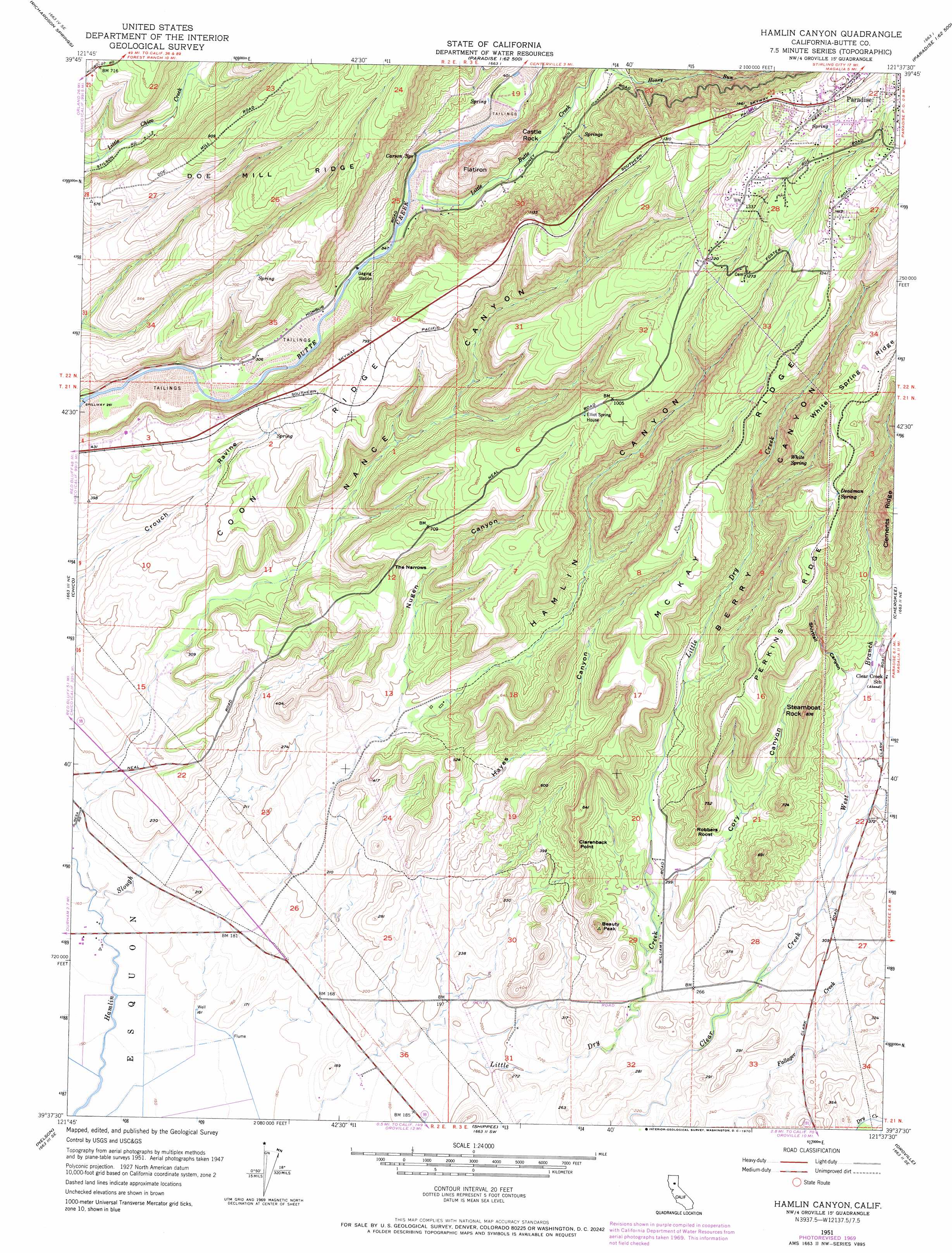
USGS Topo Quad 39121f6 - 1:24,000 scale
| Topo Map Name: | Hamlin Canyon |
| USGS Topo Quad ID: | 39121f6 |
| Print Size: | ca. 21 1/4" wide x 27" high |
| Southeast Coordinates: | 39.625° N latitude / 121.625° W longitude |
| Map Center Coordinates: | 39.6875° N latitude / 121.6875° W longitude |
| U.S. State: | CA |
| Filename: | o39121f6.jpg |
| Download Map JPG Image: | Hamlin Canyon topo map 1:24,000 scale |
| Map Type: | Topographic |
| Topo Series: | 7.5´ |
| Map Scale: | 1:24,000 |
| Source of Map Images: | United States Geological Survey (USGS) |
| Alternate Map Versions: |
Hamlin Canyon CA 1951, updated 1952 Download PDF Buy paper map Hamlin Canyon CA 1951, updated 1963 Download PDF Buy paper map Hamlin Canyon CA 1951, updated 1969 Download PDF Buy paper map Hamlin Canyon CA 1951, updated 1970 Download PDF Buy paper map Hamlin Canyon CA 1951, updated 1970 Download PDF Buy paper map Hamlin Canyon CA 2012 Download PDF Buy paper map Hamlin Canyon CA 2015 Download PDF Buy paper map |
1:24,000 Topo Quads surrounding Hamlin Canyon
Richardson Springs Nw |
Campbell Mound |
Cohasset |
Stirling City |
Kimshew Point |
Nord |
Richardson Springs |
Paradise West |
Paradise East |
Pulga |
Ord Ferry |
Chico |
Hamlin Canyon |
Cherokee |
Berry Creek |
Llano Seco |
Nelson |
Shippee |
Oroville |
Oroville Dam |
Butte City |
West Of Biggs |
Biggs |
Palermo |
Bangor |
> Back to 39121e1 at 1:100,000 scale
> Back to 39120a1 at 1:250,000 scale
> Back to U.S. Topo Maps home
Hamlin Canyon topo map: Gazetteer
Hamlin Canyon: Cliffs
Clarenback Point elevation 167m 547′Hamlin Canyon: Gaps
The Narrows elevation 183m 600′Hamlin Canyon: Ridges
Coon Ridge elevation 198m 649′McKay Ridge elevation 341m 1118′
Perkins Ridge elevation 300m 984′
Hamlin Canyon: Springs
Carson Spring elevation 119m 390′Deadman Spring elevation 332m 1089′
White Spring elevation 326m 1069′
Hamlin Canyon: Streams
Honey Run elevation 162m 531′Little Butte Creek elevation 104m 341′
West Branch Clear Creek elevation 84m 275′
Hamlin Canyon: Summits
Beauty Peak elevation 175m 574′Castle Rock elevation 246m 807′
Flatiron elevation 239m 784′
Robbers Roost elevation 153m 501′
Steamboat Rock elevation 238m 780′
Hamlin Canyon: Valleys
Berry Canyon elevation 133m 436′Cory Canyon elevation 84m 275′
Hamlin Canyon elevation 83m 272′
Hayes Canyon elevation 62m 203′
Nance Canyon elevation 73m 239′
Nugen Canyon elevation 85m 278′
Shirttail Canyon elevation 152m 498′
Hamlin Canyon digital topo map on disk
Buy this Hamlin Canyon topo map showing relief, roads, GPS coordinates and other geographical features, as a high-resolution digital map file on DVD: