Ord Ferry Topo Map California
To zoom in, hover over the map of Ord Ferry
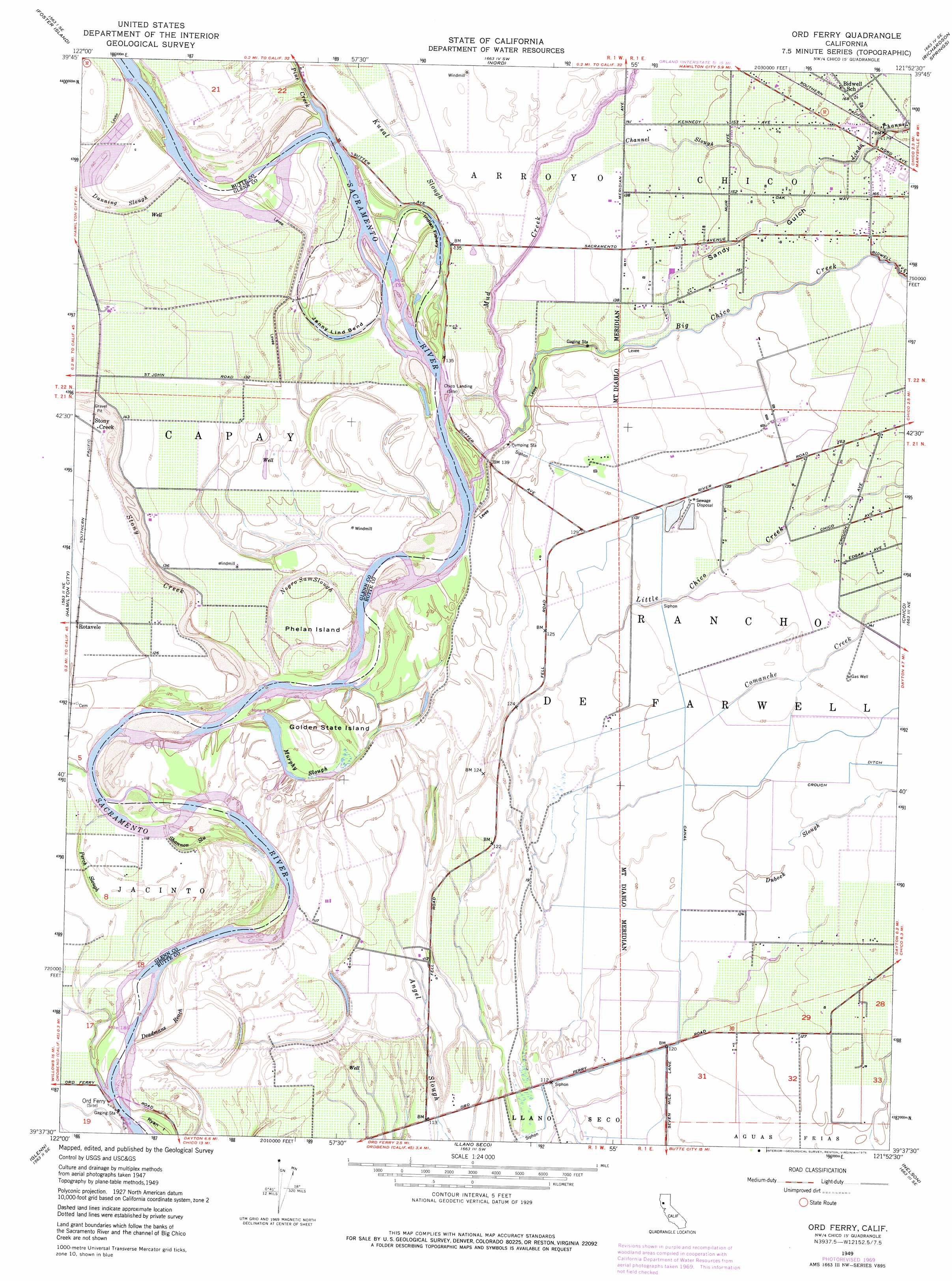
USGS Topo Quad 39121f8 - 1:24,000 scale
| Topo Map Name: | Ord Ferry |
| USGS Topo Quad ID: | 39121f8 |
| Print Size: | ca. 21 1/4" wide x 27" high |
| Southeast Coordinates: | 39.625° N latitude / 121.875° W longitude |
| Map Center Coordinates: | 39.6875° N latitude / 121.9375° W longitude |
| U.S. State: | CA |
| Filename: | o39121f8.jpg |
| Download Map JPG Image: | Ord Ferry topo map 1:24,000 scale |
| Map Type: | Topographic |
| Topo Series: | 7.5´ |
| Map Scale: | 1:24,000 |
| Source of Map Images: | United States Geological Survey (USGS) |
| Alternate Map Versions: |
Ord Ferry CA 1949, updated 1957 Download PDF Buy paper map Ord Ferry CA 1949, updated 1971 Download PDF Buy paper map Ord Ferry CA 1949, updated 1976 Download PDF Buy paper map Ord Ferry CA 1950 Download PDF Buy paper map Ord Ferry CA 2012 Download PDF Buy paper map Ord Ferry CA 2015 Download PDF Buy paper map |
1:24,000 Topo Quads surrounding Ord Ferry
Corning |
Vina |
Richardson Springs Nw |
Campbell Mound |
Cohasset |
Kirkwood |
Foster Island |
Nord |
Richardson Springs |
Paradise West |
Orland |
Hamilton City |
Ord Ferry |
Chico |
Hamlin Canyon |
Willows |
Glenn |
Llano Seco |
Nelson |
Shippee |
Logandale |
Princeton |
Butte City |
West Of Biggs |
Biggs |
> Back to 39121e1 at 1:100,000 scale
> Back to 39120a1 at 1:250,000 scale
> Back to U.S. Topo Maps home
Ord Ferry topo map: Gazetteer
Ord Ferry: Bends
Jenny Lind Bend elevation 36m 118′Ord Ferry: Guts
Deadmans Reach elevation 33m 108′Dunning Slough elevation 42m 137′
Perch Slough elevation 34m 111′
Shannon Slough elevation 34m 111′
Ord Ferry: Islands
Golden State Island elevation 39m 127′Phelan Island elevation 39m 127′
Ryan Island elevation 32m 104′
Ord Ferry: Lakes
Indian Fishery elevation 39m 127′Ord Ferry: Parks
Bidwell-Sacramento River State Park elevation 39m 127′Big Chico Creek Day Use Area elevation 40m 131′
Ordbend County Park elevation 36m 118′
Ord Ferry: Populated Places
Monroeville (historical) elevation 39m 127′Ord Ferry: Springs
Colyear Springs elevation 40m 131′Ord Ferry: Streams
Big Chico Creek elevation 39m 127′Channel Slough elevation 36m 118′
Comanche Creek elevation 40m 131′
Dubock Slough elevation 39m 127′
Kusal Slough elevation 36m 118′
Lindo Channel elevation 49m 160′
Mud Creek elevation 34m 111′
Murphy Slough elevation 39m 127′
Negro Sam Slough elevation 33m 108′
Pine Creek elevation 37m 121′
Stony Creek elevation 33m 108′
Ord Ferry: Valleys
Sandy Gulch elevation 42m 137′Ord Ferry digital topo map on disk
Buy this Ord Ferry topo map showing relief, roads, GPS coordinates and other geographical features, as a high-resolution digital map file on DVD: