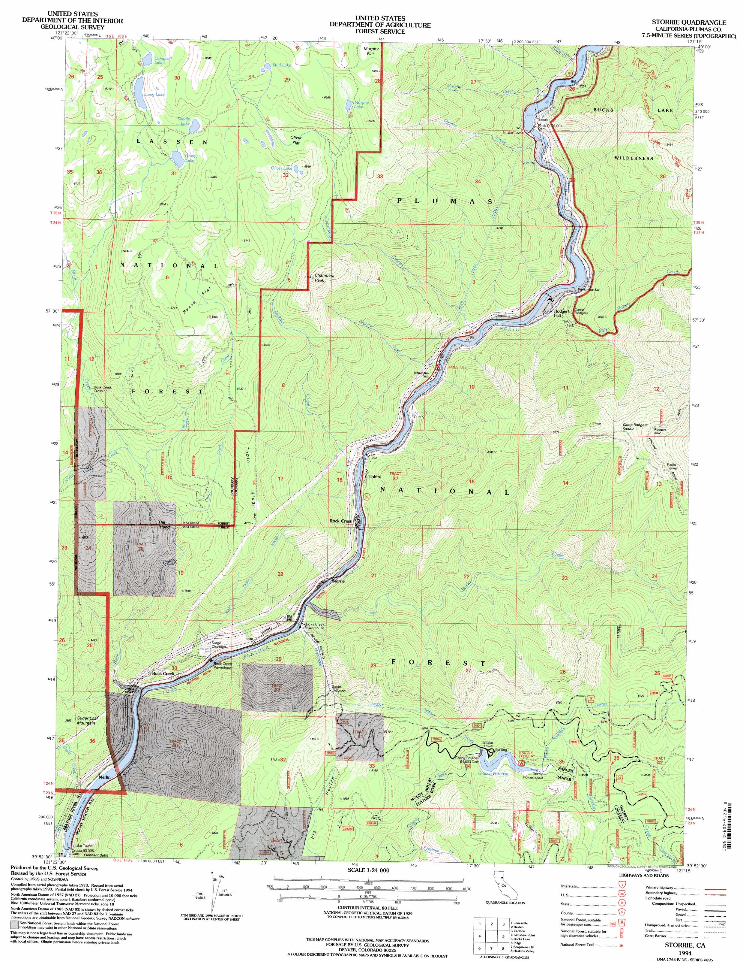
Storrie Topo Map California
To zoom in, hover over the map of Storrie
USGS Topo Quad 39121h3 - 1:24,000 scale
| Topo Map Name: | Storrie |
| USGS Topo Quad ID: | 39121h3 |
| Print Size: | ca. 21 1/4" wide x 27" high |
| Southeast Coordinates: | 39.875° N latitude / 121.25° W longitude |
| Map Center Coordinates: | 39.9375° N latitude / 121.3125° W longitude |
| U.S. State: | CA |
| Filename: | o39121h3.jpg |
| Download Map JPG Image: | Storrie topo map 1:24,000 scale |
| Map Type: | Topographic |
| Topo Series: | 7.5´ |
| Map Scale: | 1:24,000 |
| Source of Map Images: | United States Geological Survey (USGS) |
| Alternate Map Versions: |
Storrie CA 1979, updated 1980 Download PDF Buy paper map Storrie CA 1979, updated 1985 Download PDF Buy paper map Storrie CA 1994, updated 1998 Download PDF Buy paper map Storrie CA 2012 Download PDF Buy paper map Storrie CA 2015 Download PDF Buy paper map |
| FStopo: | US Forest Service topo Storrie is available: Download FStopo PDF Download FStopo TIF |
1:24,000 Topo Quads surrounding Storrie
Onion Butte |
Humboldt Peak |
Humbug Valley |
Almanor |
Canyondam |
Butte Meadows |
Jonesville |
Belden |
Caribou |
Twain |
Stirling City |
Kimshew Point |
Storrie |
Bucks Lake |
Meadow Valley |
Paradise East |
Pulga |
Soapstone Hill |
Haskins Valley |
Dogwood Peak |
Cherokee |
Berry Creek |
Brush Creek |
Cascade |
American House |
> Back to 39121e1 at 1:100,000 scale
> Back to 39120a1 at 1:250,000 scale
> Back to U.S. Topo Maps home
Storrie topo map: Gazetteer
Storrie: Airports
Rodgers Flat Heliport elevation 970m 3182′Storrie: Bars
Workmans Bar elevation 628m 2060′Storrie: Cliffs
Elephant Butte elevation 1072m 3517′Storrie: Crossings
Rock Creek Crossing elevation 1140m 3740′Rock Creek Crossing elevation 1228m 4028′
Storrie: Dams
Cresta Dam elevation 512m 1679′Grizzly Forebay 94-003 Dam elevation 1325m 4347′
Rock Creek Dam elevation 677m 2221′
Storrie: Flats
Murphy Flat elevation 1924m 6312′Oliver Flat elevation 1751m 5744′
Reese Flat elevation 1714m 5623′
Storrie: Gaps
Camp Rodgers Saddle elevation 1509m 4950′Storrie: Lakes
Campbell Lake elevation 1841m 6040′Grassy Lake elevation 1793m 5882′
Long Lake elevation 1818m 5964′
Mud Lake elevation 1873m 6145′
Murphy Lake elevation 1870m 6135′
Oliver Lake elevation 1842m 6043′
Saddle Lake elevation 1841m 6040′
Storrie: Populated Places
Merlin elevation 538m 1765′Rock Creek elevation 568m 1863′
Rock Creek Camp elevation 560m 1837′
Rock Crest elevation 573m 1879′
Rodgers Flat elevation 639m 2096′
Storrie elevation 544m 1784′
Tobin elevation 629m 2063′
Storrie: Post Offices
Camp Rogers Post Office (historical) elevation 651m 2135′Storrie: Reservoirs
Grizzly Forebay elevation 1325m 4347′Rock Creek Reservoir elevation 677m 2221′
Storrie: Ridges
Tobin Ridge elevation 1423m 4668′Storrie: Streams
Bucks Creek elevation 539m 1768′Cedar Creek elevation 513m 1683′
Chambers Creek elevation 613m 2011′
China Creek elevation 1080m 3543′
Chips Creek elevation 677m 2221′
Foreman Creek elevation 1191m 3907′
Granite Creek elevation 603m 1978′
Jackass Creek elevation 574m 1883′
Letterbox Creek elevation 1382m 4534′
Milk Ranch Creek elevation 625m 2050′
Murphy Creek elevation 676m 2217′
North Valley Creek elevation 1118m 3667′
Opapee Creek elevation 659m 2162′
Pauls Creek elevation 677m 2221′
Pine Creek elevation 1095m 3592′
Rock Creek elevation 513m 1683′
Swamp Creek elevation 513m 1683′
Storrie: Summits
Chambers Peak elevation 1858m 6095′Chambers Peak elevation 1838m 6030′
Sugar Loaf Mountain elevation 1080m 3543′
The Island elevation 1268m 4160′
Storrie: Tunnels
Tunnel 17 elevation 709m 2326′Storrie: Valleys
Grouse Hollow elevation 1185m 3887′Storrie digital topo map on disk
Buy this Storrie topo map showing relief, roads, GPS coordinates and other geographical features, as a high-resolution digital map file on DVD: