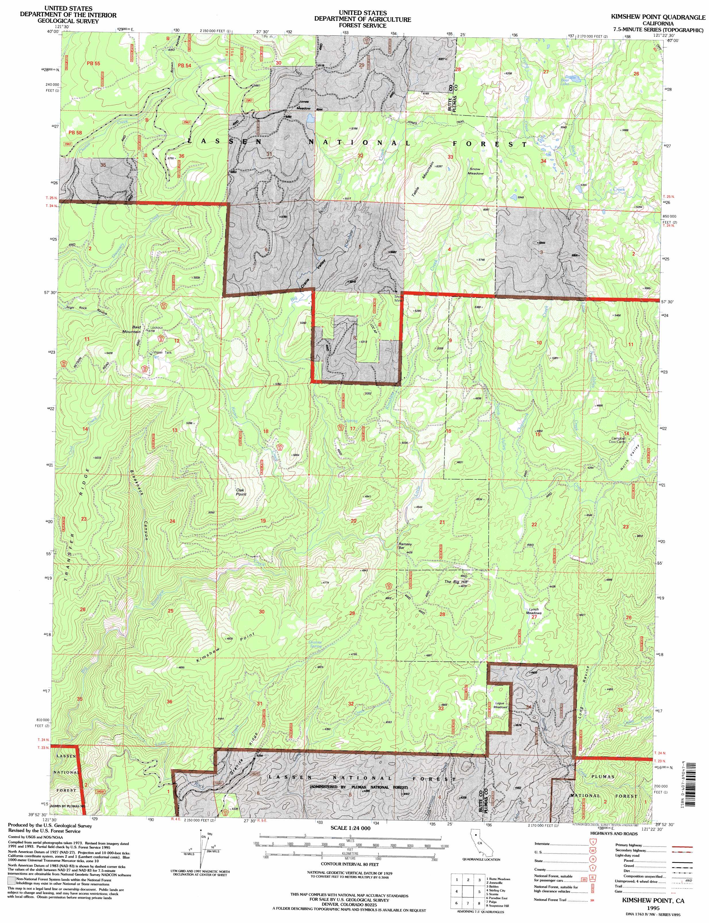
Kimshew Point Topo Map California
To zoom in, hover over the map of Kimshew Point
USGS Topo Quad 39121h4 - 1:24,000 scale
| Topo Map Name: | Kimshew Point |
| USGS Topo Quad ID: | 39121h4 |
| Print Size: | ca. 21 1/4" wide x 27" high |
| Southeast Coordinates: | 39.875° N latitude / 121.375° W longitude |
| Map Center Coordinates: | 39.9375° N latitude / 121.4375° W longitude |
| U.S. State: | CA |
| Filename: | o39121h4.jpg |
| Download Map JPG Image: | Kimshew Point topo map 1:24,000 scale |
| Map Type: | Topographic |
| Topo Series: | 7.5´ |
| Map Scale: | 1:24,000 |
| Source of Map Images: | United States Geological Survey (USGS) |
| Alternate Map Versions: |
Kimshew Point CA 1979, updated 1980 Download PDF Buy paper map Kimshew Point CA 1979, updated 1985 Download PDF Buy paper map Kimshew Point CA 1995, updated 1997 Download PDF Buy paper map Kimshew Point CA 2012 Download PDF Buy paper map Kimshew Point CA 2015 Download PDF Buy paper map |
| FStopo: | US Forest Service topo Kimshew Point is available: Download FStopo PDF Download FStopo TIF |
1:24,000 Topo Quads surrounding Kimshew Point
Barkley Mountain |
Onion Butte |
Humboldt Peak |
Humbug Valley |
Almanor |
Devils Parade Ground |
Butte Meadows |
Jonesville |
Belden |
Caribou |
Cohasset |
Stirling City |
Kimshew Point |
Storrie |
Bucks Lake |
Paradise West |
Paradise East |
Pulga |
Soapstone Hill |
Haskins Valley |
Hamlin Canyon |
Cherokee |
Berry Creek |
Brush Creek |
Cascade |
> Back to 39121e1 at 1:100,000 scale
> Back to 39120a1 at 1:250,000 scale
> Back to U.S. Topo Maps home
Kimshew Point topo map: Gazetteer
Kimshew Point: Areas
North Valley elevation 1298m 4258′Kimshew Point: Basins
Crane Valley elevation 1574m 5164′Kimshew Point: Capes
Kimshew Point elevation 1443m 4734′Kimshew Point: Flats
Jones Meadow elevation 1848m 6062′Logue Meadows elevation 1337m 4386′
Lynch Meadows elevation 1328m 4356′
Millers Meadow elevation 1575m 5167′
Snow Meadow elevation 1807m 5928′
Kimshew Point: Lakes
Bear Lake elevation 1729m 5672′Kimshew Point: Mines
Snow Mine elevation 1614m 5295′Kimshew Point: Ridges
Granite Ridge elevation 1344m 4409′Transfer Ridge elevation 1471m 4826′
Kimshew Point: Springs
Granite Spring elevation 1398m 4586′Kimshew Point: Streams
Chipmunk Creek elevation 1354m 4442′East Fork Last Chance Creek elevation 1571m 5154′
Frying Pan Creek elevation 1719m 5639′
Keyser Creek elevation 1239m 4064′
Little Kimshew Creek elevation 1231m 4038′
Little North Valley Creek elevation 1285m 4215′
Little Rock Creek elevation 870m 2854′
Kimshew Point: Summits
Bald Mountain elevation 1761m 5777′Oak Point elevation 1617m 5305′
Table Mountain elevation 1913m 6276′
The Big Hill elevation 1471m 4826′
Kimshew Point: Valleys
Breakneck Canyon elevation 1022m 3353′Brown Ravine elevation 1573m 5160′
Long Ravine elevation 1226m 4022′
Kimshew Point digital topo map on disk
Buy this Kimshew Point topo map showing relief, roads, GPS coordinates and other geographical features, as a high-resolution digital map file on DVD: