Stirling City Topo Map California
To zoom in, hover over the map of Stirling City
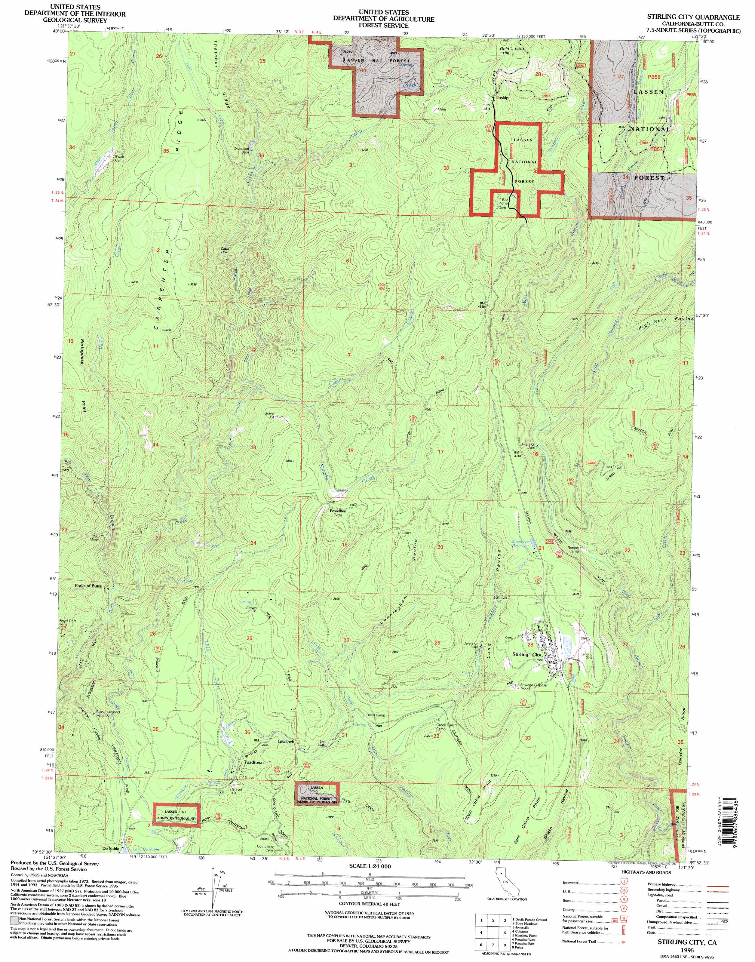
USGS Topo Quad 39121h5 - 1:24,000 scale
| Topo Map Name: | Stirling City |
| USGS Topo Quad ID: | 39121h5 |
| Print Size: | ca. 21 1/4" wide x 27" high |
| Southeast Coordinates: | 39.875° N latitude / 121.5° W longitude |
| Map Center Coordinates: | 39.9375° N latitude / 121.5625° W longitude |
| U.S. State: | CA |
| Filename: | o39121h5.jpg |
| Download Map JPG Image: | Stirling City topo map 1:24,000 scale |
| Map Type: | Topographic |
| Topo Series: | 7.5´ |
| Map Scale: | 1:24,000 |
| Source of Map Images: | United States Geological Survey (USGS) |
| Alternate Map Versions: |
Stirling City CA 1979, updated 1979 Download PDF Buy paper map Stirling City CA 1979, updated 1984 Download PDF Buy paper map Stirling City CA 1995, updated 1997 Download PDF Buy paper map Stirling City CA 2012 Download PDF Buy paper map Stirling City CA 2015 Download PDF Buy paper map |
| FStopo: | US Forest Service topo Stirling City is available: Download FStopo PDF Download FStopo TIF |
1:24,000 Topo Quads surrounding Stirling City
Panther Spring |
Barkley Mountain |
Onion Butte |
Humboldt Peak |
Humbug Valley |
Ishi Caves |
Devils Parade Ground |
Butte Meadows |
Jonesville |
Belden |
Campbell Mound |
Cohasset |
Stirling City |
Kimshew Point |
Storrie |
Richardson Springs |
Paradise West |
Paradise East |
Pulga |
Soapstone Hill |
Chico |
Hamlin Canyon |
Cherokee |
Berry Creek |
Brush Creek |
> Back to 39121e1 at 1:100,000 scale
> Back to 39120a1 at 1:250,000 scale
> Back to U.S. Topo Maps home
Stirling City topo map: Gazetteer
Stirling City: Flats
Jackass Flat elevation 1210m 3969′Stirling City: Mines
Black Diamond Mine elevation 792m 2598′Dix Mine elevation 708m 2322′
Royal Drift Mine elevation 744m 2440′
Stirling City: Populated Places
Inskip elevation 1456m 4776′Lovelock elevation 956m 3136′
Powellton elevation 1104m 3622′
Stirling City elevation 1088m 3569′
Toadtown elevation 848m 2782′
Stirling City: Reservoirs
Breedlove Reservoir elevation 1138m 3733′Stirling City: Ridges
Carpenter Ridge elevation 1094m 3589′Stirling City: Streams
Big Kimshew Creek elevation 755m 2477′Clear Creek elevation 751m 2463′
Cold Creek elevation 914m 2998′
Discovery Creek elevation 1274m 4179′
Fish Creek elevation 1018m 3339′
Haw Creek elevation 879m 2883′
Inskip Creek elevation 922m 3024′
Kanaka Creek elevation 1004m 3293′
Last Chance Creek elevation 999m 3277′
Varey Creek elevation 688m 2257′
West Branch Butte Creek elevation 642m 2106′
West Branch Fish Creek elevation 1274m 4179′
Stirling City: Summits
Cape Horn elevation 895m 2936′East China Point elevation 1038m 3405′
Gold Hill elevation 1523m 4996′
Portuguese Point elevation 1028m 3372′
West China Point elevation 1003m 3290′
Stirling City: Valleys
Blowhard Ravine elevation 1255m 4117′Boucher Ravine elevation 798m 2618′
Cunningham Ravine elevation 889m 2916′
High Rock Ravine elevation 1125m 3690′
Long Ravine elevation 839m 2752′
Stirling City digital topo map on disk
Buy this Stirling City topo map showing relief, roads, GPS coordinates and other geographical features, as a high-resolution digital map file on DVD: