Campbell Mound Topo Map California
To zoom in, hover over the map of Campbell Mound
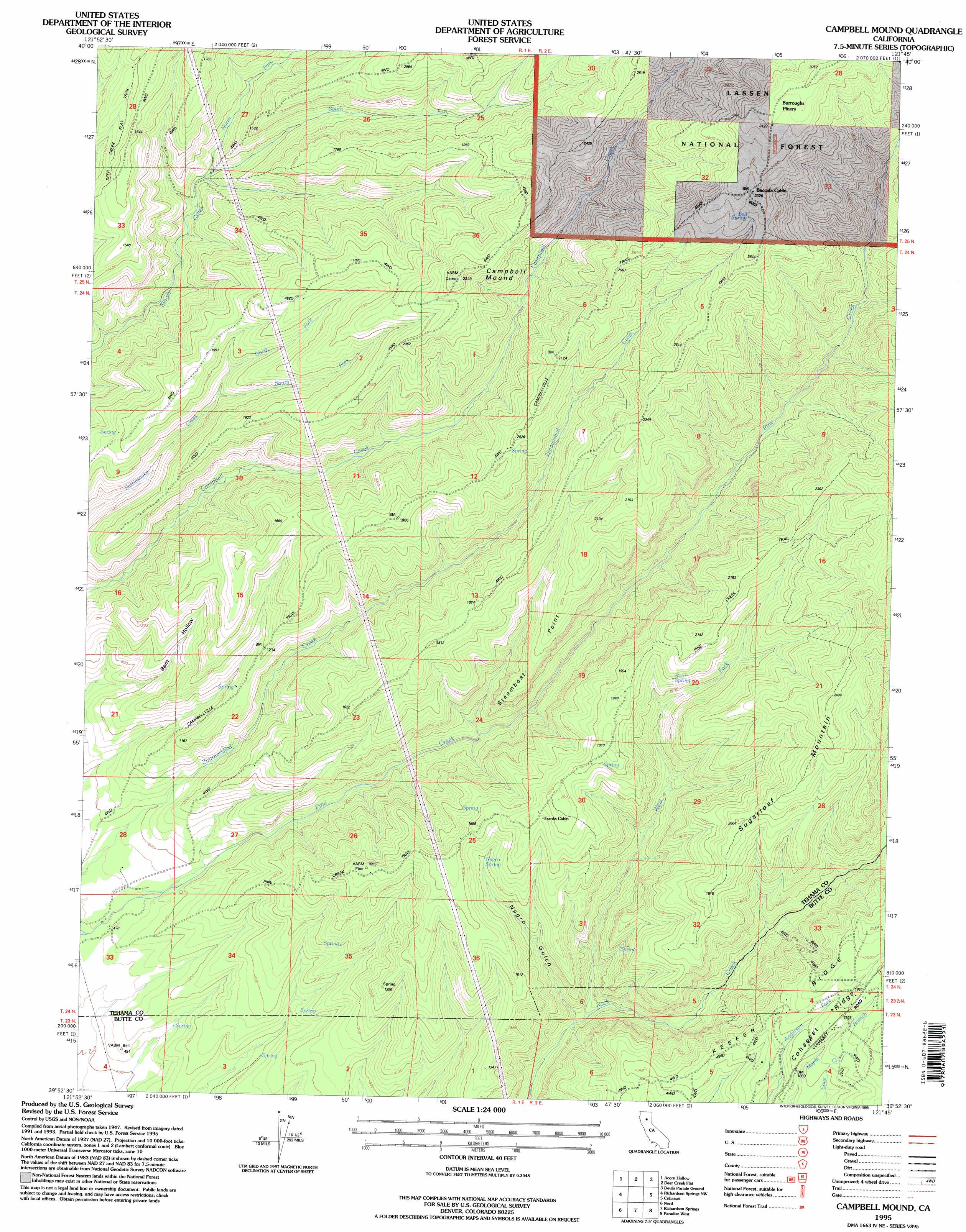
USGS Topo Quad 39121h7 - 1:24,000 scale
| Topo Map Name: | Campbell Mound |
| USGS Topo Quad ID: | 39121h7 |
| Print Size: | ca. 21 1/4" wide x 27" high |
| Southeast Coordinates: | 39.875° N latitude / 121.75° W longitude |
| Map Center Coordinates: | 39.9375° N latitude / 121.8125° W longitude |
| U.S. State: | CA |
| Filename: | o39121h7.jpg |
| Download Map JPG Image: | Campbell Mound topo map 1:24,000 scale |
| Map Type: | Topographic |
| Topo Series: | 7.5´ |
| Map Scale: | 1:24,000 |
| Source of Map Images: | United States Geological Survey (USGS) |
| Alternate Map Versions: |
Campbell Mound CA 1952, updated 1953 Download PDF Buy paper map Campbell Mound CA 1952, updated 1953 Download PDF Buy paper map Campbell Mound CA 1952, updated 1970 Download PDF Buy paper map Campbell Mound CA 1952, updated 1970 Download PDF Buy paper map Campbell Mound CA 1952, updated 1980 Download PDF Buy paper map Campbell Mound CA 1995, updated 1998 Download PDF Buy paper map Campbell Mound CA 2012 Download PDF Buy paper map Campbell Mound CA 2015 Download PDF Buy paper map |
| FStopo: | US Forest Service topo Campbell Mound is available: Download FStopo PDF Download FStopo TIF |
1:24,000 Topo Quads surrounding Campbell Mound
Tuscan Springs |
Dewitt Peak |
Panther Spring |
Barkley Mountain |
Onion Butte |
Los Molinos |
Acorn Hollow |
Ishi Caves |
Devils Parade Ground |
Butte Meadows |
Vina |
Richardson Springs Nw |
Campbell Mound |
Cohasset |
Stirling City |
Foster Island |
Nord |
Richardson Springs |
Paradise West |
Paradise East |
Hamilton City |
Ord Ferry |
Chico |
Hamlin Canyon |
Cherokee |
> Back to 39121e1 at 1:100,000 scale
> Back to 39120a1 at 1:250,000 scale
> Back to U.S. Topo Maps home
Campbell Mound topo map: Gazetteer
Campbell Mound: Basins
Barn Hollow elevation 306m 1003′Campbell Mound: Cliffs
Steamboat Point elevation 363m 1190′Campbell Mound: Ridges
Cohasset Ridge elevation 576m 1889′Keefer Ridge elevation 544m 1784′
Campbell Mound: Springs
Bell Spring elevation 872m 2860′Negro Spring elevation 434m 1423′
Root Spring elevation 544m 1784′
Campbell Mound: Streams
North Fork Rattlesnake Creek elevation 360m 1181′North Fork Singer Creek elevation 303m 994′
South Fork Rattlesnake Creek elevation 363m 1190′
South Fork Singer Creek elevation 301m 987′
West Fork Rock Creek elevation 219m 718′
Campbell Mound: Summits
Campbell Mound elevation 709m 2326′Sugarloaf Mountain elevation 757m 2483′
Campbell Mound: Trails
Campbellville Trail elevation 665m 2181′Pine Creek Trail elevation 663m 2175′
Campbell Mound: Valleys
Negro Gulch elevation 212m 695′Campbell Mound: Woods
Burroughs Pinery elevation 956m 3136′Campbell Mound digital topo map on disk
Buy this Campbell Mound topo map showing relief, roads, GPS coordinates and other geographical features, as a high-resolution digital map file on DVD: