Hull Mountain Topo Map California
To zoom in, hover over the map of Hull Mountain
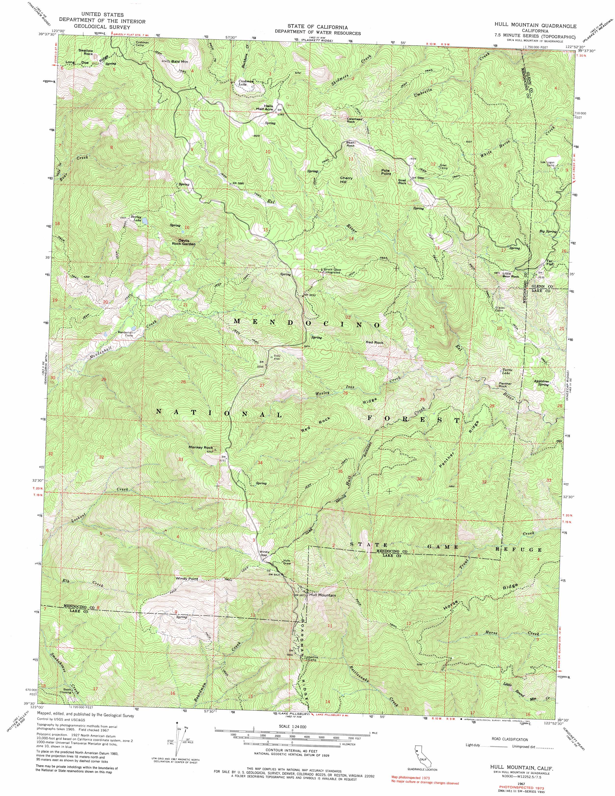
USGS Topo Quad 39122e8 - 1:24,000 scale
| Topo Map Name: | Hull Mountain |
| USGS Topo Quad ID: | 39122e8 |
| Print Size: | ca. 21 1/4" wide x 27" high |
| Southeast Coordinates: | 39.5° N latitude / 122.875° W longitude |
| Map Center Coordinates: | 39.5625° N latitude / 122.9375° W longitude |
| U.S. State: | CA |
| Filename: | o39122e8.jpg |
| Download Map JPG Image: | Hull Mountain topo map 1:24,000 scale |
| Map Type: | Topographic |
| Topo Series: | 7.5´ |
| Map Scale: | 1:24,000 |
| Source of Map Images: | United States Geological Survey (USGS) |
| Alternate Map Versions: |
Hull Mountain CA 1967, updated 1970 Download PDF Buy paper map Hull Mountain CA 1967, updated 1983 Download PDF Buy paper map Hull Mountain CA 1996, updated 2001 Download PDF Buy paper map Hull Mountain CA 2012 Download PDF Buy paper map Hull Mountain CA 2015 Download PDF Buy paper map |
| FStopo: | US Forest Service topo Hull Mountain is available: Download FStopo PDF Download FStopo TIF |
1:24,000 Topo Quads surrounding Hull Mountain
Covelo East |
Newhouse Ridge |
Mendocino Pass |
Log Spring |
Hall Ridge |
Jamison Ridge |
Thatcher Ridge |
Plaskett Ridge |
Plaskett Meadows |
Alder Springs |
Brushy Mountain |
Sanhedrin Mountain |
Hull Mountain |
Kneecap Ridge |
Felkner Hill |
Foster Mountain |
Van Arsdale Reservoir |
Lake Pillsbury |
Crockett Peak |
Saint John Mountain |
Redwood Valley |
Potter Valley |
Elk Mountain |
Potato Hill |
Fouts Springs |
> Back to 39122e1 at 1:100,000 scale
> Back to 39122a1 at 1:250,000 scale
> Back to U.S. Topo Maps home
Hull Mountain topo map: Gazetteer
Hull Mountain: Crossings
Booth Crossing elevation 851m 2791′Hull Mountain: Flats
Hells Half Acre elevation 1934m 6345′Tar Flat elevation 1434m 4704′
Hull Mountain: Gaps
Windy Gap elevation 1961m 6433′Hull Mountain: Lakes
Barley Lake elevation 1657m 5436′Cushman Lake elevation 1813m 5948′
Hull Mountain: Pillars
Bean Rock elevation 1822m 5977′Hull Mountain: Ridges
Devils Rock Garden elevation 1703m 5587′Horse Ridge elevation 1414m 4639′
Panther Ridge elevation 1348m 4422′
Red Rock Ridge elevation 1577m 5173′
Hull Mountain: Springs
Appletree Spring elevation 1188m 3897′Big Spring elevation 1413m 4635′
Chipmunk Spring elevation 1969m 6459′
Hull Mountain: Streams
Hull Creek elevation 1157m 3795′Wesley Ives Creek elevation 1162m 3812′
Hull Mountain: Summits
Bald Mountain elevation 2052m 6732′Calamese Rock elevation 1871m 6138′
Cherry Hill elevation 1871m 6138′
Goat Rock elevation 1826m 5990′
Hull Mountain elevation 2082m 6830′
Little Bear Rock elevation 1515m 4970′
Monkey Rock elevation 1930m 6332′
Panther Rock elevation 1183m 3881′
Pole Point elevation 1877m 6158′
Red Rock elevation 1479m 4852′
Swallow Rock elevation 1787m 5862′
Windy Point elevation 1810m 5938′
Hull Mountain digital topo map on disk
Buy this Hull Mountain topo map showing relief, roads, GPS coordinates and other geographical features, as a high-resolution digital map file on DVD: