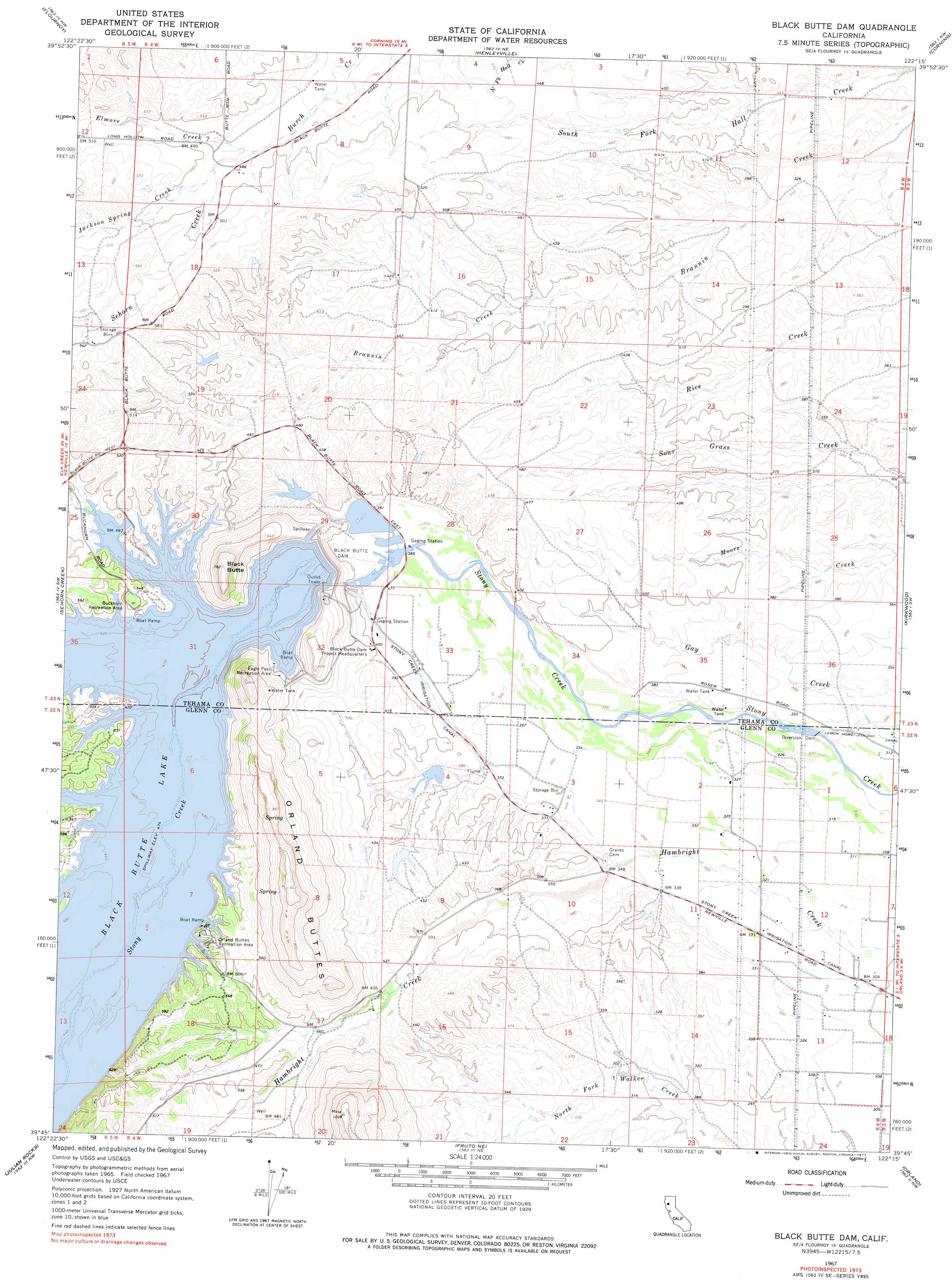
Black Butte Dam Topo Map California
To zoom in, hover over the map of Black Butte Dam
USGS Topo Quad 39122g3 - 1:24,000 scale
| Topo Map Name: | Black Butte Dam |
| USGS Topo Quad ID: | 39122g3 |
| Print Size: | ca. 21 1/4" wide x 27" high |
| Southeast Coordinates: | 39.75° N latitude / 122.25° W longitude |
| Map Center Coordinates: | 39.8125° N latitude / 122.3125° W longitude |
| U.S. State: | CA |
| Filename: | o39122g3.jpg |
| Download Map JPG Image: | Black Butte Dam topo map 1:24,000 scale |
| Map Type: | Topographic |
| Topo Series: | 7.5´ |
| Map Scale: | 1:24,000 |
| Source of Map Images: | United States Geological Survey (USGS) |
| Alternate Map Versions: |
Black Butte Dam CA 1967, updated 1968 Download PDF Buy paper map Black Butte Dam CA 1967, updated 1968 Download PDF Buy paper map Black Butte Dam CA 1967, updated 1977 Download PDF Buy paper map Black Butte Dam CA 2012 Download PDF Buy paper map Black Butte Dam CA 2015 Download PDF Buy paper map |
1:24,000 Topo Quads surrounding Black Butte Dam
Lowrey |
Red Bank |
West Of Gerber |
Gerber |
Los Molinos |
Paskenta |
Flournoy |
Henleyville |
Corning |
Vina |
Newville |
Sehorn Creek |
Black Butte Dam |
Kirkwood |
Foster Island |
Chrome |
Julian Rocks |
Fruto Ne |
Orland |
Hamilton City |
Elk Creek |
Fruto |
Stone Valley |
Willows |
Glenn |
> Back to 39122e1 at 1:100,000 scale
> Back to 39122a1 at 1:250,000 scale
> Back to U.S. Topo Maps home
Black Butte Dam topo map: Gazetteer
Black Butte Dam: Dams
Black Butte Dam elevation 147m 482′Black Butte Lake Dam elevation 145m 475′
Black Butte Dam: Parks
Buckhorn Recreation Area elevation 157m 515′Eagle Pass Recreation Area elevation 147m 482′
Lower Stony Creek Recreation Area elevation 114m 374′
Observation Point Recreation Area elevation 166m 544′
Orland Buttes Recreation Area elevation 160m 524′
South Canal Recreation Area elevation 110m 360′
Black Butte Dam: Reservoirs
Black Butte Lake elevation 156m 511′Black Butte Dam: Streams
Elmore Creek elevation 144m 472′Jackson Spring Creek elevation 145m 475′
Sehorn Creek elevation 147m 482′
Black Butte Dam: Summits
Black Butte elevation 240m 787′Orland Buttes elevation 290m 951′
Black Butte Dam digital topo map on disk
Buy this Black Butte Dam topo map showing relief, roads, GPS coordinates and other geographical features, as a high-resolution digital map file on DVD: