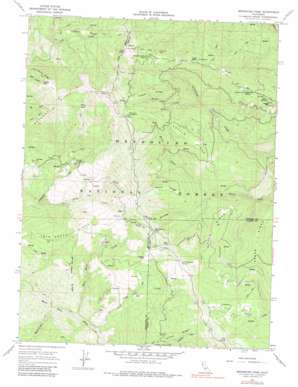
Mendocino Pass Topo Map California
To zoom in, hover over the map of Mendocino Pass
USGS Topo Quad 39122g8 - 1:24,000 scale
| Topo Map Name: | Mendocino Pass |
| USGS Topo Quad ID: | 39122g8 |
| Print Size: | ca. 21 1/4" wide x 27" high |
| Southeast Coordinates: | 39.75° N latitude / 122.875° W longitude |
| Map Center Coordinates: | 39.8125° N latitude / 122.9375° W longitude |
| U.S. State: | CA |
| Filename: | o39122g8.jpg |
| Download Map JPG Image: | Mendocino Pass topo map 1:24,000 scale |
| Map Type: | Topographic |
| Topo Series: | 7.5´ |
| Map Scale: | 1:24,000 |
| Source of Map Images: | United States Geological Survey (USGS) |
| Alternate Map Versions: |
Mendocino Pass CA 1967, updated 1970 Download PDF Buy paper map Mendocino Pass CA 1967, updated 1980 Download PDF Buy paper map Mendocino Pass CA 1996, updated 2001 Download PDF Buy paper map Mendocino Pass CA 2012 Download PDF Buy paper map Mendocino Pass CA 2015 Download PDF Buy paper map |
| FStopo: | US Forest Service topo Mendocino Pass is available: Download FStopo PDF Download FStopo TIF |
1:24,000 Topo Quads surrounding Mendocino Pass
> Back to 39122e1 at 1:100,000 scale
> Back to 39122a1 at 1:250,000 scale
> Back to U.S. Topo Maps home
Mendocino Pass topo map: Gazetteer
Mendocino Pass: Basins
Mare Basin elevation 1786m 5859′Mendocino Pass: Gaps
Mendocino Pass elevation 1519m 4983′Mendocino Pass: Populated Places
Bollinger Place elevation 1577m 5173′Bredehoft Place elevation 1431m 4694′
Hardy Place elevation 1401m 4596′
Mendocino Pass: Ridges
Board Ridge elevation 1553m 5095′Cattle Ridge elevation 1574m 5164′
Clifton Ridge elevation 1378m 4520′
Derby Ridge elevation 1895m 6217′
Espee Ridge elevation 1606m 5269′
Lake Ridge elevation 1397m 4583′
Recer Ridge elevation 1394m 4573′
Short Ridge elevation 1504m 4934′
Twin Rocks Ridge elevation 1318m 4324′
Mendocino Pass: Springs
Cold Spring elevation 1988m 6522′Lightning Spring elevation 1603m 5259′
Rock Spring elevation 1628m 5341′
Seven Troughs Spring elevation 1656m 5433′
Sugar Spring elevation 1655m 5429′
Mendocino Pass: Streams
Blue Slide Creek elevation 631m 2070′Burnt Creek elevation 1254m 4114′
Mississippi Creek elevation 592m 1942′
Twin Rocks Creek elevation 745m 2444′
White Hawk Creek elevation 614m 2014′
Mendocino Pass: Summits
Anthony Peak elevation 2115m 6938′Little Baldy elevation 1810m 5938′
Oak Knoll elevation 1603m 5259′
Uhl Peak elevation 2020m 6627′
Mendocino Pass: Trails
Buttermilk Trail elevation 1077m 3533′Mendocino Pass digital topo map on disk
Buy this Mendocino Pass topo map showing relief, roads, GPS coordinates and other geographical features, as a high-resolution digital map file on DVD:


