Ball Mountain Topo Map California
To zoom in, hover over the map of Ball Mountain
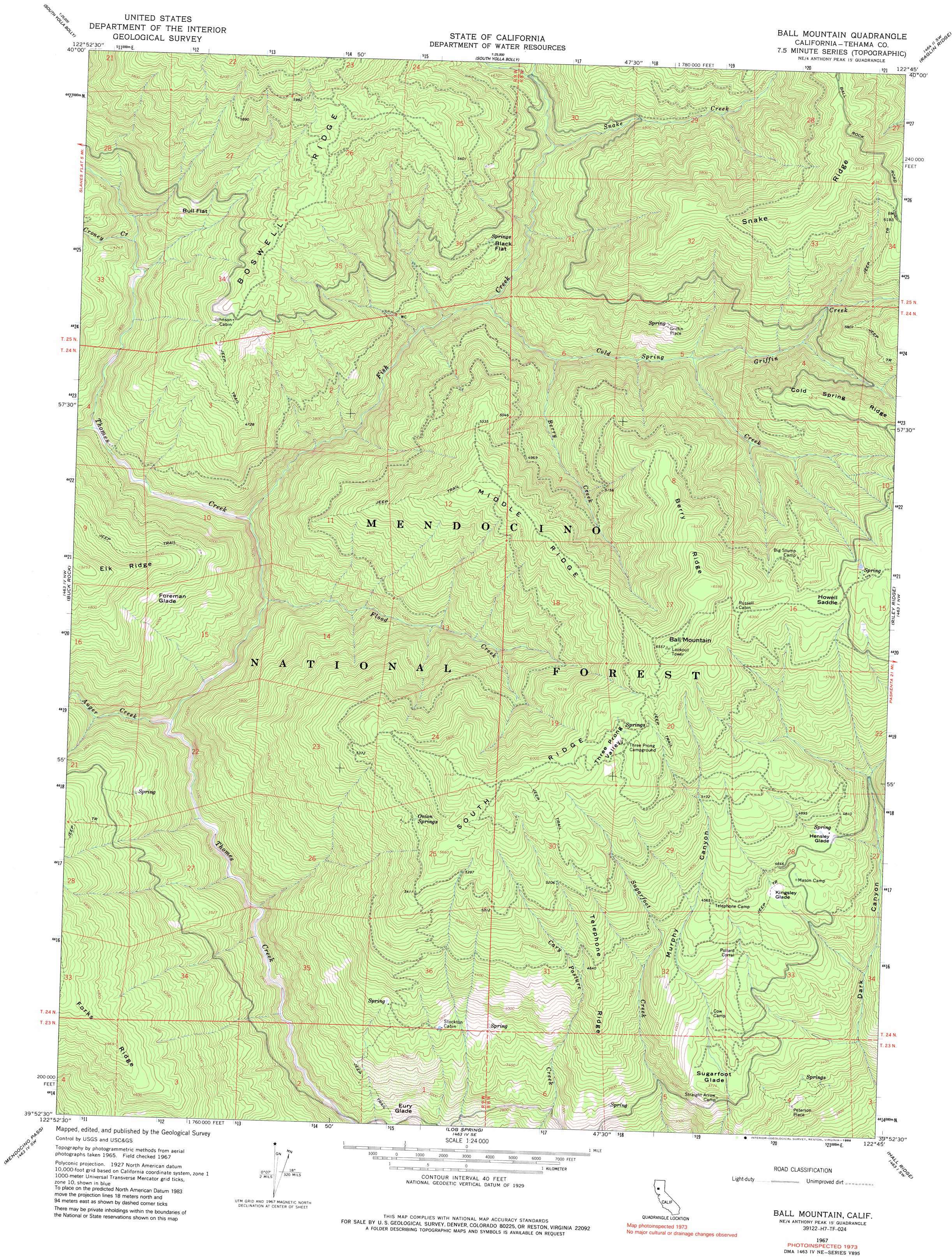
USGS Topo Quad 39122h7 - 1:24,000 scale
| Topo Map Name: | Ball Mountain |
| USGS Topo Quad ID: | 39122h7 |
| Print Size: | ca. 21 1/4" wide x 27" high |
| Southeast Coordinates: | 39.875° N latitude / 122.75° W longitude |
| Map Center Coordinates: | 39.9375° N latitude / 122.8125° W longitude |
| U.S. State: | CA |
| Filename: | o39122h7.jpg |
| Download Map JPG Image: | Ball Mountain topo map 1:24,000 scale |
| Map Type: | Topographic |
| Topo Series: | 7.5´ |
| Map Scale: | 1:24,000 |
| Source of Map Images: | United States Geological Survey (USGS) |
| Alternate Map Versions: |
Ball Mountain CA 1967, updated 1970 Download PDF Buy paper map Ball Mountain CA 1967, updated 1970 Download PDF Buy paper map Ball Mountain CA 1967, updated 1975 Download PDF Buy paper map Ball Mountain CA 1967, updated 1986 Download PDF Buy paper map Ball Mountain CA 1996, updated 2001 Download PDF Buy paper map Ball Mountain CA 2012 Download PDF Buy paper map Ball Mountain CA 2015 Download PDF Buy paper map |
| FStopo: | US Forest Service topo Ball Mountain is available: Download FStopo PDF Download FStopo TIF |
1:24,000 Topo Quads surrounding Ball Mountain
Black Rock Mountain |
Tomhead Mountain |
Cold Fork |
Oxbow Bridge |
|
Wrights Ridge |
South Yolla Bolly Mountains |
Raglin Ridge |
Lowrey |
|
Leech Lake Mountain |
Buck Rock |
Ball Mountain |
Riley Ridge |
Paskenta |
Newhouse Ridge |
Mendocino Pass |
Log Spring |
Hall Ridge |
Newville |
Thatcher Ridge |
Plaskett Ridge |
Plaskett Meadows |
Alder Springs |
Chrome |
> Back to 39122e1 at 1:100,000 scale
> Back to 39122a1 at 1:250,000 scale
> Back to U.S. Topo Maps home
Ball Mountain topo map: Gazetteer
Ball Mountain: Basins
Three Prong Valley elevation 1800m 5905′Ball Mountain: Flats
Black Flat elevation 1320m 4330′Bull Flat elevation 1368m 4488′
Eury Glade elevation 818m 2683′
Foreman Glade elevation 1298m 4258′
Hensley Glade elevation 1430m 4691′
Kingsley Glade elevation 1363m 4471′
Sugarfoot Glade elevation 1146m 3759′
Ball Mountain: Gaps
Howell Gap elevation 1881m 6171′Ball Mountain: Populated Places
Griffin Place elevation 1448m 4750′Peterson Place elevation 959m 3146′
Ball Mountain: Ridges
Berry Ridge elevation 1931m 6335′Boswell Ridge elevation 1764m 5787′
Cold Spring Ridge elevation 1807m 5928′
Middle Ridge elevation 1772m 5813′
Snake Ridge elevation 1940m 6364′
South Ridge elevation 1871m 6138′
Telephone Ridge elevation 1411m 4629′
Ball Mountain: Springs
Onion Springs elevation 1636m 5367′Ball Mountain: Streams
Auger Creek elevation 898m 2946′Berry Creek elevation 1203m 3946′
Cold Spring Creek elevation 1133m 3717′
Croney Creek elevation 1162m 3812′
Fish Creek elevation 979m 3211′
Flood Creek elevation 962m 3156′
Griffin Creek elevation 1329m 4360′
McClure Creek elevation 1034m 3392′
Snake Creek elevation 1298m 4258′
Ball Mountain: Summits
Ball Mountain elevation 1993m 6538′Ball Mountain digital topo map on disk
Buy this Ball Mountain topo map showing relief, roads, GPS coordinates and other geographical features, as a high-resolution digital map file on DVD: