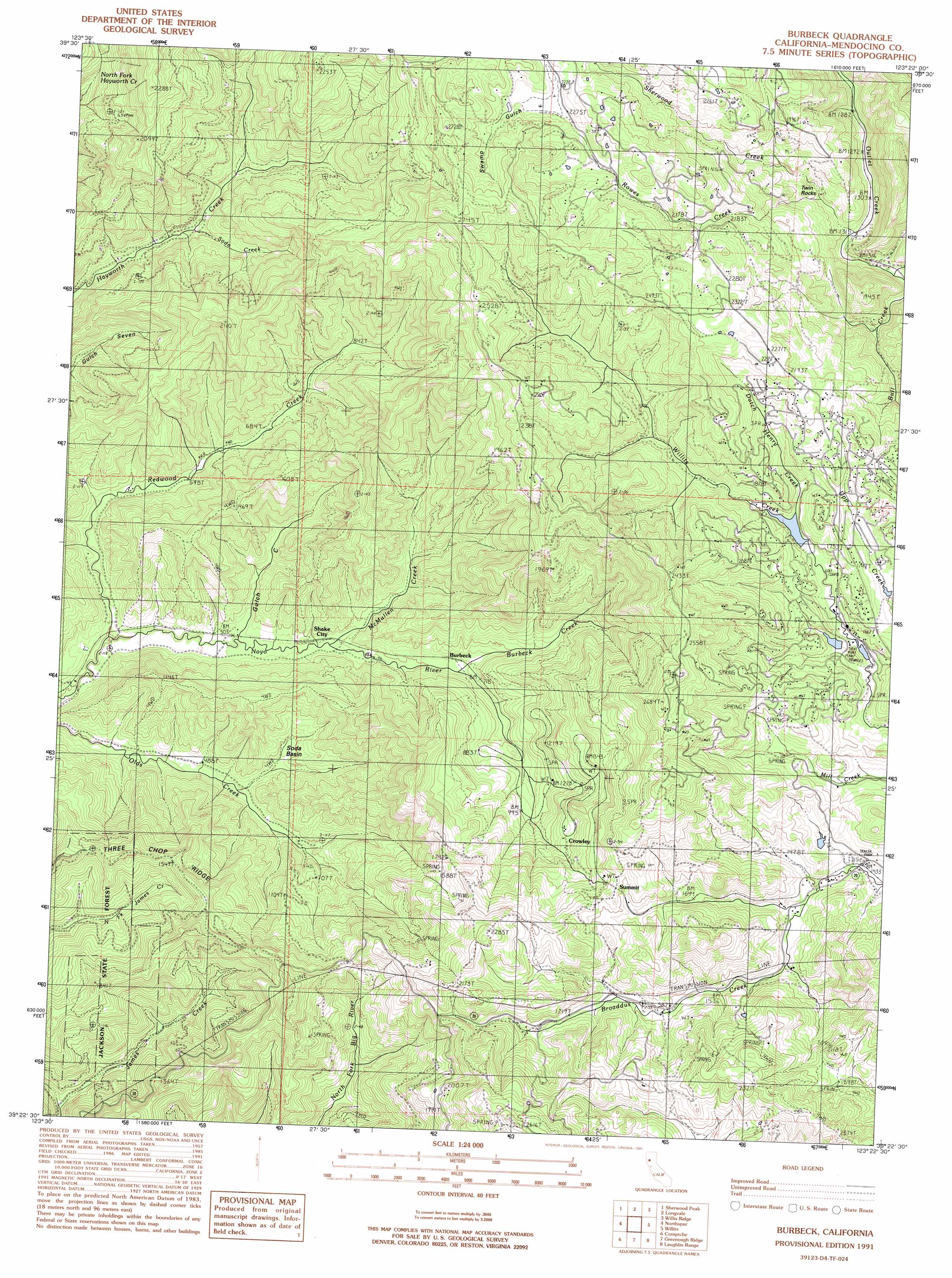
Burbeck Topo Map California
To zoom in, hover over the map of Burbeck
USGS Topo Quad 39123d4 - 1:24,000 scale
| Topo Map Name: | Burbeck |
| USGS Topo Quad ID: | 39123d4 |
| Print Size: | ca. 21 1/4" wide x 27" high |
| Southeast Coordinates: | 39.375° N latitude / 123.375° W longitude |
| Map Center Coordinates: | 39.4375° N latitude / 123.4375° W longitude |
| U.S. State: | CA |
| Filename: | o39123d4.jpg |
| Download Map JPG Image: | Burbeck topo map 1:24,000 scale |
| Map Type: | Topographic |
| Topo Series: | 7.5´ |
| Map Scale: | 1:24,000 |
| Source of Map Images: | United States Geological Survey (USGS) |
| Alternate Map Versions: |
Burbeck CA 1991, updated 1991 Download PDF Buy paper map Burbeck CA 2012 Download PDF Buy paper map Burbeck CA 2015 Download PDF Buy paper map |
1:24,000 Topo Quads surrounding Burbeck
Lincoln Ridge |
Cahto Peak |
Laytonville |
Dos Rios |
Jamison Ridge |
Dutchmans Knoll |
Sherwood Peak |
Longvale |
Willis Ridge |
Brushy Mountain |
Noyo Hill |
Northspur |
Burbeck |
Willits |
Foster Mountain |
Mathison Peak |
Comptche |
Greenough Ridge |
Laughlin Range |
Redwood Valley |
Elk |
Navarro |
Bailey Ridge |
Orrs Springs |
Ukiah |
> Back to 39123a1 at 1:100,000 scale
> Back to 39122a1 at 1:250,000 scale
> Back to U.S. Topo Maps home
Burbeck topo map: Gazetteer
Burbeck: Basins
Soda Basin elevation 179m 587′Burbeck: Dams
Brooktrails Number 3 N 1038-003 Dam elevation 471m 1545′Lake Ada Rose 1038 Dam elevation 465m 1525′
Burbeck: Populated Places
Brooktrails elevation 498m 1633′Burbeck elevation 199m 652′
Clare Mill elevation 293m 961′
Crowley elevation 377m 1236′
Rowes (historical) elevation 658m 2158′
Shake City elevation 161m 528′
Soda Springs elevation 226m 741′
Sylvandale (historical) elevation 688m 2257′
Burbeck: Reservoirs
Lake Ada Rose elevation 465m 1525′Lake Emily elevation 471m 1545′
Summer Lake elevation 454m 1489′
Burbeck: Streams
Bull Creek elevation 475m 1558′Burbeck Creek elevation 221m 725′
Dutch Henry Creek elevation 494m 1620′
Gulch Creek elevation 148m 485′
McMullen Creek elevation 161m 528′
Redwood Creek elevation 124m 406′
Rowes Creek elevation 469m 1538′
Ryan Creek elevation 470m 1541′
Sherwood Creek elevation 445m 1459′
Soda Creek elevation 219m 718′
Burbeck: Summits
Twin Rocks elevation 547m 1794′Burbeck: Trails
Cat Trail elevation 495m 1624′Fawn Lily Trail elevation 498m 1633′
Gooseberry Trail elevation 525m 1722′
Inlet Trail elevation 516m 1692′
Meadowlark Trail elevation 600m 1968′
Nutmeg Trail elevation 452m 1482′
Oregon Grape Trail elevation 488m 1601′
Tan Bark Trail elevation 619m 2030′
Burbeck: Valleys
Swamp Gulch elevation 694m 2276′Burbeck digital topo map on disk
Buy this Burbeck topo map showing relief, roads, GPS coordinates and other geographical features, as a high-resolution digital map file on DVD: