Noyo Hill Topo Map California
To zoom in, hover over the map of Noyo Hill
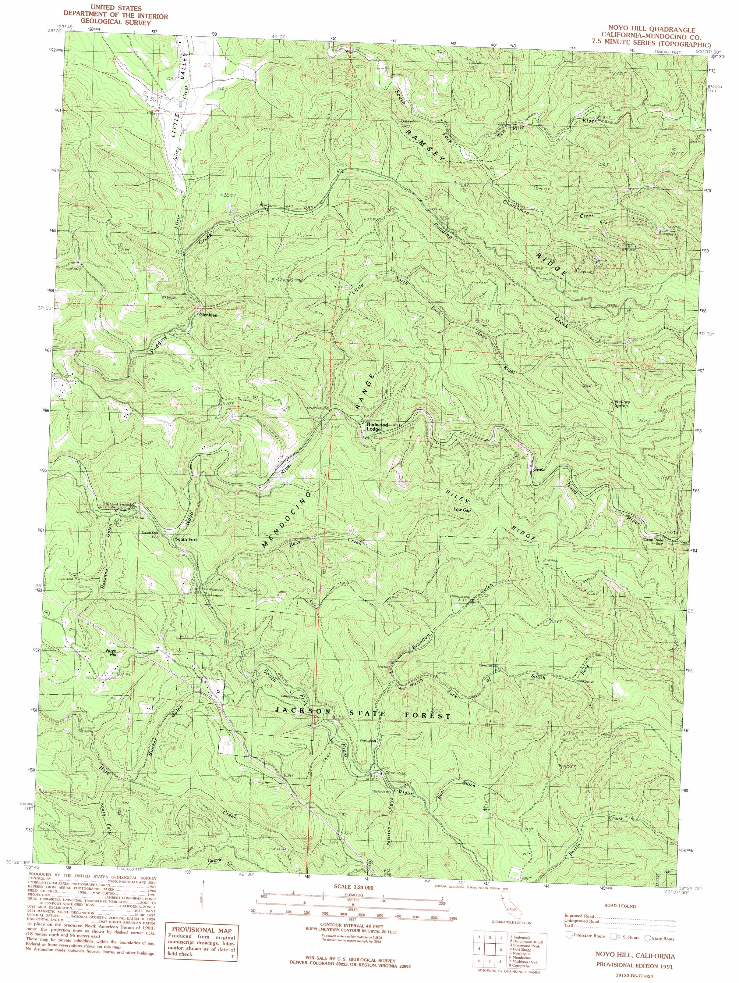
USGS Topo Quad 39123d6 - 1:24,000 scale
| Topo Map Name: | Noyo Hill |
| USGS Topo Quad ID: | 39123d6 |
| Print Size: | ca. 21 1/4" wide x 27" high |
| Southeast Coordinates: | 39.375° N latitude / 123.625° W longitude |
| Map Center Coordinates: | 39.4375° N latitude / 123.6875° W longitude |
| U.S. State: | CA |
| Filename: | o39123d6.jpg |
| Download Map JPG Image: | Noyo Hill topo map 1:24,000 scale |
| Map Type: | Topographic |
| Topo Series: | 7.5´ |
| Map Scale: | 1:24,000 |
| Source of Map Images: | United States Geological Survey (USGS) |
| Alternate Map Versions: |
Noyo Hill CA 1991, updated 1991 Download PDF Buy paper map Noyo Hill CA 2012 Download PDF Buy paper map Noyo Hill CA 2015 Download PDF Buy paper map |
1:24,000 Topo Quads surrounding Noyo Hill
Westport |
Lincoln Ridge |
Cahto Peak |
Laytonville |
|
Inglenook |
Dutchmans Knoll |
Sherwood Peak |
Longvale |
|
Fort Bragg |
Noyo Hill |
Northspur |
Burbeck |
|
Mendocino |
Mathison Peak |
Comptche |
Greenough Ridge |
|
Albion |
Elk |
Navarro |
Bailey Ridge |
> Back to 39123a1 at 1:100,000 scale
> Back to 39122a1 at 1:250,000 scale
> Back to U.S. Topo Maps home
Noyo Hill topo map: Gazetteer
Noyo Hill: Basins
Little Valley elevation 43m 141′Noyo Hill: Gaps
Low Gap elevation 318m 1043′Noyo Hill: Parks
Jackson State Forest elevation 322m 1056′Noyo Hill: Populated Places
Glenblair elevation 63m 206′Grove elevation 123m 403′
Redwood Lodge elevation 20m 65′
South Fork elevation 14m 45′
Noyo Hill: Ridges
Ramsey Ridge elevation 256m 839′Riley Ridge elevation 333m 1092′
Noyo Hill: Springs
Mallory Spring elevation 318m 1043′Noyo Hill: Streams
Churchman Creek elevation 53m 173′Kass Creek elevation 12m 39′
Little North Fork Noyo River elevation 115m 377′
Little Valley Creek elevation 44m 144′
North Fork South Fork Noyo River elevation 36m 118′
South Fork Hare Creek elevation 66m 216′
South Fork Noyo River elevation 35m 114′
Noyo Hill: Summits
Noyo Hill elevation 248m 813′Noyo Hill: Valleys
Bear Gulch elevation 78m 255′Brandon Gulch elevation 87m 285′
Bunker Gulch elevation 71m 232′
Camp Eight Gulch elevation 85m 278′
Camp Four Gulch elevation 71m 232′
Camp Three Gulch elevation 48m 157′
Hayshed Gulch elevation 11m 36′
Lake Gulch elevation 159m 521′
Peterson Gulch elevation 50m 164′
Noyo Hill digital topo map on disk
Buy this Noyo Hill topo map showing relief, roads, GPS coordinates and other geographical features, as a high-resolution digital map file on DVD: