Inglenook Topo Map California
To zoom in, hover over the map of Inglenook
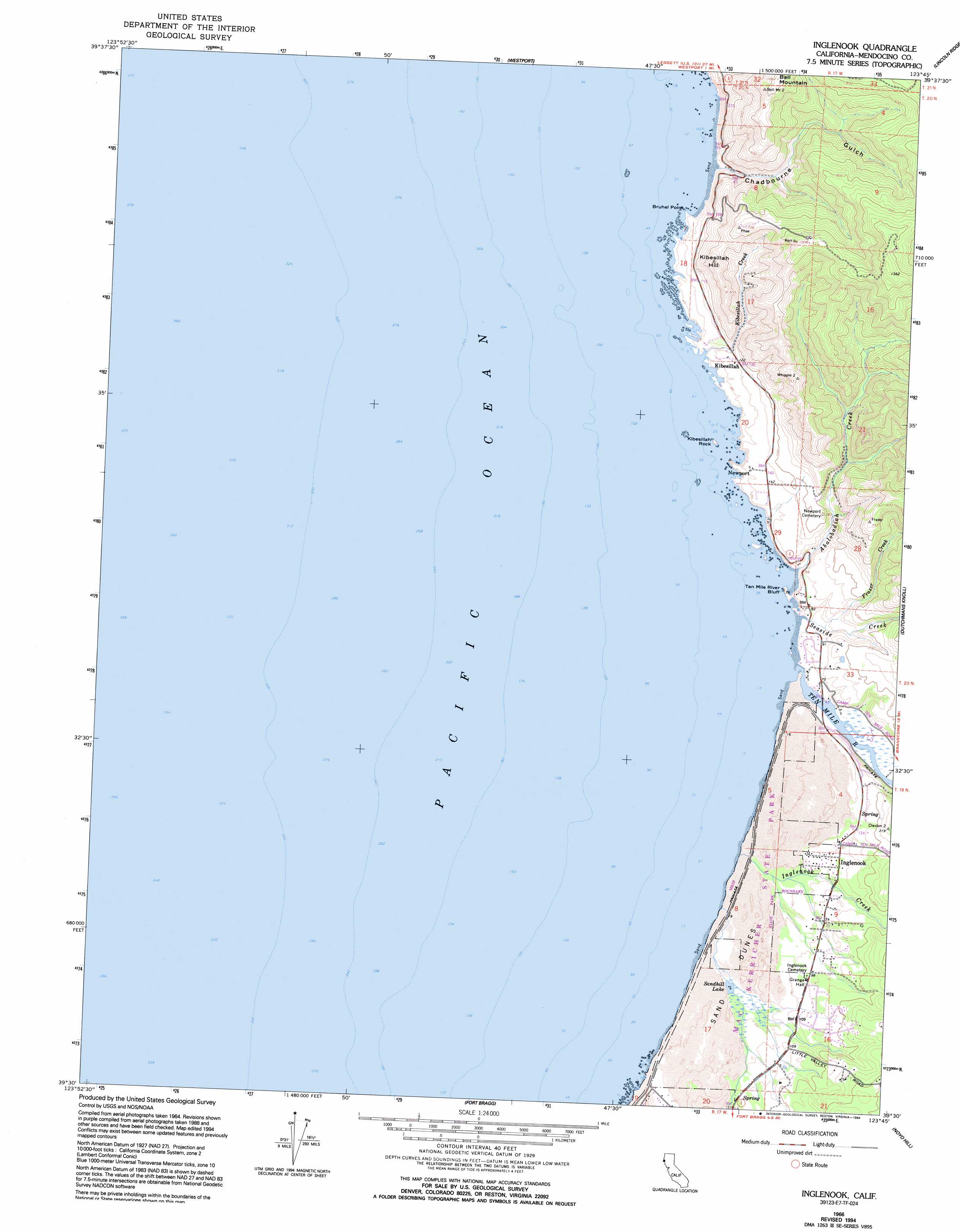
USGS Topo Quad 39123e7 - 1:24,000 scale
| Topo Map Name: | Inglenook |
| USGS Topo Quad ID: | 39123e7 |
| Print Size: | ca. 21 1/4" wide x 27" high |
| Southeast Coordinates: | 39.5° N latitude / 123.75° W longitude |
| Map Center Coordinates: | 39.5625° N latitude / 123.8125° W longitude |
| U.S. State: | CA |
| Filename: | o39123e7.jpg |
| Download Map JPG Image: | Inglenook topo map 1:24,000 scale |
| Map Type: | Topographic |
| Topo Series: | 7.5´ |
| Map Scale: | 1:24,000 |
| Source of Map Images: | United States Geological Survey (USGS) |
| Alternate Map Versions: |
Inglenook CA 1966, updated 1968 Download PDF Buy paper map Inglenook CA 1966, updated 1980 Download PDF Buy paper map Inglenook CA 1966, updated 1992 Download PDF Buy paper map Inglenook CA 1966, updated 1994 Download PDF Buy paper map Inglenook CA 2012 Download PDF Buy paper map Inglenook CA 2015 Download PDF Buy paper map |
1:24,000 Topo Quads surrounding Inglenook
Mistake Point |
Hales Grove |
Leggett |
Tan Oak Park |
|
Westport |
Lincoln Ridge |
Cahto Peak |
||
Inglenook |
Dutchmans Knoll |
Sherwood Peak |
||
Fort Bragg |
Noyo Hill |
Northspur |
||
Mendocino |
Mathison Peak |
Comptche |
> Back to 39123e1 at 1:100,000 scale
> Back to 39122a1 at 1:250,000 scale
> Back to U.S. Topo Maps home
Inglenook topo map: Gazetteer
Inglenook: Areas
Ten Mile Dunes elevation 12m 39′Inglenook: Beaches
Seaside Creek Beach elevation 1m 3′Ten Mile Beach elevation 1m 3′
Inglenook: Capes
Bruhel Point elevation 1m 3′Ten Mile River Bluff elevation 20m 65′
Inglenook: Islands
Kibesillah Rock elevation 0m 0′Inglenook: Lakes
Sandhill Lake elevation 8m 26′Inglenook: Populated Places
Inglenook elevation 31m 101′Kibesillah elevation 42m 137′
Newport elevation 41m 134′
Inglenook: Streams
Abalobadiah Creek elevation 0m 0′Frazer Creek elevation 11m 36′
Inglenook Creek elevation 1m 3′
Kibesillah Creek elevation 12m 39′
Seaside Creek elevation 13m 42′
Ten Mile River elevation 0m 0′
Inglenook: Summits
Bell Mountain elevation 321m 1053′Kibesillah Hill elevation 184m 603′
Inglenook: Swamps
Inglenook Fen elevation 7m 22′Inglenook: Valleys
Chadbourne Gulch elevation 4m 13′Inglenook digital topo map on disk
Buy this Inglenook topo map showing relief, roads, GPS coordinates and other geographical features, as a high-resolution digital map file on DVD: