Noble Butte Topo Map California
To zoom in, hover over the map of Noble Butte
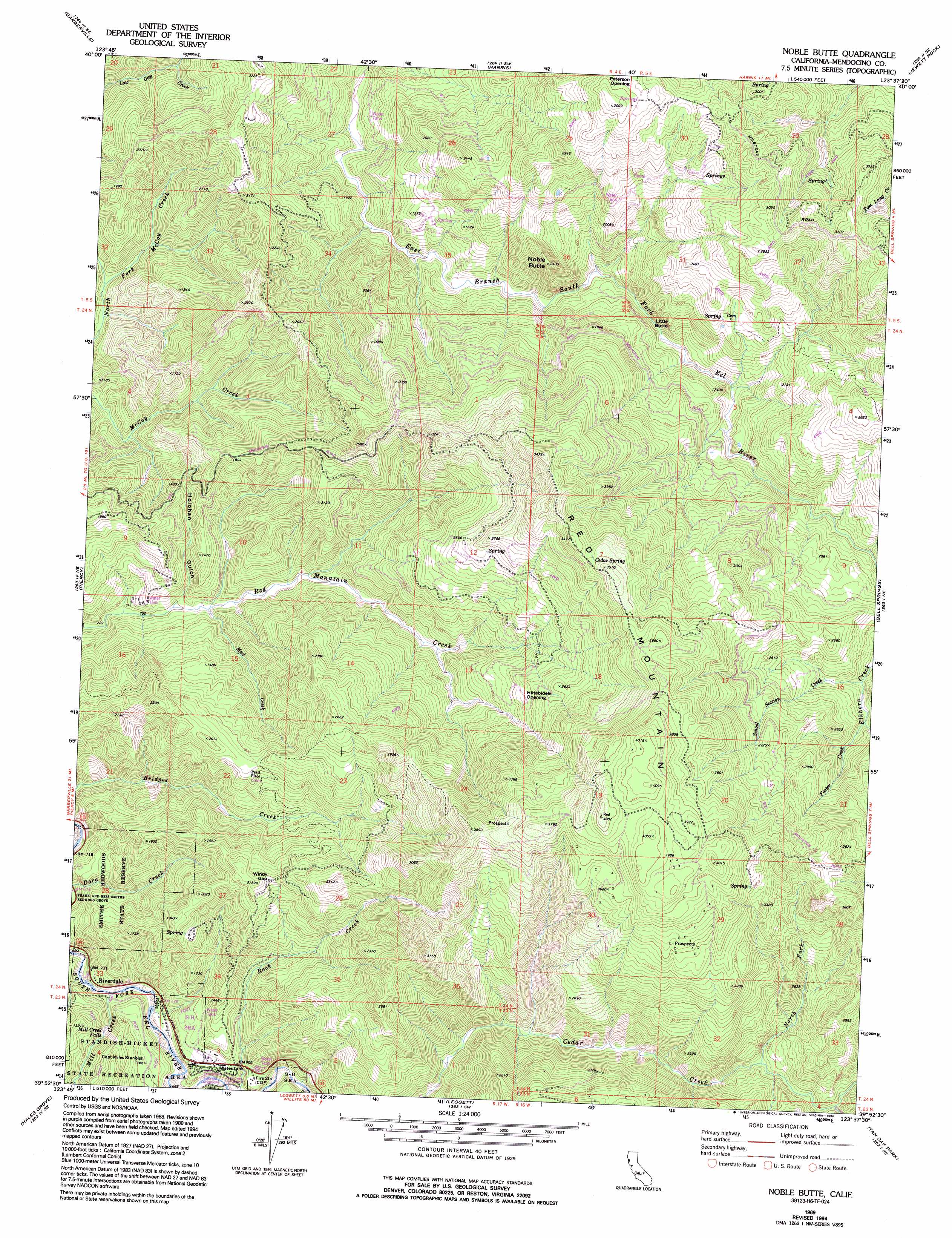
USGS Topo Quad 39123h6 - 1:24,000 scale
| Topo Map Name: | Noble Butte |
| USGS Topo Quad ID: | 39123h6 |
| Print Size: | ca. 21 1/4" wide x 27" high |
| Southeast Coordinates: | 39.875° N latitude / 123.625° W longitude |
| Map Center Coordinates: | 39.9375° N latitude / 123.6875° W longitude |
| U.S. State: | CA |
| Filename: | o39123h6.jpg |
| Download Map JPG Image: | Noble Butte topo map 1:24,000 scale |
| Map Type: | Topographic |
| Topo Series: | 7.5´ |
| Map Scale: | 1:24,000 |
| Source of Map Images: | United States Geological Survey (USGS) |
| Alternate Map Versions: |
Noble Butte CA 1969, updated 1974 Download PDF Buy paper map Noble Butte CA 1969, updated 1994 Download PDF Buy paper map Noble Butte CA 2012 Download PDF Buy paper map Noble Butte CA 2015 Download PDF Buy paper map |
1:24,000 Topo Quads surrounding Noble Butte
Ettersburg |
Miranda |
Fort Seward |
Alderpoint |
Zenia |
Briceland |
Garberville |
Harris |
Jewett Rock |
Lake Mountain |
Bear Harbor |
Piercy |
Noble Butte |
Bell Springs |
Updegraff Ridge |
Mistake Point |
Hales Grove |
Leggett |
Tan Oak Park |
Iron Peak |
Westport |
Lincoln Ridge |
Cahto Peak |
Laytonville |
> Back to 39123e1 at 1:100,000 scale
> Back to 39122a1 at 1:250,000 scale
> Back to U.S. Topo Maps home
Noble Butte topo map: Gazetteer
Noble Butte: Falls
Mill Creek Falls elevation 272m 892′Noble Butte: Flats
Big Tree Meadow elevation 284m 931′Cabin Meadow elevation 218m 715′
Hiltabidels Opening elevation 685m 2247′
Ray Meadow elevation 275m 902′
Talsma Meadow elevation 277m 908′
Noble Butte: Gaps
Windy Gap elevation 615m 2017′Noble Butte: Mines
Linser Mine elevation 633m 2076′Noble Butte: Parks
Standish-Hickey State Recreation Area elevation 283m 928′Noble Butte: Populated Places
Pratt Place elevation 525m 1722′Riverdale elevation 223m 731′
Noble Butte: Springs
Cedar Spring elevation 1029m 3375′Noble Butte: Streams
Elkhorn Creek elevation 606m 1988′Foster Creek elevation 638m 2093′
Garden Creek elevation 204m 669′
Little Cedar Creek elevation 599m 1965′
Mill Creek elevation 201m 659′
Mud Creek elevation 254m 833′
North Fork Cedar Creek elevation 579m 1899′
School Section Creek elevation 618m 2027′
Noble Butte: Summits
Little Butte elevation 474m 1555′Noble Butte elevation 688m 2257′
Red Mountain elevation 1246m 4087′
Noble Butte: Trails
Big Tree Trail elevation 278m 912′Grove Trail elevation 293m 961′
Mill Creek Loop Trail elevation 379m 1243′
Noble Butte: Valleys
Holohan Gulch elevation 258m 846′Noble Butte digital topo map on disk
Buy this Noble Butte topo map showing relief, roads, GPS coordinates and other geographical features, as a high-resolution digital map file on DVD: