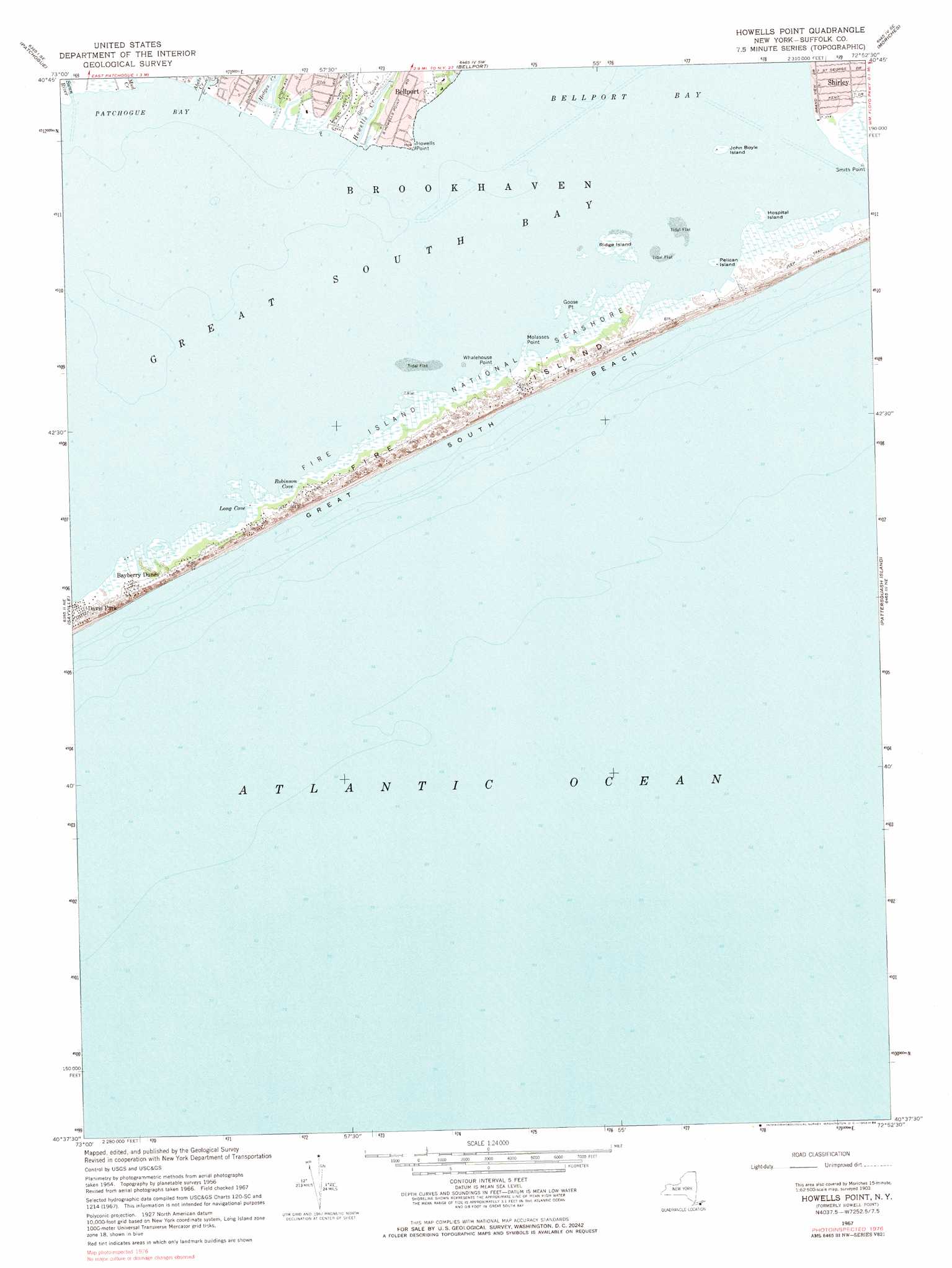
Howells Point Topo Map New York
To zoom in, hover over the map of Howells Point
USGS Topo Quad 40072f8 - 1:24,000 scale
| Topo Map Name: | Howells Point |
| USGS Topo Quad ID: | 40072f8 |
| Print Size: | ca. 21 1/4" wide x 27" high |
| Southeast Coordinates: | 40.625° N latitude / 72.875° W longitude |
| Map Center Coordinates: | 40.6875° N latitude / 72.9375° W longitude |
| U.S. State: | NY |
| Filename: | o40072f8.jpg |
| Download Map JPG Image: | Howells Point topo map 1:24,000 scale |
| Map Type: | Topographic |
| Topo Series: | 7.5´ |
| Map Scale: | 1:24,000 |
| Source of Map Images: | United States Geological Survey (USGS) |
| Alternate Map Versions: |
Howells Point NY 1947 Download PDF Buy paper map Howells Point NY 1956, updated 1957 Download PDF Buy paper map Howells Point NY 1956, updated 1965 Download PDF Buy paper map Howells Point NY 1967, updated 1968 Download PDF Buy paper map Howells Point NY 1967, updated 1984 Download PDF Buy paper map Howells Point NY 1967, updated 1984 Download PDF Buy paper map Howells Point NY 2010 Download PDF Buy paper map Howells Point NY 2013 Download PDF Buy paper map Howells Point NY 2016 Download PDF Buy paper map |
1:24,000 Topo Quads surrounding Howells Point
Saint James |
Port Jefferson |
Middle Island |
Wading River |
Riverhead |
Central Islip |
Patchogue |
Bellport |
Moriches |
Eastport |
Bay Shore East |
Sayville |
Howells Point |
Pattersquash Island |
|
> Back to 40072e1 at 1:100,000 scale
> Back to 40072a1 at 1:250,000 scale
> Back to U.S. Topo Maps home
Howells Point topo map: Gazetteer
Howells Point: Bays
Long Cove elevation 0m 0′Robinson Cove elevation 0m 0′
Howells Point: Capes
Goose Point elevation 0m 0′Howells Point elevation 2m 6′
Molasses Point elevation 0m 0′
Whalehouse Point elevation 0m 0′
Howells Point: Islands
Hospital Island elevation 0m 0′John Boyle Island elevation 0m 0′
Pelican Island elevation 0m 0′
Ridge Island elevation 0m 0′
Howells Point: Populated Places
Bayberry Dunes elevation 2m 6′Howells Point: Streams
Abets Creek elevation 3m 9′Hedges Creek elevation 0m 0′
Howells Creek elevation 0m 0′
Mud Creek elevation 0m 0′
Swan River elevation 0m 0′
Howells Point digital topo map on disk
Buy this Howells Point topo map showing relief, roads, GPS coordinates and other geographical features, as a high-resolution digital map file on DVD:
Atlantic Coast (NY, NJ, PA, DE, MD, VA, NC)
Buy digital topo maps: Atlantic Coast (NY, NJ, PA, DE, MD, VA, NC)
 map DVD")