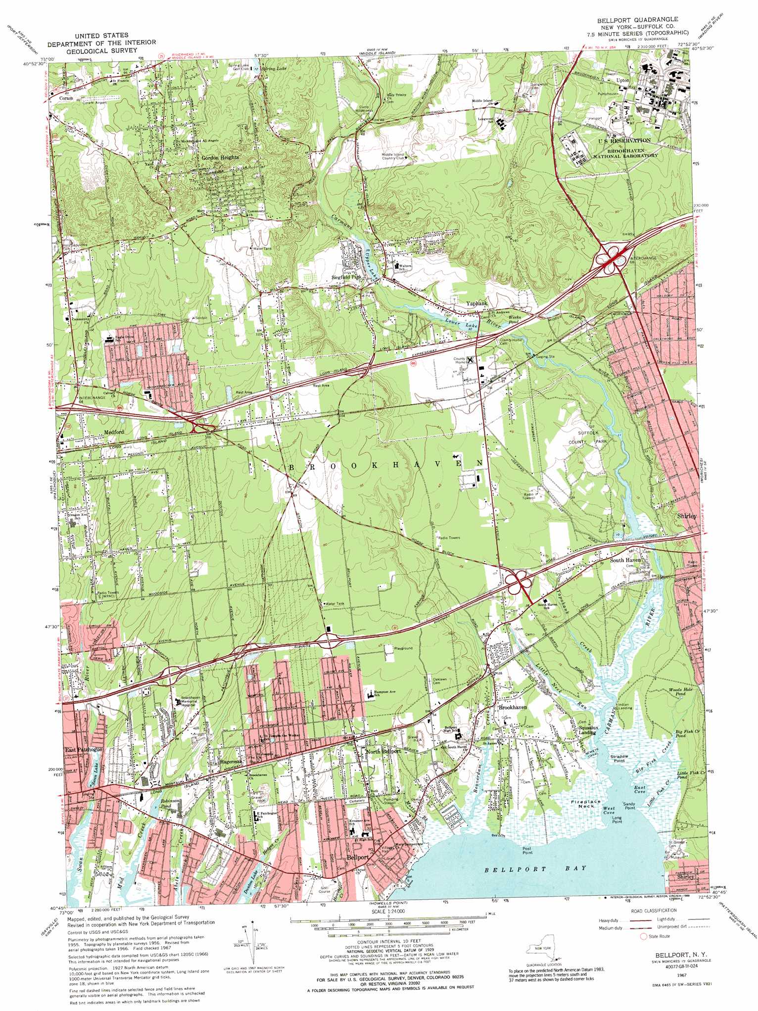
Bellport Topo Map New York
To zoom in, hover over the map of Bellport
USGS Topo Quad 40072g8 - 1:24,000 scale
| Topo Map Name: | Bellport |
| USGS Topo Quad ID: | 40072g8 |
| Print Size: | ca. 21 1/4" wide x 27" high |
| Southeast Coordinates: | 40.75° N latitude / 72.875° W longitude |
| Map Center Coordinates: | 40.8125° N latitude / 72.9375° W longitude |
| U.S. State: | NY |
| Filename: | o40072g8.jpg |
| Download Map JPG Image: | Bellport topo map 1:24,000 scale |
| Map Type: | Topographic |
| Topo Series: | 7.5´ |
| Map Scale: | 1:24,000 |
| Source of Map Images: | United States Geological Survey (USGS) |
| Alternate Map Versions: |
Bellport NY 1947 Download PDF Buy paper map Bellport NY 1956, updated 1958 Download PDF Buy paper map Bellport NY 1967, updated 1969 Download PDF Buy paper map Bellport NY 1967, updated 1970 Download PDF Buy paper map Bellport NY 1967, updated 1989 Download PDF Buy paper map Bellport NY 2010 Download PDF Buy paper map Bellport NY 2013 Download PDF Buy paper map Bellport NY 2016 Download PDF Buy paper map |
1:24,000 Topo Quads surrounding Bellport
Saint James |
Port Jefferson |
Middle Island |
Wading River |
Riverhead |
Central Islip |
Patchogue |
Bellport |
Moriches |
Eastport |
Bay Shore East |
Sayville |
Howells Point |
Pattersquash Island |
|
> Back to 40072e1 at 1:100,000 scale
> Back to 40072a1 at 1:250,000 scale
> Back to U.S. Topo Maps home
Bellport topo map: Gazetteer
Bellport: Airports
Coram Airport elevation 33m 108′Norman Kurrass Contractor Heliport elevation 10m 32′
Bellport: Bays
Bellport Bay elevation 0m 0′East Cove elevation 0m 0′
West Cove elevation 0m 0′
Bellport: Canals
Neweys Canal elevation 1m 3′Bellport: Capes
Fireplace Neck elevation 1m 3′Long Point elevation 0m 0′
Post Point elevation 1m 3′
Sandy Point elevation 1m 3′
Straddle Point elevation 1m 3′
Bellport: Crossings
Interchange 54 elevation 16m 52′Interchange 55 elevation 14m 45′
Interchange 56 elevation 21m 68′
Interchange 57 elevation 9m 29′
Interchange 64 elevation 30m 98′
Interchange 65 elevation 26m 85′
Interchange 66 elevation 31m 101′
Interchange 67 elevation 12m 39′
Interchange 68 elevation 29m 95′
Bellport: Lakes
Big Fish Creek Pond elevation 1m 3′Little Fish Creek Pond elevation 0m 0′
Spring Lake elevation 22m 72′
Swan Lake elevation 2m 6′
Woods Hole Pond elevation 1m 3′
Bellport: Parks
Bellport Village Historic District elevation 8m 26′Cathedral Pines County Park elevation 25m 82′
Granny Road Park elevation 48m 157′
South Haven County Park elevation 12m 39′
Bellport: Populated Places
Bellport elevation 8m 26′Brookhaven elevation 3m 9′
East Patchogue elevation 7m 22′
Gordon Heights elevation 47m 154′
Hagerman elevation 11m 36′
North Bellport elevation 14m 45′
Siegfield Park elevation 15m 49′
South Haven elevation 9m 29′
Upton elevation 27m 88′
Yaphank elevation 12m 39′
Bellport: Post Offices
Bellport Post Office elevation 8m 26′Bellport: Reservoirs
Dunton Lake elevation 1m 3′Lower Lake elevation 9m 29′
Robinson Pond elevation 2m 6′
Upper Lake elevation 12m 39′
Weeks Pond elevation 9m 29′
Bellport: Streams
Beaverdam Creek elevation 0m 0′Big Fish Creek elevation 0m 0′
Carmans River elevation 0m 0′
Little Fish Creek elevation 0m 0′
Little Neck Run elevation 1m 3′
Motts Brook elevation 0m 0′
Yapahank Creek elevation 0m 0′
Bellport digital topo map on disk
Buy this Bellport topo map showing relief, roads, GPS coordinates and other geographical features, as a high-resolution digital map file on DVD:
Atlantic Coast (NY, NJ, PA, DE, MD, VA, NC)
Buy digital topo maps: Atlantic Coast (NY, NJ, PA, DE, MD, VA, NC)
 map DVD")