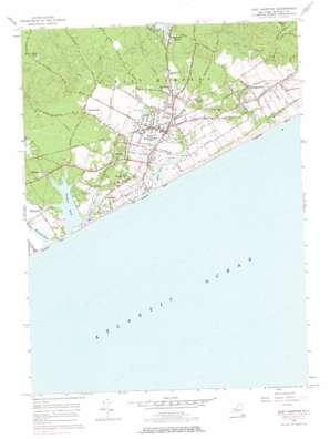
East Hampton Topo Map New York
To zoom in, hover over the map of East Hampton
USGS Topo Quad 40072h2 - 1:24,000 scale
| Topo Map Name: | East Hampton |
| USGS Topo Quad ID: | 40072h2 |
| Print Size: | ca. 21 1/4" wide x 27" high |
| Southeast Coordinates: | 40.875° N latitude / 72.125° W longitude |
| Map Center Coordinates: | 40.9375° N latitude / 72.1875° W longitude |
| U.S. State: | NY |
| Filename: | o40072h2.jpg |
| Download Map JPG Image: | East Hampton topo map 1:24,000 scale |
| Map Type: | Topographic |
| Topo Series: | 7.5´ |
| Map Scale: | 1:24,000 |
| Source of Map Images: | United States Geological Survey (USGS) |
| Alternate Map Versions: |
East Hampton NY 1947, updated 1947 Download PDF Buy paper map East Hampton NY 1956, updated 1958 Download PDF Buy paper map East Hampton NY 1956, updated 1967 Download PDF Buy paper map East Hampton NY 1956, updated 1984 Download PDF Buy paper map East Hampton NY 1956, updated 1984 Download PDF Buy paper map East Hampton NY 2010 Download PDF Buy paper map East Hampton NY 2013 Download PDF Buy paper map East Hampton NY 2016 Download PDF Buy paper map |
1:24,000 Topo Quads surrounding East Hampton
Orient |
Plum Island |
|||
Southold |
Greenport |
Gardiners Island West |
Gardiners Island East |
Montauk Point |
Southampton |
Sag Harbor |
East Hampton |
Napeague Beach |
|
Shinnecock Inlet |
||||
> Back to 40072e1 at 1:100,000 scale
> Back to 40072a1 at 1:250,000 scale
> Back to U.S. Topo Maps home
East Hampton topo map: Gazetteer
East Hampton: Airports
Bistrians Heliport elevation 21m 68′East Hampton: Bays
Georgica Cove elevation 0m 0′East Hampton: Beaches
Amagansett Beach elevation 0m 0′East Hampton Beach elevation 3m 9′
Wainscott Beach elevation 1m 3′
East Hampton: Capes
Georgica Neck elevation 4m 13′East Hampton: Lakes
Georgica Pond elevation 0m 0′Hook Pond elevation 1m 3′
Lily Pond elevation 1m 3′
Town Pond elevation 5m 16′
Two Holes Pond elevation 4m 13′
Wainscott Pond elevation 1m 3′
East Hampton: Parks
Amagansett National Wildlife Refuge elevation 2m 6′Atlantic Double Dunes Preserve elevation 3m 9′
Briar Patch Road Historic District elevation 4m 13′
Buell's Lane Historic District elevation 12m 39′
Egypt Lane Historic District elevation 3m 9′
Fulling Mill Farm Preserve elevation 5m 16′
Jones Road Historic District elevation 3m 9′
North Main Street Historic District elevation 9m 29′
Pantigo Road Historic District elevation 9m 29′
East Hampton: Populated Places
Amagansett elevation 9m 29′Apaquogue elevation 6m 19′
Barnes Hole elevation 7m 22′
Divinity Hill elevation 7m 22′
East Hampton elevation 10m 32′
Freetown elevation 8m 26′
Georgica elevation 8m 26′
Hardscrabble elevation 14m 45′
Jericho elevation 10m 32′
Midhampton elevation 6m 19′
Pantigo elevation 12m 39′
Three Mile Harbor Mobile Home Park elevation 2m 6′
Wainscott elevation 7m 22′
West Amagansett elevation 12m 39′
East Hampton: Post Offices
East Hampton Post Office elevation 4m 13′East Hampton: Streams
Tanbark Creek elevation 1m 3′East Hampton digital topo map on disk
Buy this East Hampton topo map showing relief, roads, GPS coordinates and other geographical features, as a high-resolution digital map file on DVD:
Atlantic Coast (NY, NJ, PA, DE, MD, VA, NC)
Buy digital topo maps: Atlantic Coast (NY, NJ, PA, DE, MD, VA, NC)


