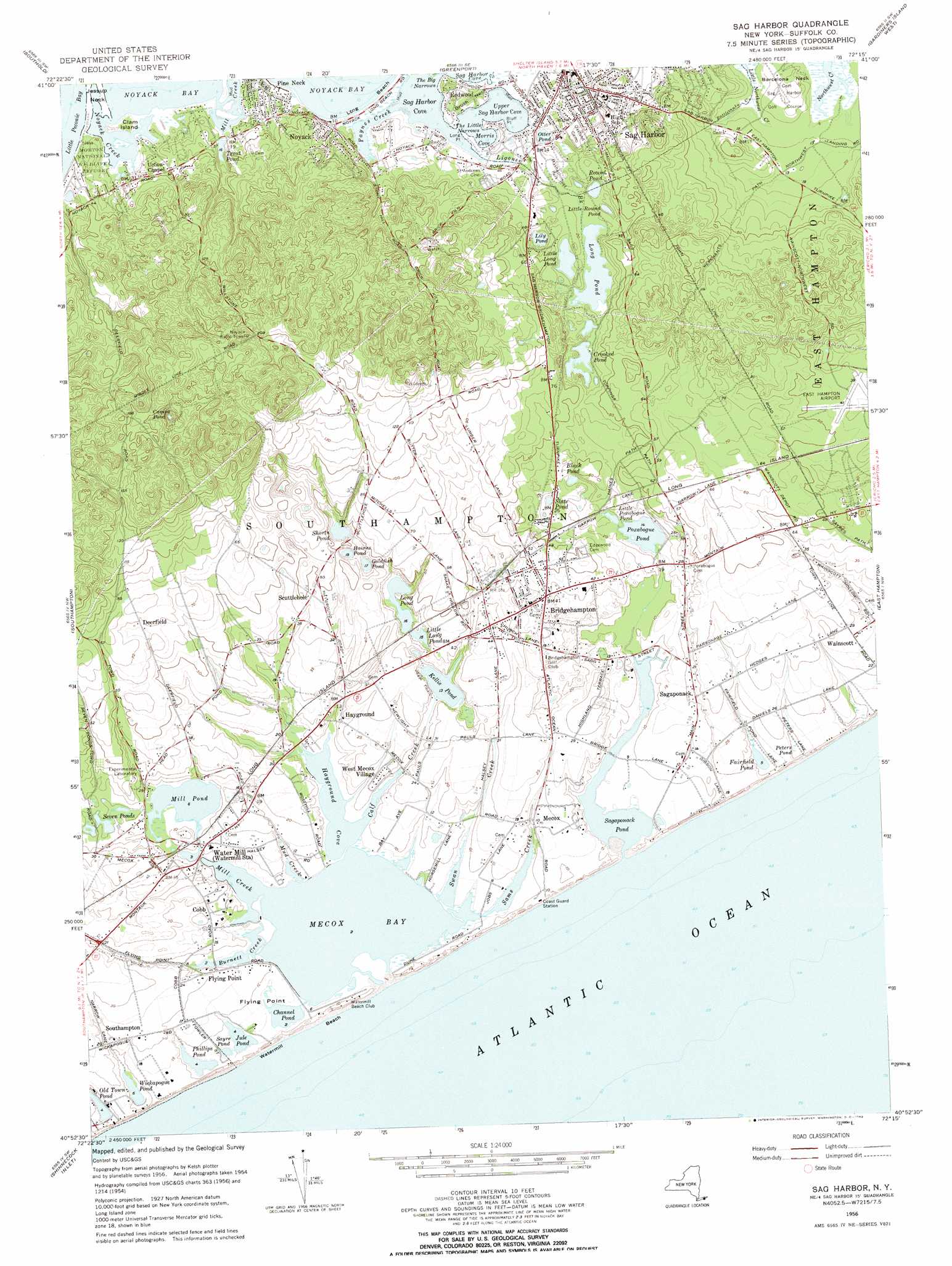
Sag Harbor Topo Map New York
To zoom in, hover over the map of Sag Harbor
USGS Topo Quad 40072h3 - 1:24,000 scale
| Topo Map Name: | Sag Harbor |
| USGS Topo Quad ID: | 40072h3 |
| Print Size: | ca. 21 1/4" wide x 27" high |
| Southeast Coordinates: | 40.875° N latitude / 72.25° W longitude |
| Map Center Coordinates: | 40.9375° N latitude / 72.3125° W longitude |
| U.S. State: | NY |
| Filename: | o40072h3.jpg |
| Download Map JPG Image: | Sag Harbor topo map 1:24,000 scale |
| Map Type: | Topographic |
| Topo Series: | 7.5´ |
| Map Scale: | 1:24,000 |
| Source of Map Images: | United States Geological Survey (USGS) |
| Alternate Map Versions: |
Sag Harbor NY 1946 Download PDF Buy paper map Sag Harbor NY 1956, updated 1958 Download PDF Buy paper map Sag Harbor NY 1956, updated 1969 Download PDF Buy paper map Sag Harbor NY 2010 Download PDF Buy paper map Sag Harbor NY 2013 Download PDF Buy paper map Sag Harbor NY 2016 Download PDF Buy paper map |
1:24,000 Topo Quads surrounding Sag Harbor
Orient |
Plum Island |
|||
Mattituck Hills |
Southold |
Greenport |
Gardiners Island West |
Gardiners Island East |
Mattituck |
Southampton |
Sag Harbor |
East Hampton |
Napeague Beach |
Quogue |
Shinnecock Inlet |
|||
> Back to 40072e1 at 1:100,000 scale
> Back to 40072a1 at 1:250,000 scale
> Back to U.S. Topo Maps home
Sag Harbor topo map: Gazetteer
Sag Harbor: Airports
East Hampton Airport elevation 11m 36′Hampton Airport (historical) elevation 11m 36′
Sag Harbor: Bays
Burnett Creek elevation 0m 0′Hayground Cove elevation 0m 0′
Mecox Bay elevation 0m 0′
Mill Creek elevation 0m 0′
Mill Creek elevation 0m 0′
Morris Cove elevation 0m 0′
Noyack Creek elevation 0m 0′
Paynes Creek elevation 0m 0′
Upper Sag Harbor Cove elevation 0m 0′
Sag Harbor: Beaches
Long Beach elevation 0m 0′Watermill Beach elevation 1m 3′
Sag Harbor: Bridges
Bridgehampton Golf Club elevation 5m 16′Sag Harbor: Capes
Bluff Point elevation 2m 6′Brush Neck elevation 3m 9′
Flying Point elevation 1m 3′
Long Point elevation 0m 0′
Sag Harbor: Channels
The Big Narrows elevation 0m 0′The Little Narrows elevation 0m 0′
Sag Harbor: Guts
Mud Creek elevation 1m 3′Sag Harbor: Islands
Clam Island elevation 2m 6′Sag Harbor: Lakes
Black Pond elevation 3m 9′Camps Pond elevation 31m 101′
Channel Pond elevation 0m 0′
Crooked Pond elevation 4m 13′
Fairfield Pond elevation 1m 3′
Goldfish Pond elevation 5m 16′
Haines Pond elevation 5m 16′
Jule Pond elevation 1m 3′
Kellis Pond elevation 4m 13′
Lily Pond elevation 3m 9′
Little Long Pond elevation 4m 13′
Little Long Pond elevation 4m 13′
Little Poxabogue Pond elevation 6m 19′
Little Round Pond elevation 2m 6′
Long Pond elevation 4m 13′
Long Pond elevation 5m 16′
Mill Pond elevation 2m 6′
Old Town Pond elevation 1m 3′
Otter Pond elevation 1m 3′
Phillips Pond elevation 1m 3′
Poxabogue Pond elevation 4m 13′
Round Pond elevation 2m 6′
Sagaponack Pond elevation 0m 0′
Sayre Pond elevation 1m 3′
Seven Ponds elevation 3m 9′
Shorts Pond elevation 7m 22′
Slate Pond elevation 6m 19′
Wickapogue Pond elevation 1m 3′
Sag Harbor: Parks
Mashashimuet Park elevation 5m 16′Poxabogue County Park elevation 9m 29′
Sagaponack Historic District elevation 7m 22′
Sagg Swamp Nature Preserve elevation 2m 6′
Wickapogue Road Historic District elevation 6m 19′
Sag Harbor: Populated Places
Bridgehampton elevation 13m 42′Cobb elevation 5m 16′
Deerfield elevation 21m 68′
Flying Point elevation 5m 16′
Hayground elevation 4m 13′
Mecox elevation 3m 9′
Noyack elevation 8m 26′
Pine Neck elevation 3m 9′
Redwood elevation 7m 22′
Sag Harbor elevation 8m 26′
Sagaponack elevation 7m 22′
Scuttlehole elevation 11m 36′
Water Mill elevation 10m 32′
Watermill elevation 12m 39′
West Mecox Village elevation 6m 19′
Sag Harbor: Reservoirs
Trout Pond elevation 5m 16′Sag Harbor: Streams
Calf Creek elevation 0m 0′Ligonee Brook elevation 1m 3′
Rattlesnake Creek elevation 1m 3′
Sams Creek elevation 0m 0′
Swan Creek elevation 0m 0′
Sag Harbor: Swamps
Peters Pond elevation 4m 13′Sag Harbor digital topo map on disk
Buy this Sag Harbor topo map showing relief, roads, GPS coordinates and other geographical features, as a high-resolution digital map file on DVD:
Atlantic Coast (NY, NJ, PA, DE, MD, VA, NC)
Buy digital topo maps: Atlantic Coast (NY, NJ, PA, DE, MD, VA, NC)
 map DVD")