Lawrence Topo Map New York
To zoom in, hover over the map of Lawrence
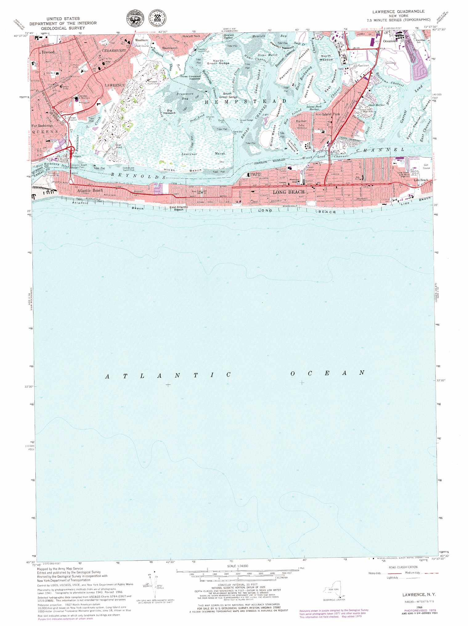
USGS Topo Quad 40073e6 - 1:24,000 scale
| Topo Map Name: | Lawrence |
| USGS Topo Quad ID: | 40073e6 |
| Print Size: | ca. 21 1/4" wide x 27" high |
| Southeast Coordinates: | 40.5° N latitude / 73.625° W longitude |
| Map Center Coordinates: | 40.5625° N latitude / 73.6875° W longitude |
| U.S. State: | NY |
| Filename: | o40073e6.jpg |
| Download Map JPG Image: | Lawrence topo map 1:24,000 scale |
| Map Type: | Topographic |
| Topo Series: | 7.5´ |
| Map Scale: | 1:24,000 |
| Source of Map Images: | United States Geological Survey (USGS) |
| Alternate Map Versions: |
Lawrence NY 1947 Download PDF Buy paper map Lawrence NY 1954, updated 1956 Download PDF Buy paper map Lawrence NY 1966, updated 1968 Download PDF Buy paper map Lawrence NY 1966, updated 1979 Download PDF Buy paper map Lawrence NY 1966, updated 1979 Download PDF Buy paper map Lawrence NY 2012 Download PDF Buy paper map Lawrence NY 2013 Download PDF Buy paper map Lawrence NY 2016 Download PDF Buy paper map |
1:24,000 Topo Quads surrounding Lawrence
Central Park |
Flushing |
Sea Cliff |
Hicksville |
Huntington |
Brooklyn |
Jamaica |
Lynbrook |
Freeport |
Amityville |
Coney Island |
Far Rockaway |
Lawrence |
Jones Inlet |
West Gilgo Beach |
> Back to 40073e1 at 1:100,000 scale
> Back to 40072a1 at 1:250,000 scale
> Back to U.S. Topo Maps home
Lawrence topo map: Gazetteer
Lawrence: Airports
Long Beach Memorial Hospital Heliport elevation 0m 0′Lawrence: Bays
Bannister Bay elevation 0m 0′Brosewere Bay elevation 0m 0′
Island Park Harbor elevation 0m 0′
Shell Harbor elevation 0m 0′
The Lagoon elevation 0m 0′
Lawrence: Beaches
Atlantic Beach elevation 1m 3′East Atlantic Beach elevation 0m 0′
Hicks Beach elevation 0m 0′
Long Beach elevation 0m 0′
Lawrence: Bridges
Atlantic Beach Bridge elevation 6m 19′Lawrence: Canals
Bob Jones Canal elevation 0m 0′California Canal elevation 0m 0′
Hagen Canal elevation 0m 0′
Island Park Channel elevation 0m 0′
Ouimet Canal elevation 0m 0′
Sarazen Canal elevation 0m 0′
Lawrence: Capes
Charles Point elevation 0m 0′Duck Point elevation 0m 0′
Green Sedge Point elevation 0m 0′
Sand Bar Point elevation 0m 0′
Lawrence: Channels
Barnums Channel elevation 0m 0′Broad Channel elevation 0m 0′
Cedar Island Creek elevation 0m 0′
East Channel elevation 0m 0′
East Rockaway Channel elevation 2m 6′
Garrett Lead elevation 0m 0′
Hog Island Channel elevation 0m 0′
Neds Hole Creek elevation 0m 0′
Nums Channel elevation 0m 0′
Post Lead elevation 0m 0′
Ramscat Channel elevation 0m 0′
Reynolds Channel elevation 0m 0′
Swift Creek elevation 0m 0′
Woodmere Channel elevation 0m 0′
Woodsburgh Channel elevation 0m 0′
Wreck Lead Channel elevation 0m 0′
Lawrence: Flats
East Meadow elevation 0m 0′North Meadow elevation 0m 0′
West Meadow elevation 2m 6′
Lawrence: Guts
Crooked Creek elevation 0m 0′Lawrence: Islands
Big Hassock elevation 1m 3′Cedar Island elevation 0m 0′
Cedar Island Marsh elevation 0m 0′
East Channel Islands elevation 0m 0′
Hawlett Hassock elevation 0m 0′
Jeckyl Island elevation 0m 0′
North Black Banks Hassock elevation 1m 3′
Pearsalls Hassock elevation 1m 3′
Post Marsh elevation 0m 0′
Simmons Hassock elevation 0m 0′
South Black Banks Hassock elevation 1m 3′
Three Cornered Hassock elevation 0m 0′
Lawrence: Lakes
Sage Pond elevation 2m 6′Lawrence: Parks
Beach 9th Street Playground elevation 1m 3′Lanett Playground elevation 3m 9′
Lawrence Nature Preserve elevation 1m 3′
Lido West Town Park elevation 0m 0′
O'Donohue Park elevation 1m 3′
Seagirt Avenue Wetlands elevation 1m 3′
Shell Creek Park elevation 0m 0′
Silver Point County Park elevation 1m 3′
Lawrence: Populated Places
Atlantic Beach elevation 5m 16′Atlantic Beach Estates elevation 2m 6′
Barnum Island elevation 0m 0′
Cedarhurst elevation 8m 26′
Harbor Isle elevation 0m 0′
Hewlett Neck elevation 2m 6′
Inwood elevation 3m 9′
Island Park elevation 0m 0′
Lawrence elevation 6m 19′
Lido Beach elevation 0m 0′
Long Beach elevation 0m 0′
North Lynbrook elevation 0m 0′
Ocean Point elevation 8m 26′
Roy Reuther Houses elevation 1m 3′
Woodsburgh elevation 2m 6′
Lawrence: Post Offices
Atlantic Beach Post Office elevation 4m 13′Cedarhurst Post Office elevation 8m 26′
Island Park Post Office elevation 0m 0′
Long Beach Post Office elevation 0m 0′
Lawrence: Streams
Bannister Creek elevation 1m 3′Bridge Creek elevation 0m 0′
Shell Creek elevation 0m 0′
Lawrence: Swamps
Garrett Marsh elevation 0m 0′Lawrence Marsh elevation 0m 0′
North Green Sedge elevation 0m 0′
Nums Marsh elevation 0m 0′
South Green Sedge elevation 0m 0′
Lawrence digital topo map on disk
Buy this Lawrence topo map showing relief, roads, GPS coordinates and other geographical features, as a high-resolution digital map file on DVD:
Atlantic Coast (NY, NJ, PA, DE, MD, VA, NC)
Buy digital topo maps: Atlantic Coast (NY, NJ, PA, DE, MD, VA, NC)
 map DVD")