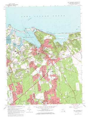
Port Jefferson Topo Map New York
To zoom in, hover over the map of Port Jefferson
USGS Topo Quad 40073h1 - 1:24,000 scale
| Topo Map Name: | Port Jefferson |
| USGS Topo Quad ID: | 40073h1 |
| Print Size: | ca. 21 1/4" wide x 27" high |
| Southeast Coordinates: | 40.875° N latitude / 73° W longitude |
| Map Center Coordinates: | 40.9375° N latitude / 73.0625° W longitude |
| U.S. State: | NY |
| Filename: | o40073h1.jpg |
| Download Map JPG Image: | Port Jefferson topo map 1:24,000 scale |
| Map Type: | Topographic |
| Topo Series: | 7.5´ |
| Map Scale: | 1:24,000 |
| Source of Map Images: | United States Geological Survey (USGS) |
| Alternate Map Versions: |
Port Jefferson NY 1947 Download PDF Buy paper map Port Jefferson NY 1955, updated 1957 Download PDF Buy paper map Port Jefferson NY 1955, updated 1966 Download PDF Buy paper map Port Jefferson NY 1967, updated 1969 Download PDF Buy paper map Port Jefferson NY 2010 Download PDF Buy paper map Port Jefferson NY 2013 Download PDF Buy paper map Port Jefferson NY 2016 Download PDF Buy paper map |
1:24,000 Topo Quads surrounding Port Jefferson
> Back to 40073e1 at 1:100,000 scale
> Back to 40072a1 at 1:250,000 scale
> Back to U.S. Topo Maps home
Port Jefferson topo map: Gazetteer
Port Jefferson: Airports
Health Sciences Center University Hospital Heliport elevation 65m 213′Mather Heliport elevation 58m 190′
Saint Charles Hospital Heliport elevation 66m 216′
Port Jefferson: Areas
Nonowatuck (historical) elevation 44m 144′Port Jefferson: Bars
Hatch Rock elevation 0m 0′Low Tide Rock elevation 0m 0′
Millers Rock elevation 0m 0′
Moneyhollow Rock elevation 0m 0′
Mount Misery Shoal elevation 0m 0′
Port Jefferson: Bays
Conscience Bay elevation 0m 0′Little Bay elevation 0m 0′
Mount Sinai Harbor elevation 0m 0′
Port Jefferson Harbor elevation 0m 0′
Setauket Harbor elevation 0m 0′
Port Jefferson: Beaches
Cedar Beach elevation 0m 0′Miller Place Beach elevation 0m 0′
Old Field Beach elevation 0m 0′
White Beach elevation 0m 0′
Port Jefferson: Capes
Mount Misery Point elevation 0m 0′Old Field Point elevation 12m 39′
Strongs Neck elevation 12m 39′
Port Jefferson: Channels
The Narrows elevation 0m 0′Port Jefferson: Crossings
Bridgeport Ferry elevation 0m 0′Port Jefferson: Parks
McAllister County Park elevation 4m 13′Port Jefferson Village Historic District elevation 13m 42′
Port Jefferson: Populated Places
Belle Terre elevation 49m 160′Crystal Brook elevation 13m 42′
East Setauket elevation 20m 65′
Mount Sinai elevation 10m 32′
Poquott elevation 20m 65′
Port Jefferson elevation 1m 3′
Port Jefferson Station elevation 54m 177′
Setauket elevation 8m 26′
South Setauket elevation 40m 131′
Terryville elevation 46m 150′
Port Jefferson: Post Offices
Port Jefferson Post Office elevation 6m 19′Port Jefferson: Reservoirs
Setauket Millpond elevation 3m 9′Port Jefferson: Summits
Mount Misery elevation 54m 177′Port Jefferson: Valleys
Crystal Brook Hollow elevation 0m 0′Pipe Stave Hollow elevation 2m 6′
Port Jefferson digital topo map on disk
Buy this Port Jefferson topo map showing relief, roads, GPS coordinates and other geographical features, as a high-resolution digital map file on DVD:
Atlantic Coast (NY, NJ, PA, DE, MD, VA, NC)
Buy digital topo maps: Atlantic Coast (NY, NJ, PA, DE, MD, VA, NC)


