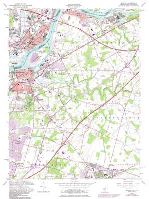
Bristol Topo Map New Jersey
To zoom in, hover over the map of Bristol
USGS Topo Quad 40074a7 - 1:24,000 scale
| Topo Map Name: | Bristol |
| USGS Topo Quad ID: | 40074a7 |
| Print Size: | ca. 21 1/4" wide x 27" high |
| Southeast Coordinates: | 40° N latitude / 74.75° W longitude |
| Map Center Coordinates: | 40.0625° N latitude / 74.8125° W longitude |
| U.S. States: | NJ, PA |
| Filename: | o40074a7.jpg |
| Download Map JPG Image: | Bristol topo map 1:24,000 scale |
| Map Type: | Topographic |
| Topo Series: | 7.5´ |
| Map Scale: | 1:24,000 |
| Source of Map Images: | United States Geological Survey (USGS) |
| Alternate Map Versions: |
Bristol PA 1947 Download PDF Buy paper map Bristol PA 1955, updated 1957 Download PDF Buy paper map Bristol PA 1955, updated 1972 Download PDF Buy paper map Bristol PA 1955, updated 1982 Download PDF Buy paper map Bristol PA 1955, updated 1982 Download PDF Buy paper map Bristol PA 2011 Download PDF Buy paper map Bristol PA 2013 Download PDF Buy paper map Bristol PA 2016 Download PDF Buy paper map |
1:24,000 Topo Quads surrounding Bristol
> Back to 40074a1 at 1:100,000 scale
> Back to 40074a1 at 1:250,000 scale
> Back to U.S. Topo Maps home
Bristol topo map: Gazetteer
Bristol: Airports
Blue Jay Heliport elevation 17m 55′Burlington Generating Station Heliport elevation 6m 19′
Colgate Palmolive Heliport elevation 14m 45′
Copter-PNB-Bristol Heliport elevation 7m 22′
Indel Airpark elevation 19m 62′
Inductotherm Airport elevation 20m 65′
Bristol: Bars
Kinkora Bar elevation 2m 6′Bristol: Bridges
Burlington Bristol Bridge elevation 1m 3′Delaware River Bridge elevation 2m 6′
Suttons Bridge elevation 4m 13′
Bristol: Channels
Bristol Range elevation 1m 3′Canal Channel elevation 1m 3′
Canal Channel elevation 1m 3′
Devlin Channel elevation 1m 3′
Devlin Channel elevation 1m 3′
Florence Range elevation 2m 6′
Florence Range elevation 2m 6′
Keystone Range elevation 1m 3′
Keystone Range elevation 1m 3′
Landreth Channel elevation 2m 6′
Landreth Channel elevation 2m 6′
Lehigh Channel elevation 1m 3′
Lehigh Channel elevation 1m 3′
Roebling Range elevation 2m 6′
Roebling Range elevation 2m 6′
Bristol: Crossings
Interchange 358 elevation 11m 36′Interchange 359 elevation 13m 42′
Pennsylvania Turnpike Interchange 29 elevation 13m 42′
Pennsylvania Turnpike Interchange 30 elevation 5m 16′
Bristol: Dams
Silver Lake Dam elevation 7m 22′Sylvan Lake Dam elevation 5m 16′
Bristol: Islands
Burlington Island elevation 6m 19′Bristol: Lakes
John F Kennedy Lake elevation 6m 19′Magnolia Lake elevation 5m 16′
Silver Lake elevation 5m 16′
Bristol: Parks
John F Kennedy Park elevation 7m 22′Silver Lake County Park elevation 6m 19′
Bristol: Populated Places
Bath Addition elevation 6m 19′Bristol elevation 6m 19′
Bristol Terrace Number One elevation 8m 26′
Bristol Terrace Number Two elevation 9m 29′
Burlington elevation 7m 22′
Bustleton elevation 20m 65′
Deacons elevation 26m 85′
East Burlington elevation 4m 13′
Farnerville elevation 7m 22′
Florence elevation 8m 26′
Florence Station elevation 14m 45′
Garfield Park East elevation 12m 39′
Garfield Park North elevation 9m 29′
Hawthorne Park elevation 11m 36′
Jacksonville elevation 19m 62′
Kinkora elevation 12m 39′
Maple Beach elevation 6m 19′
Margo Gardens elevation 6m 19′
Orchard View elevation 6m 19′
Rancocas elevation 18m 59′
Roebling elevation 14m 45′
Springside elevation 21m 68′
Stevens elevation 11m 36′
Timbuctoo elevation 12m 39′
Town Estates elevation 13m 42′
Unionville elevation 11m 36′
Willingboro elevation 11m 36′
Winder Village elevation 6m 19′
Woodlane elevation 18m 59′
Bristol: Post Offices
Bristol Post Office (historical) elevation 6m 19′Bristol: Reservoirs
Silver Lake elevation 7m 22′Sylvan Lake elevation 5m 16′
Bristol: Streams
Assiscunk Creek elevation 2m 6′Barkers Brook elevation 11m 36′
Bustleton Creek elevation 2m 6′
Crafts Creek elevation 1m 3′
Mill Creek elevation -6m -20′
Otter Creek elevation 2m 6′
Bristol: Summits
Laurel Hill elevation 6m 19′Mount Holly elevation 42m 137′
Bristol: Woods
Fountain Woods elevation 6m 19′Bristol digital topo map on disk
Buy this Bristol topo map showing relief, roads, GPS coordinates and other geographical features, as a high-resolution digital map file on DVD:
Atlantic Coast (NY, NJ, PA, DE, MD, VA, NC)
Buy digital topo maps: Atlantic Coast (NY, NJ, PA, DE, MD, VA, NC)


