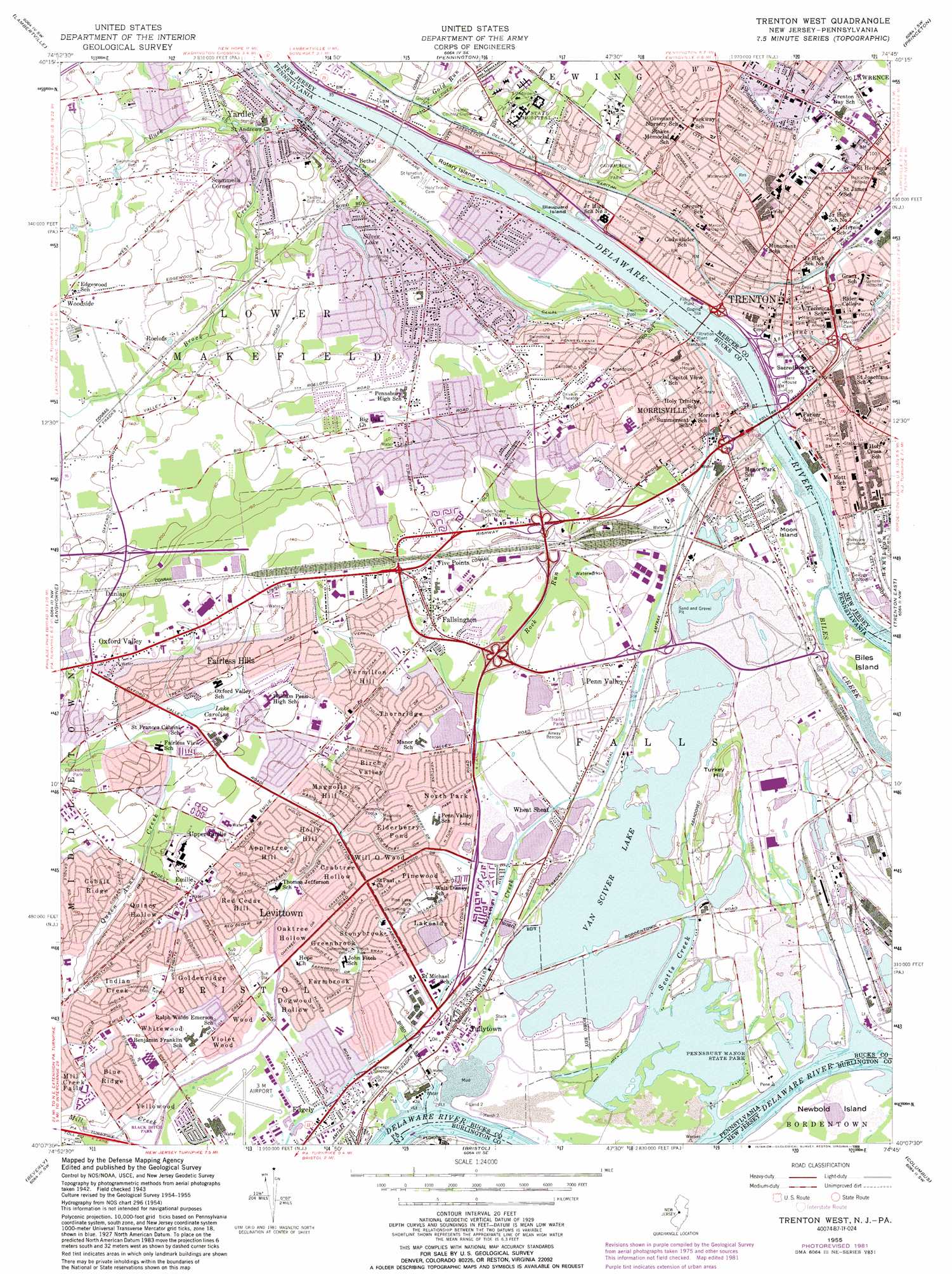
Trenton West Topo Map Pennsylvania
To zoom in, hover over the map of Trenton West
USGS Topo Quad 40074b7 - 1:24,000 scale
| Topo Map Name: | Trenton West |
| USGS Topo Quad ID: | 40074b7 |
| Print Size: | ca. 21 1/4" wide x 27" high |
| Southeast Coordinates: | 40.125° N latitude / 74.75° W longitude |
| Map Center Coordinates: | 40.1875° N latitude / 74.8125° W longitude |
| U.S. States: | PA, NJ |
| Filename: | o40074b7.jpg |
| Download Map JPG Image: | Trenton West topo map 1:24,000 scale |
| Map Type: | Topographic |
| Topo Series: | 7.5´ |
| Map Scale: | 1:24,000 |
| Source of Map Images: | United States Geological Survey (USGS) |
| Alternate Map Versions: |
Trenton West NJ 1947 Download PDF Buy paper map Trenton West NJ 1955, updated 1957 Download PDF Buy paper map Trenton West NJ 1955, updated 1963 Download PDF Buy paper map Trenton West NJ 1955, updated 1972 Download PDF Buy paper map Trenton West NJ 1955, updated 1982 Download PDF Buy paper map Trenton West NJ 1955, updated 1989 Download PDF Buy paper map Trenton West NJ 1995, updated 1998 Download PDF Buy paper map Trenton West NJ 2011 Download PDF Buy paper map Trenton West NJ 2014 Download PDF Buy paper map Trenton West NJ 2016 Download PDF Buy paper map |
1:24,000 Topo Quads surrounding Trenton West
Lumberville |
Stockton |
Hopewell |
Rocky Hill |
Monmouth Junction |
Buckingham |
Lambertville |
Pennington |
Princeton |
Hightstown |
Hatboro |
Langhorne |
Trenton West |
Trenton East |
Allentown |
Frankford |
Beverly |
Bristol |
Columbus |
New Egypt |
Camden |
Moorestown |
Mount Holly |
Pemberton |
Browns Mills |
> Back to 40074a1 at 1:100,000 scale
> Back to 40074a1 at 1:250,000 scale
> Back to U.S. Topo Maps home
Trenton West topo map: Gazetteer
Trenton West: Airports
3-M Heliport elevation 8m 26′McClister Airport elevation 40m 131′
Mercer Medical Center elevation 28m 91′
Trenton Heliport elevation 7m 22′
Trenton West: Channels
Cochran Channel elevation 2m 6′Cochran Channel elevation 2m 6′
Florence Bend elevation 2m 6′
Florence Bend elevation 2m 6′
Kinkora Range elevation 2m 6′
Kinkora Range elevation 2m 6′
Moon Channel elevation 3m 9′
Moon Channel elevation 3m 9′
Newbold Channel elevation 2m 6′
Newbold Channel elevation 2m 6′
Penn Channel elevation 2m 6′
Penn Channel elevation 2m 6′
Trenton Channel elevation 3m 9′
Trenton Channel elevation 3m 9′
Trenton West: Dams
Lake Afton Dam elevation 11m 36′Lake Caroline Dam elevation 21m 68′
Manor Lake Dam elevation 1m 3′
Oxford Valley Mall Dam elevation 46m 150′
Rowan Dam elevation 35m 114′
Rowan Dam elevation 35m 114′
Silver Lake Dam elevation 24m 78′
Silver Lake Dam elevation 24m 78′
Van Sciver Lake Dam elevation 4m 13′
Trenton West: Forests
Five Mile Woods Forest Preserve elevation 54m 177′Trenton West: Islands
Blauguard Island elevation 6m 19′Money Island elevation 4m 13′
Moon Island elevation 6m 19′
Newbold Island elevation 0m 0′
Rotary Island elevation 6m 19′
Trenton West: Lakes
Caroline Lake elevation 21m 68′Curtis Lake elevation 10m 32′
Trenton West: Parks
Brook Park elevation 8m 26′Cadwalader Park elevation 25m 82′
Chickenfoot Park elevation 26m 85′
Fallsington County Park elevation 18m 59′
Levittown Public Recreation Association Park elevation 13m 42′
Magnolia Park elevation 11m 36′
Middletown Township Park elevation 18m 59′
North Trenton Park elevation 28m 91′
Oxford Valley Park elevation 22m 72′
Pennsbury Manor State Park elevation 1m 3′
Pine Lake Park elevation 7m 22′
Sesame Place Amusement Park elevation 49m 160′
Stacy Park elevation 7m 22′
Trenton West: Populated Places
Appletree Hill elevation 26m 85′Birch Valley elevation 12m 39′
Blue Ridge elevation 13m 42′
Cobalt Ridge elevation 24m 78′
Crabtree Hollow elevation 9m 29′
Dogwood Hollow elevation 10m 32′
Dunlap elevation 55m 180′
Edge Hill elevation 54m 177′
Edgely elevation 7m 22′
Elderberry Pond elevation 9m 29′
Emilie elevation 31m 101′
Fairless Hills elevation 33m 108′
Fallsington elevation 25m 82′
Farmbrook elevation 8m 26′
Five Points elevation 28m 91′
Glendale elevation 29m 95′
Goldenridge elevation 20m 65′
Greenbrook elevation 8m 26′
Hillcrest elevation 30m 98′
Holly Hill elevation 25m 82′
Indian Creek elevation 22m 72′
Lakeside elevation 12m 39′
Levittown elevation 9m 29′
Magnolia Hill elevation 17m 55′
Mill Creek Falls elevation 17m 55′
Morrisville elevation 30m 98′
North Park elevation 9m 29′
Oaktree Hollow elevation 10m 32′
Oxford Valley elevation 42m 137′
Penn Valley elevation 12m 39′
Pinewood elevation 9m 29′
Prospect Heights elevation 24m 78′
Prospect Park elevation 28m 91′
Quincy Hollow elevation 26m 85′
Red Cedar Hill elevation 19m 62′
Roelofs elevation 43m 141′
Scammells Corner elevation 52m 170′
Stonybrook elevation 8m 26′
Thornridge elevation 12m 39′
Tullytown elevation 4m 13′
Upper Emilie elevation 32m 104′
Vermilion Hill elevation 22m 72′
Violet Wood elevation 12m 39′
Weber Park elevation 30m 98′
Wheat Sheaf elevation 12m 39′
Whitewood elevation 19m 62′
Will O Wood elevation 10m 32′
Wood elevation 12m 39′
Yardley elevation 22m 72′
Yellowood elevation 10m 32′
Trenton West: Post Offices
Emilie Post Office (historical) elevation 31m 101′Fallsington Post Office (historical) elevation 17m 55′
Yardley Post Office (historical) elevation 22m 72′
Trenton West: Reservoirs
Little Silver Lake elevation 23m 75′Manor Lake elevation 1m 3′
Silver Lake elevation 24m 78′
Van Sciver Lake elevation 3m 9′
Trenton West: Streams
Assunpink Creek elevation 5m 16′Brock Creek elevation 12m 39′
Buck Creek elevation 6m 19′
Gold Run elevation 5m 16′
Martins Creek elevation 2m 6′
Mill Creek elevation 6m 19′
Queen Anne Creek elevation 17m 55′
Rock Run elevation 10m 32′
Scotts Creek elevation 0m 0′
Trenton West: Summits
Turkey Hill elevation 9m 29′Trenton West digital topo map on disk
Buy this Trenton West topo map showing relief, roads, GPS coordinates and other geographical features, as a high-resolution digital map file on DVD:
Atlantic Coast (NY, NJ, PA, DE, MD, VA, NC)
Buy digital topo maps: Atlantic Coast (NY, NJ, PA, DE, MD, VA, NC)
 map DVD")