Freehold Topo Map New Jersey
To zoom in, hover over the map of Freehold
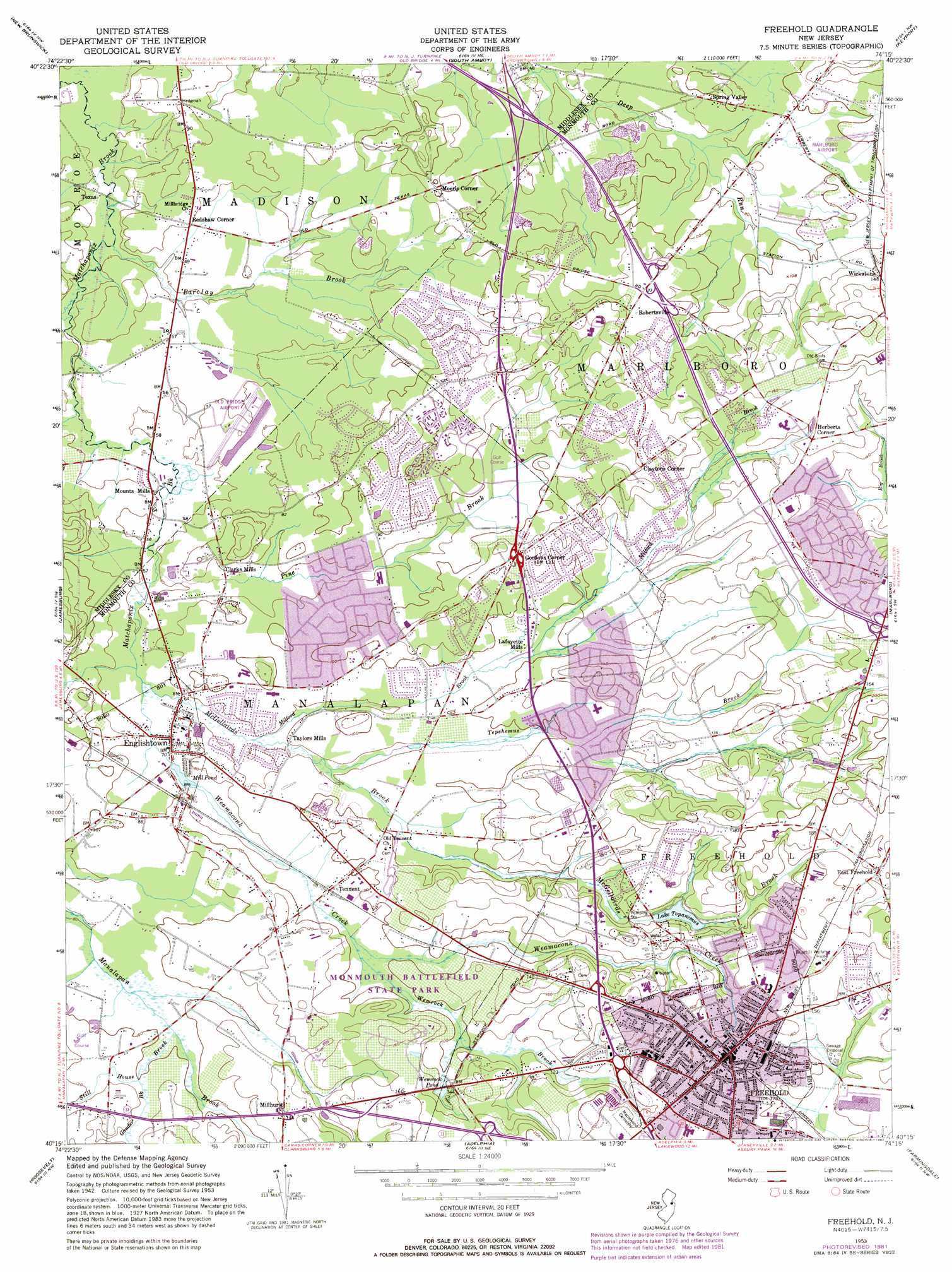
USGS Topo Quad 40074c3 - 1:24,000 scale
| Topo Map Name: | Freehold |
| USGS Topo Quad ID: | 40074c3 |
| Print Size: | ca. 21 1/4" wide x 27" high |
| Southeast Coordinates: | 40.25° N latitude / 74.25° W longitude |
| Map Center Coordinates: | 40.3125° N latitude / 74.3125° W longitude |
| U.S. State: | NJ |
| Filename: | o40074c3.jpg |
| Download Map JPG Image: | Freehold topo map 1:24,000 scale |
| Map Type: | Topographic |
| Topo Series: | 7.5´ |
| Map Scale: | 1:24,000 |
| Source of Map Images: | United States Geological Survey (USGS) |
| Alternate Map Versions: |
Freehold NJ 1947 Download PDF Buy paper map Freehold NJ 1953, updated 1955 Download PDF Buy paper map Freehold NJ 1953, updated 1967 Download PDF Buy paper map Freehold NJ 1953, updated 1972 Download PDF Buy paper map Freehold NJ 1953, updated 1982 Download PDF Buy paper map Freehold NJ 1953, updated 1982 Download PDF Buy paper map Freehold NJ 2011 Download PDF Buy paper map Freehold NJ 2014 Download PDF Buy paper map Freehold NJ 2016 Download PDF Buy paper map |
1:24,000 Topo Quads surrounding Freehold
Bound Brook |
Plainfield |
Perth Amboy |
Arthur Kill |
The Narrows |
Monmouth Junction |
New Brunswick |
South Amboy |
Keyport |
Sandy Hook |
Hightstown |
Jamesburg |
Freehold |
Marlboro |
Long Branch |
Allentown |
Roosevelt |
Adelphia |
Farmingdale |
Asbury Park |
New Egypt |
Cassville |
Lakehurst |
Lakewood |
Point Pleasant |
> Back to 40074a1 at 1:100,000 scale
> Back to 40074a1 at 1:250,000 scale
> Back to U.S. Topo Maps home
Freehold topo map: Gazetteer
Freehold: Airports
Manalapan Township-Village Green Heliport elevation 30m 98′Marlboro Airport (historical) elevation 30m 98′
Old Bridge Airport elevation 23m 75′
Old Bridge Seaplane Base elevation 19m 62′
Werner Airport elevation 17m 55′
Freehold: Crossings
Interchange 25 elevation 50m 164′Interchange 29 elevation 40m 131′
Interchange 30 elevation 19m 62′
Freehold: Dams
Englishtown Lake Dam elevation 23m 75′Lake Topanemus Dam elevation 34m 111′
Wemrock Pond Dam elevation 32m 104′
Freehold: Parks
East Freehold County Park elevation 44m 144′Forman Park elevation 52m 170′
Holiday Park elevation 29m 95′
Monmouth Battle Monument elevation 53m 173′
Monmouth Battlefield State Park elevation 30m 98′
Freehold: Populated Places
Clarks Mills elevation 26m 85′Claytons Corner elevation 45m 147′
East Freehold elevation 53m 173′
Englishtown elevation 21m 68′
Freehold elevation 51m 167′
Gordons Corner elevation 42m 137′
Herberts Corner elevation 50m 164′
Lafayette Mills elevation 28m 91′
Millhurst elevation 43m 141′
Moerls Corner elevation 28m 91′
Monmouth Heights at Manalapan elevation 36m 118′
Mounts Mills elevation 18m 59′
Redshaw Corner elevation 18m 59′
Robertsville elevation 41m 134′
Spring Valley elevation 29m 95′
Taylors Mills elevation 24m 78′
Tennent elevation 27m 88′
Texas elevation 11m 36′
Whittier Oaks elevation 36m 118′
Yorketown elevation 29m 95′
Freehold: Post Offices
Freehold Post Office elevation 50m 164′Freehold: Reservoirs
Lake Topanemus elevation 34m 111′Lake Weamaconk elevation 23m 75′
Wemrock Pond elevation 32m 104′
Freehold: Streams
Barclay Brook elevation 11m 36′Gander Brook elevation 33m 108′
McGellairds Brook elevation 21m 68′
Milford Brook elevation 24m 78′
Pine Brook elevation 18m 59′
Sandy Brook elevation 22m 72′
Still House Brook elevation 28m 91′
Tepehemus Brook elevation 23m 75′
Weamaconk Creek elevation 21m 68′
Wemrock Brook elevation 27m 88′
Freehold digital topo map on disk
Buy this Freehold topo map showing relief, roads, GPS coordinates and other geographical features, as a high-resolution digital map file on DVD:
Atlantic Coast (NY, NJ, PA, DE, MD, VA, NC)
Buy digital topo maps: Atlantic Coast (NY, NJ, PA, DE, MD, VA, NC)
 map DVD")