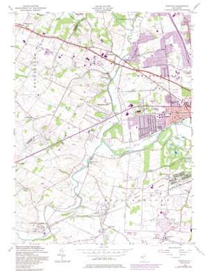
Raritan Topo Map New Jersey
To zoom in, hover over the map of Raritan
USGS Topo Quad 40074e6 - 1:24,000 scale
| Topo Map Name: | Raritan |
| USGS Topo Quad ID: | 40074e6 |
| Print Size: | ca. 21 1/4" wide x 27" high |
| Southeast Coordinates: | 40.5° N latitude / 74.625° W longitude |
| Map Center Coordinates: | 40.5625° N latitude / 74.6875° W longitude |
| U.S. State: | NJ |
| Filename: | o40074e6.jpg |
| Download Map JPG Image: | Raritan topo map 1:24,000 scale |
| Map Type: | Topographic |
| Topo Series: | 7.5´ |
| Map Scale: | 1:24,000 |
| Source of Map Images: | United States Geological Survey (USGS) |
| Alternate Map Versions: |
Raritan NJ 1955, updated 1956 Download PDF Buy paper map Raritan NJ 1955, updated 1965 Download PDF Buy paper map Raritan NJ 1955, updated 1972 Download PDF Buy paper map Raritan NJ 1955, updated 1980 Download PDF Buy paper map Raritan NJ 1955, updated 1982 Download PDF Buy paper map Raritan NJ 1955, updated 1986 Download PDF Buy paper map Raritan NJ 1955, updated 1986 Download PDF Buy paper map Raritan NJ 2011 Download PDF Buy paper map Raritan NJ 2014 Download PDF Buy paper map Raritan NJ 2016 Download PDF Buy paper map |
1:24,000 Topo Quads surrounding Raritan
> Back to 40074e1 at 1:100,000 scale
> Back to 40074a1 at 1:250,000 scale
> Back to U.S. Topo Maps home
Raritan topo map: Gazetteer
Raritan: Airports
City Federal elevation 32m 104′Peters Airport elevation 45m 147′
RCA Sommerville Heliport elevation 42m 137′
Solberg-Hunterdon Airport elevation 52m 170′
Raritan: Canals
Raritan Water Power Canal elevation 16m 52′Raritan: Crossings
Lanes Crossing (historical) elevation 33m 108′Raritan: Parks
Duke Island Park elevation 13m 42′John Basilone Memorial Field elevation 31m 101′
North Branch Park elevation 24m 78′
Raritan: Populated Places
Bradley Gardens elevation 24m 78′Branchburg Park elevation 62m 203′
Flagtown elevation 37m 121′
Frankfort elevation 37m 121′
Milltown elevation 31m 101′
Neshanic Station elevation 28m 91′
North Branch elevation 24m 78′
North Branch Depot elevation 18m 59′
Raritan elevation 21m 68′
Readington elevation 33m 108′
South Branch elevation 22m 72′
Whitehouse elevation 64m 209′
Woods Tavern elevation 30m 98′
Raritan: Streams
Chambers Brook elevation 18m 59′Holland Brook elevation 14m 45′
Neshanic River elevation 21m 68′
North Branch Raritan River elevation 13m 42′
Pleasant Run elevation 17m 55′
River Brook elevation 21m 68′
South Branch Raritan River elevation 13m 42′
Raritan: Valleys
Royce Valley elevation 30m 98′Raritan digital topo map on disk
Buy this Raritan topo map showing relief, roads, GPS coordinates and other geographical features, as a high-resolution digital map file on DVD:
Atlantic Coast (NY, NJ, PA, DE, MD, VA, NC)
Buy digital topo maps: Atlantic Coast (NY, NJ, PA, DE, MD, VA, NC)


