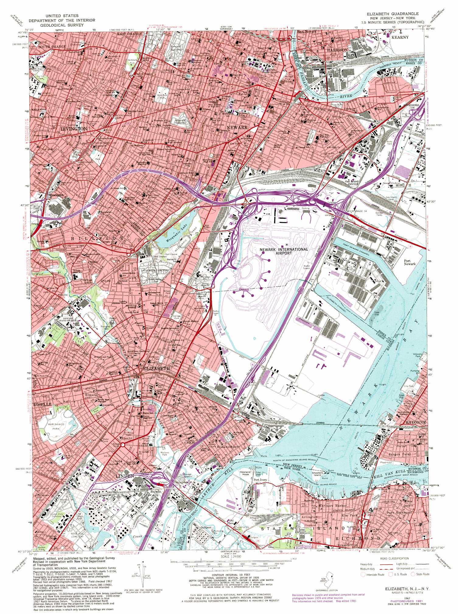
Elizabeth Topo Map New Jersey
To zoom in, hover over the map of Elizabeth
USGS Topo Quad 40074f2 - 1:24,000 scale
| Topo Map Name: | Elizabeth |
| USGS Topo Quad ID: | 40074f2 |
| Print Size: | ca. 21 1/4" wide x 27" high |
| Southeast Coordinates: | 40.625° N latitude / 74.125° W longitude |
| Map Center Coordinates: | 40.6875° N latitude / 74.1875° W longitude |
| U.S. States: | NJ, NY |
| Filename: | o40074f2.jpg |
| Download Map JPG Image: | Elizabeth topo map 1:24,000 scale |
| Map Type: | Topographic |
| Topo Series: | 7.5´ |
| Map Scale: | 1:24,000 |
| Source of Map Images: | United States Geological Survey (USGS) |
| Alternate Map Versions: |
Elizabeth NJ 1947 Download PDF Buy paper map Elizabeth NJ 1947 Download PDF Buy paper map Elizabeth NJ 1955, updated 1958 Download PDF Buy paper map Elizabeth NJ 1955, updated 1964 Download PDF Buy paper map Elizabeth NJ 1967, updated 1969 Download PDF Buy paper map Elizabeth NJ 1967, updated 1970 Download PDF Buy paper map Elizabeth NJ 1967, updated 1982 Download PDF Buy paper map Elizabeth NJ 1995, updated 1998 Download PDF Buy paper map Elizabeth NJ 2011 Download PDF Buy paper map Elizabeth NJ 2014 Download PDF Buy paper map Elizabeth NJ 2016 Download PDF Buy paper map |
1:24,000 Topo Quads surrounding Elizabeth
Boonton |
Pompton Plains |
Paterson |
Hackensack |
Yonkers |
Morristown |
Caldwell |
Orange |
Weehawken |
Central Park |
Chatham |
Roselle |
Elizabeth |
Jersey City |
Brooklyn |
Plainfield |
Perth Amboy |
Arthur Kill |
The Narrows |
Coney Island |
New Brunswick |
South Amboy |
Keyport |
Sandy Hook |
> Back to 40074e1 at 1:100,000 scale
> Back to 40074a1 at 1:250,000 scale
> Back to U.S. Topo Maps home
Elizabeth topo map: Gazetteer
Elizabeth: Airports
Albert Guido Memorial Heliport elevation 0m 0′Bayway Refinery Heliport elevation 5m 16′
Chem-Fleur Helistop elevation 4m 13′
Kennedy Stadium Heliport elevation 10m 32′
Liberty Hall Heliport elevation 18m 59′
Newark Dock elevation 5m 16′
Newark Heliport elevation 2m 6′
Newark International Airport elevation 3m 9′
Port Newark Helistop elevation 4m 13′
Saint Benedicts Heliport elevation 9m 29′
Seton Hall Heliport elevation 74m 242′
Terminal Newark One Helistop elevation 4m 13′
University of Medicine and Dentistry Rooftop Heliport elevation 46m 150′
Elizabeth: Bays
Newark Bay elevation 0m 0′Port Newark elevation 3m 9′
Elizabeth: Bridges
Bayonet Bridge elevation 0m 0′Bayonne Bridge elevation 0m 0′
Bridge Street Bridge elevation 0m 0′
Goethals Bridge elevation 1m 3′
Jackson Street Bridge elevation 0m 0′
Elizabeth: Canals
Great Ditch elevation 5m 16′Elizabeth: Capes
Howland Hook elevation 1m 3′Elizabeth: Channels
Bergen Point West Reach elevation 0m 0′Bergen Point West Reach elevation 0m 0′
Elizabeth Channel elevation 0m 0′
Elizabethport Reach elevation 7m 22′
Gulfport Reach elevation 0m 0′
Gulfport Reach elevation 0m 0′
Harrison Reach elevation 0m 0′
Middle Newark Reach elevation 0m 0′
Newark Reach elevation 0m 0′
North Newark Reach elevation 0m 0′
North of Shooters Island Reach elevation 0m 0′
Port Newark Channel elevation 0m 0′
South of Shooters Island Reach elevation 0m 0′
South Reach elevation 2m 6′
Elizabeth: Crossings
Interchange 13 elevation 5m 16′Interchange 13A elevation 3m 9′
Interchange 14 elevation 6m 19′
Interchange 14 elevation 30m 98′
Interchange 142 elevation 26m 85′
Interchange 142A elevation 37m 121′
Interchange 143 elevation 39m 127′
Interchange 143A elevation 43m 141′
Interchange 144 elevation 49m 160′
Interchange 15 elevation 3m 9′
Interchange 15E elevation 6m 19′
Interchange 16 elevation 6m 19′
Interchange 54 elevation 42m 137′
Interchange 55 elevation 54m 177′
Interchange 56 elevation 11m 36′
Interchange 57 elevation 4m 13′
Interchange 58 elevation 4m 13′
Elizabeth: Dams
Linden Number One Dam elevation 3m 9′Elizabeth: Islands
Shooters Island elevation 1m 3′Shooters Island elevation 2m 6′
Elizabeth: Lakes
Weequahic Lake elevation 2m 6′Elizabeth: Parks
Alumni Field elevation 12m 39′Alumni Field elevation 18m 59′
Bacheller Avenue Park elevation 8m 26′
Bears And Eagles Riverfront Stadium elevation 10m 32′
Brophy Field elevation 6m 19′
Caldwell Park elevation 9m 29′
Carteret Park elevation 11m 36′
Drotar Field elevation 2m 6′
Eighth Ward Park elevation 6m 19′
Elizabeth River Park elevation 11m 36′
F E Rodgers Stadium elevation 1m 3′
Faber Park elevation 6m 19′
Fairmount Park elevation 11m 36′
Fifth Ward Park elevation 11m 36′
Fourth Ward Park elevation 9m 29′
Garden State Chancellor Park elevation 30m 98′
Grandview Playground elevation 7m 22′
Green Acres Park elevation 11m 36′
Greene Terrace Playground elevation 38m 124′
Hagedau Park elevation 9m 29′
Hayes Park elevation 3m 9′
Independence Park elevation 4m 13′
Irvington Park elevation 40m 131′
Ivy Hill Park elevation 74m 242′
Jackson Park elevation 7m 22′
Jefferson Park elevation 9m 29′
Kellogg Park elevation 8m 26′
Levy Playground elevation 4m 13′
Lincoln Park elevation 7m 22′
Lubetkin Field elevation 29m 95′
Manna Park elevation 4m 13′
Mariner's Harbor Playground elevation 6m 19′
Mariner's Marsh Park elevation 5m 16′
Mattano Park elevation 2m 6′
McGillvray Park elevation 6m 19′
Military Park elevation 10m 32′
Montgomery Park elevation 55m 180′
New Street Plaza elevation 11m 36′
Norman Samuels Plaza elevation 12m 39′
O'Brien Park elevation 6m 19′
Orange Park elevation 42m 137′
Parkway Playground elevation 45m 147′
Paul Korlesky Park elevation 11m 36′
Peach Orchard Park elevation 6m 19′
Rippel Field elevation 29m 95′
River Bank Park elevation 5m 16′
Ruppert Stadium (historical) elevation 4m 13′
Saint Marks Park elevation 9m 29′
Saint Peters Park elevation 51m 167′
Sanford Park elevation 26m 85′
Shooter's Island Bird Sanctuary elevation 1m 3′
The Green elevation 27m 88′
Vailsburg Park elevation 47m 154′
Veterans Park elevation 9m 29′
Walker Park elevation 7m 22′
Warinanco Park elevation 12m 39′
Washington Park elevation 11m 36′
Weequahic Park elevation 9m 29′
West Side Park elevation 66m 216′
Williams Field elevation 3m 9′
Wilson Park elevation 9m 29′
Elizabeth: Populated Places
Arlington elevation 10m 32′Bayway elevation 6m 19′
Bergen Point elevation 2m 6′
Christopher Columbus Homes elevation 17m 55′
Crane Square elevation 10m 32′
East Newark elevation 6m 19′
Elizabeth elevation 6m 19′
Elizabethport elevation 6m 19′
Elm Park elevation 9m 29′
Elmora elevation 12m 39′
Gulfport elevation 4m 13′
Harrison elevation 9m 29′
Hillside elevation 30m 98′
Irvington elevation 47m 154′
Liberty Square elevation 10m 32′
Mariners Harbor elevation 2m 6′
Mravlag Manor elevation 4m 13′
Newark elevation 9m 29′
Oak Island Junction elevation 13m 42′
Old Place elevation 3m 9′
Pioneer Homes elevation 6m 19′
Port Ivory elevation 5m 16′
Port Richmond elevation 13m 42′
Union Square elevation 9m 29′
Elizabeth: Post Offices
Bayway Station Elizabeth Post Office elevation 5m 16′Elizabeth Main Post Office elevation 9m 29′
Elizabethport Station Elizabeth Post Office elevation 8m 26′
Elmora Station Elizabeth Post Office elevation 10m 32′
Harrison Post Office elevation 8m 26′
Irvington Post Office elevation 38m 124′
Mariners Harbor Station Staten Island Post Office elevation 3m 9′
Newark Post Office elevation 7m 22′
North Elizabeth Station Elizabeth Post Office elevation 10m 32′
Port Richmond Station Staten Island Post Office elevation 13m 42′
Vailsburg Station Newark Post Office elevation 47m 154′
Elizabeth: Streams
Elizabeth River elevation 0m 0′Kill Van Kull elevation 0m 0′
Morses Creek elevation 4m 13′
Old Place Creek elevation 3m 9′
Peach Orchard Brook elevation 2m 6′
West Branch Elizabeth River elevation 12m 39′
Elizabeth: Swamps
Arlington Marsh elevation 1m 3′Mariners Marsh elevation 6m 19′
Elizabeth digital topo map on disk
Buy this Elizabeth topo map showing relief, roads, GPS coordinates and other geographical features, as a high-resolution digital map file on DVD:
Atlantic Coast (NY, NJ, PA, DE, MD, VA, NC)
Buy digital topo maps: Atlantic Coast (NY, NJ, PA, DE, MD, VA, NC)
 map DVD")