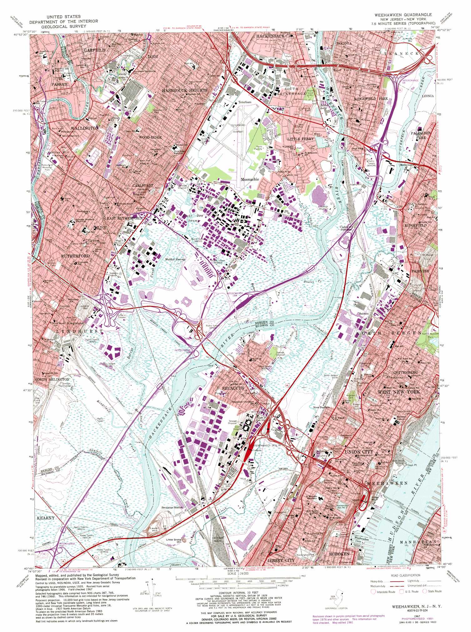
Weehawken Topo Map New Jersey
To zoom in, hover over the map of Weehawken
USGS Topo Quad 40074g1 - 1:24,000 scale
| Topo Map Name: | Weehawken |
| USGS Topo Quad ID: | 40074g1 |
| Print Size: | ca. 21 1/4" wide x 27" high |
| Southeast Coordinates: | 40.75° N latitude / 74° W longitude |
| Map Center Coordinates: | 40.8125° N latitude / 74.0625° W longitude |
| U.S. States: | NJ, NY |
| Filename: | o40074g1.jpg |
| Download Map JPG Image: | Weehawken topo map 1:24,000 scale |
| Map Type: | Topographic |
| Topo Series: | 7.5´ |
| Map Scale: | 1:24,000 |
| Source of Map Images: | United States Geological Survey (USGS) |
| Alternate Map Versions: |
Weehawken NJ 1935 Download PDF Buy paper map Weehawken NJ 1967, updated 1968 Download PDF Buy paper map Weehawken NJ 1967, updated 1982 Download PDF Buy paper map Weehawken NJ 1967, updated 1989 Download PDF Buy paper map Weehawken NJ 1995, updated 1998 Download PDF Buy paper map Weehawken NJ 2011 Download PDF Buy paper map Weehawken NJ 2014 Download PDF Buy paper map Weehawken NJ 2016 Download PDF Buy paper map |
1:24,000 Topo Quads surrounding Weehawken
Wanaque |
Ramsey |
Park Ridge |
Nyack |
White Plains |
Pompton Plains |
Paterson |
Hackensack |
Yonkers |
Mount Vernon |
Caldwell |
Orange |
Weehawken |
Central Park |
Flushing |
Roselle |
Elizabeth |
Jersey City |
Brooklyn |
Jamaica |
Perth Amboy |
Arthur Kill |
The Narrows |
Coney Island |
Far Rockaway |
> Back to 40074e1 at 1:100,000 scale
> Back to 40074a1 at 1:250,000 scale
> Back to U.S. Topo Maps home
Weehawken topo map: Gazetteer
Weehawken: Airports
Arcorp Properties Heliport elevation 1m 3′Lincoln Tunnel Heliport elevation 10m 32′
Little Ferry Seaplane Base elevation 1m 3′
Meadowlands Hospital Medical Center Heliport elevation 1m 3′
New Jersey Sports and Exposition Authority elevation 1m 3′
Passaic River Seaplane Base elevation 4m 13′
Pfister Helistop elevation 2m 6′
Port Authority-West 30th Street Midtown Heliport elevation 3m 9′
Ridgefield Park Seaplane Base elevation 0m 0′
Sky Harbor Seaplane Terminal elevation 1m 3′
Teterboro Airport elevation 2m 6′
Violas Helistop elevation 2m 6′
Weehawken: Bays
Weehawken Cove elevation 0m 0′Weehawken: Canals
Berrys Creek Canal elevation 0m 0′Jersey City Aqueduct elevation 3m 9′
Weehawken: Capes
Days Point elevation 1m 3′Weehawken: Channels
Garretts Reach elevation 0m 0′Rutherford Reach elevation 0m 0′
Wallington Reach elevation 0m 0′
Weehawken: Crossings
Interchange 1 elevation 5m 16′Interchange 15W elevation 2m 6′
Interchange 16E elevation 6m 19′
Interchange 16W elevation 1m 3′
Interchange 17 elevation 6m 19′
Interchange 18W elevation 1m 3′
Interchange 2 elevation 47m 154′
Interchange 3 elevation 43m 141′
Interchange 65 elevation 6m 19′
Interchange 66 elevation 5m 16′
Interchange 67 elevation 14m 45′
Interchange 68 elevation 7m 22′
Interchange 69 elevation 5m 16′
Weehawken: Lakes
Willow Lake elevation 0m 0′Weehawken: Parks
Amman Park elevation 22m 72′Armory Park elevation 12m 39′
Chelsea Park elevation 5m 16′
Columbia Park elevation 41m 134′
Columbus Park elevation 45m 147′
Columbus Park elevation 4m 13′
Donnelly Memorial Park elevation 44m 144′
Eightysecond Street Park elevation 41m 134′
Elsworth Park elevation 61m 200′
Elysian Park elevation 5m 16′
Fountain Park elevation 2m 6′
Giants Stadium elevation 1m 3′
Hackensack Meadowlands Conservation and Wildlife Area elevation 1m 3′
Hamilton Park elevation 48m 157′
James L Braddock North Hudson County Park elevation 64m 209′
Joseph Marin Field elevation 67m 219′
Lakeview Field elevation 0m 0′
Laurel Hill County Park elevation 50m 164′
Legion Park elevation 3m 9′
Lincoln Park elevation 29m 95′
Lindbergh Field elevation 39m 127′
Lyndhurst Municipal Park elevation 11m 36′
Meadowlands Sports Complex elevation 1m 3′
Memorial Park elevation 47m 154′
Miller Park elevation 57m 187′
Miller Stadium elevation 54m 177′
Old Glory Park elevation 19m 62′
Overpeck Marine Park elevation 3m 9′
Pulaski Park elevation 4m 13′
Pulaski Park elevation 3m 9′
Richard W De Korte Park elevation 1m 3′
Riggin Memorial Field elevation 2m 6′
Robert Allen Field elevation 59m 193′
Roosevelt Stadium (historical) elevation 59m 193′
Rutherford Memorial Park elevation 4m 13′
Rutherford Park elevation 1m 3′
Saint Mary's Park elevation 78m 255′
Samuel Nelkin County Park elevation 19m 62′
Schmidts Woods Park elevation 3m 9′
Schuetzen Park elevation 50m 164′
Shetik Field elevation 12m 39′
Shipyard Park elevation 4m 13′
Shipyard Piers elevation 1m 3′
Tamblyn Field elevation 20m 65′
Terrace Avenue Park elevation 22m 72′
Trolley Park elevation 1m 3′
Veteran's Memorial Park elevation 47m 154′
Wallington County Park elevation 6m 19′
Washington Park elevation 51m 167′
Washington Park elevation 68m 223′
Willis Park elevation 3m 9′
Woodland Park elevation 33m 108′
Weehawken: Populated Places
Babbitt elevation 3m 9′Carlstadt elevation 55m 180′
Carlton Hill elevation 13m 42′
East Rutherford elevation 24m 78′
Guttenberg elevation 61m 200′
Hasbrouck Heights elevation 41m 134′
Hudson Heights elevation 67m 219′
Kingsland elevation 28m 91′
Little Ferry elevation 3m 9′
Lyndhurst elevation 10m 32′
Metropolitan Mobile Home Park elevation 1m 3′
Moonachie elevation 1m 3′
Morsemere elevation 9m 29′
New Durham elevation 6m 19′
North Bergen elevation 64m 209′
Ridgefield elevation 13m 42′
Ridgefield Park elevation 26m 85′
Rutherford elevation 28m 91′
Secaucus elevation 4m 13′
South Hackensack elevation 3m 9′
Teterboro elevation 3m 9′
Undercliff Junction elevation 3m 9′
Union City elevation 53m 173′
Vanguard Mobile Home Park elevation 1m 3′
Wallington elevation 4m 13′
Weehawken elevation 50m 164′
West New York elevation 53m 173′
West View elevation 15m 49′
Wood-Ridge elevation 53m 173′
Weehawken: Post Offices
Carlstadt Post Office elevation 44m 144′Guttenberg Post Office elevation 58m 190′
Hasbrouck Heights Post Office elevation 37m 121′
Little Ferry Post Office elevation 2m 6′
Lyndhurst Post Office elevation 10m 32′
Ridgefield Park Post Office elevation 17m 55′
Rutherford Post Office elevation 28m 91′
South Hackensack Post Office elevation 3m 9′
Union City Post Office elevation 55m 180′
Uptown Station Hoboken Post Office elevation 2m 6′
Wallington Post Office elevation 4m 13′
West New York Post Office elevation 55m 180′
Wood Ridge Post Office elevation 43m 141′
Weehawken: Reservoirs
Hackensack Reservoir Number One elevation 48m 157′Hackensack Reservoir Number Two elevation 58m 190′
Indian Lake elevation 1m 3′
Weehawken: Streams
Ackermans Creek elevation 0m 0′Anderson Creek elevation 1m 3′
Bashes Creek elevation 1m 3′
Bellmans Creek elevation 1m 3′
Berrys Creek elevation 0m 0′
Cedar Creek elevation 3m 9′
Close Creek elevation 0m 0′
Cromakill Creek elevation 0m 0′
Doctor Creek elevation 0m 0′
Fish Creek elevation 1m 3′
Kingsland Creek elevation 0m 0′
Losen Slofe elevation 1m 3′
Mary Ann Creek elevation 0m 0′
Mill Creek elevation 0m 0′
Moonachie Creek elevation 0m 0′
Overpeck Creek elevation 1m 3′
Paunpeck Creek elevation 0m 0′
Peach Island Creek elevation 0m 0′
Penhorn Creek elevation 1m 3′
Riser Ditch elevation 1m 3′
Saddle River elevation 1m 3′
Saddle River elevation 0m 0′
Sawmill Creek elevation 1m 3′
Skeetkill Creek elevation 5m 16′
Teaneck Creek elevation 1m 3′
Ten Penny Creek elevation 0m 0′
Vreeland Ditch elevation 1m 3′
Williams Creek elevation 2m 6′
Wolf Creek elevation 0m 0′
Weehawken: Summits
Kings Bluff elevation 48m 157′Laurel Hill elevation 60m 196′
Weehawken: Swamps
Eight Day Swamp elevation 1m 3′Walden Swamp elevation 1m 3′
Weehawken: Tunnels
Lincoln Tunnel elevation 0m 0′New York Susquehanna and Western Tunnel elevation 67m 219′
Weehawken: Woods
Schmidts Woods elevation 4m 13′Weehawken digital topo map on disk
Buy this Weehawken topo map showing relief, roads, GPS coordinates and other geographical features, as a high-resolution digital map file on DVD:
Atlantic Coast (NY, NJ, PA, DE, MD, VA, NC)
Buy digital topo maps: Atlantic Coast (NY, NJ, PA, DE, MD, VA, NC)
 map DVD")