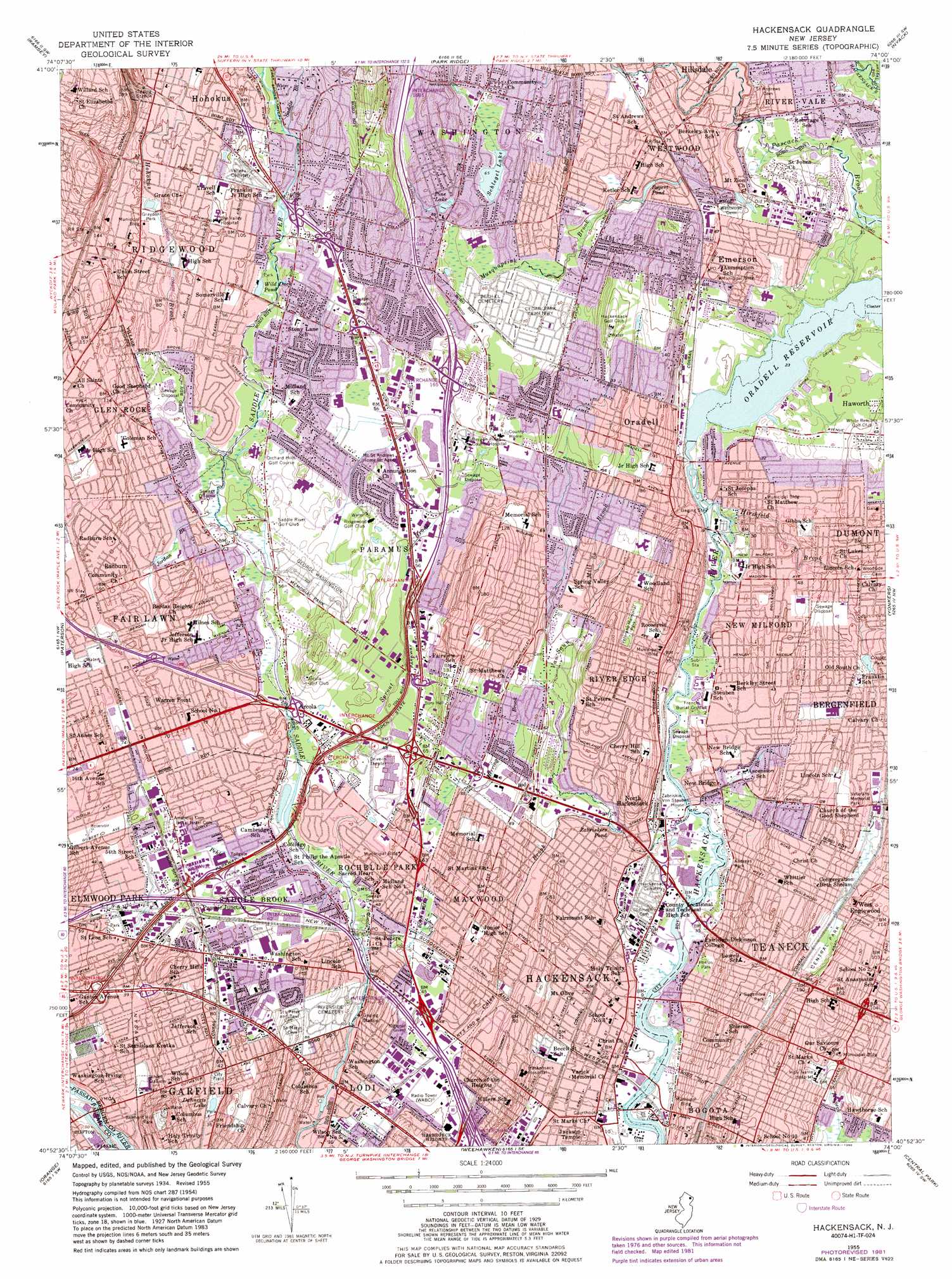
Hackensack Topo Map New Jersey
To zoom in, hover over the map of Hackensack
USGS Topo Quad 40074h1 - 1:24,000 scale
| Topo Map Name: | Hackensack |
| USGS Topo Quad ID: | 40074h1 |
| Print Size: | ca. 21 1/4" wide x 27" high |
| Southeast Coordinates: | 40.875° N latitude / 74° W longitude |
| Map Center Coordinates: | 40.9375° N latitude / 74.0625° W longitude |
| U.S. State: | NJ |
| Filename: | o40074h1.jpg |
| Download Map JPG Image: | Hackensack topo map 1:24,000 scale |
| Map Type: | Topographic |
| Topo Series: | 7.5´ |
| Map Scale: | 1:24,000 |
| Source of Map Images: | United States Geological Survey (USGS) |
| Alternate Map Versions: |
Hackensack NJ 1934 Download PDF Buy paper map Hackensack NJ 1955, updated 1965 Download PDF Buy paper map Hackensack NJ 1955, updated 1972 Download PDF Buy paper map Hackensack NJ 1955, updated 1982 Download PDF Buy paper map Hackensack NJ 1955, updated 1986 Download PDF Buy paper map Hackensack NJ 1997, updated 1998 Download PDF Buy paper map Hackensack NJ 2011 Download PDF Buy paper map Hackensack NJ 2014 Download PDF Buy paper map Hackensack NJ 2016 Download PDF Buy paper map |
1:24,000 Topo Quads surrounding Hackensack
Greenwood Lake |
Sloatsburg |
Thiells |
Haverstraw |
Ossining |
Wanaque |
Ramsey |
Park Ridge |
Nyack |
White Plains |
Pompton Plains |
Paterson |
Hackensack |
Yonkers |
Mount Vernon |
Caldwell |
Orange |
Weehawken |
Central Park |
Flushing |
Roselle |
Elizabeth |
Jersey City |
Brooklyn |
Jamaica |
> Back to 40074e1 at 1:100,000 scale
> Back to 40074a1 at 1:250,000 scale
> Back to U.S. Topo Maps home
Hackensack topo map: Gazetteer
Hackensack: Airports
Alexanders-Paramus Heliport elevation 15m 49′Bendelius elevation 20m 65′
Creamer Heliport elevation 1m 3′
Hackensack Medical Center Heliport elevation 15m 49′
Lags Landing Heliport elevation 15m 49′
Penske 2 Heliport elevation 11m 36′
Hackensack: Crossings
Interchange 157 elevation 13m 42′Interchange 159 elevation 15m 49′
Interchange 160 elevation 17m 55′
Interchange 161 elevation 18m 59′
Interchange 163 elevation 18m 59′
Interchange 165 elevation 23m 75′
Interchange 166 elevation 24m 78′
Interchange 168 elevation 34m 111′
Interchange 62 elevation 14m 45′
Interchange 63 elevation 18m 59′
Interchange 64 elevation 20m 65′
Hackensack: Dams
Oradell Reservoir Dam elevation 2m 6′Hackensack: Lakes
Dahnerts Lake elevation 10m 32′Wild Duck Pond elevation 21m 68′
Hackensack: Parks
Anderson Park elevation 6m 19′Andreas Park elevation 6m 19′
Baldwin Park elevation 6m 19′
Belmont Hill Park elevation 44m 144′
Berdan Grove elevation 21m 68′
Bergen County Zoological Park elevation 15m 49′
Brookdale Park elevation 17m 55′
Carver Park elevation 6m 19′
Clarence W Brett Park elevation 6m 19′
Constitution Grove Park elevation 33m 108′
Cooper Park elevation 16m 52′
Dahnert's Lake County Park elevation 10m 32′
Fairmount Park elevation 3m 9′
Faschini Park elevation 1m 3′
Fireman's Park elevation 15m 49′
George W Hodgins Stadium elevation 24m 78′
Graydon Park elevation 24m 78′
Gregory Park elevation 21m 68′
Hackensack River County Park elevation 1m 3′
Herrick Park elevation 32m 104′
Johnson Park elevation 1m 3′
Memorial Park elevation 25m 82′
Milton Votee Park elevation 23m 75′
Paramus Park elevation 16m 52′
Pascack Brook County Park elevation 9m 29′
Petruska Park elevation 18m 59′
Phelps Park elevation 6m 19′
Riverside Park elevation 1m 3′
Saddle River County Park elevation 18m 59′
Sagamore Park elevation 28m 91′
Sirianni Park elevation 18m 59′
Staib Park elevation 7m 22′
Stevens Avenue Park elevation 19m 62′
Terhune Park elevation 4m 13′
Tokoika Park elevation 16m 52′
Van Saun County Park elevation 8m 26′
Veterans Memorial Field elevation 24m 78′
Waymele Park elevation 17m 55′
Windsor Park elevation 20m 65′
Hackensack: Populated Places
Arcola elevation 16m 52′Bogota elevation 16m 52′
Cherry Hill elevation 26m 85′
Costa Mobile Home Park elevation 8m 26′
Elmwood Park elevation 14m 45′
Emerson elevation 14m 45′
Garfield elevation 9m 29′
Hackensack elevation 6m 19′
Ho-Ho-Kus elevation 38m 124′
Lodi elevation 8m 26′
Maywood elevation 30m 98′
New Bridge elevation 5m 16′
New Milford elevation 9m 29′
North Hackensack elevation 28m 91′
Oradell elevation 27m 88′
Paramus elevation 20m 65′
Passaic Junction elevation 16m 52′
Radburn elevation 28m 91′
Ridgewood elevation 35m 114′
River Edge elevation 17m 55′
River Vale elevation 17m 55′
Rochelle Park elevation 17m 55′
Saddle Brook elevation 14m 45′
Teaneck elevation 35m 114′
Warren Point elevation 21m 68′
West Englewood elevation 29m 95′
Westwood elevation 22m 72′
Hackensack: Post Offices
Bogota Post Office elevation 17m 55′Emerson Post Office elevation 15m 49′
Oradell Post Office elevation 9m 29′
Ridgewood Post Office elevation 34m 111′
River Edge Post Office elevation 18m 59′
Westwood Post Office elevation 22m 72′
Hackensack: Reservoirs
Bogert Pond elevation 13m 42′Cooper Pond elevation 16m 52′
Oradell Reservoir elevation 2m 6′
Pine Lake elevation 24m 78′
Schlegel Lake elevation 19m 62′
Zabriskies Pond elevation 4m 13′
Hackensack: Streams
Beaverdam Brook elevation 14m 45′Behnke Brook elevation 9m 29′
Coalberg Brook elevation 12m 39′
Coles Brook elevation 4m 13′
Fleischer Brook elevation 2m 6′
French Brook elevation 2m 6′
Herring Brook elevation 8m 26′
Hirshfeld Brook elevation 1m 3′
Hohokus Brook elevation 15m 49′
Jordan Brook elevation 13m 42′
Musquapsink Brook elevation 8m 26′
Pehle Brook elevation 11m 36′
Prospect Brook elevation 18m 59′
Saddle Brook elevation 26m 85′
Saint Andrews Brook elevation 15m 49′
Sprout Brook elevation 11m 36′
Van Saun Mill Brook elevation 5m 16′
Zabriskie Brook elevation 30m 98′
Hackensack digital topo map on disk
Buy this Hackensack topo map showing relief, roads, GPS coordinates and other geographical features, as a high-resolution digital map file on DVD:
Atlantic Coast (NY, NJ, PA, DE, MD, VA, NC)
Buy digital topo maps: Atlantic Coast (NY, NJ, PA, DE, MD, VA, NC)
 map DVD")