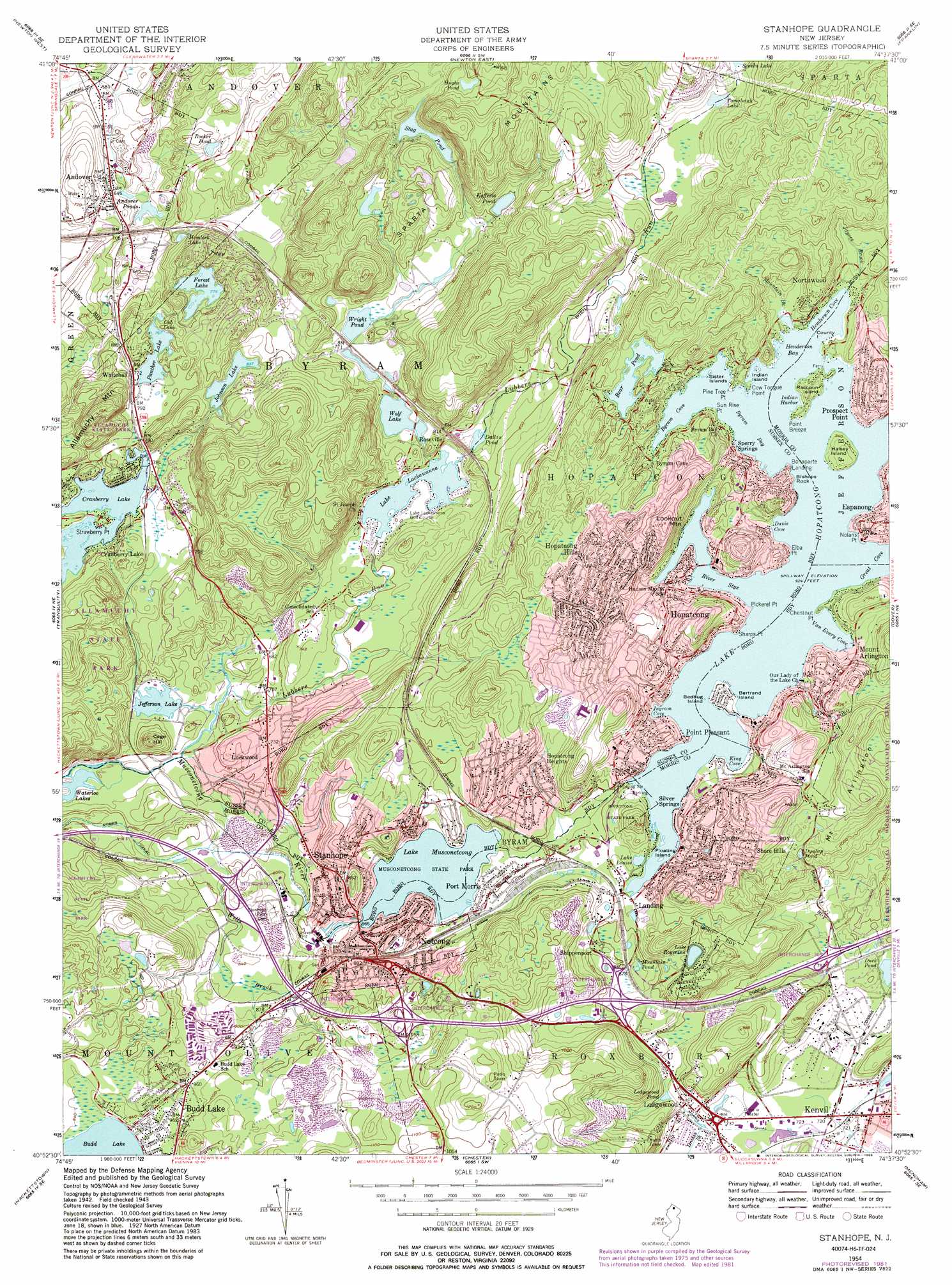
Stanhope Topo Map New Jersey
To zoom in, hover over the map of Stanhope
USGS Topo Quad 40074h6 - 1:24,000 scale
| Topo Map Name: | Stanhope |
| USGS Topo Quad ID: | 40074h6 |
| Print Size: | ca. 21 1/4" wide x 27" high |
| Southeast Coordinates: | 40.875° N latitude / 74.625° W longitude |
| Map Center Coordinates: | 40.9375° N latitude / 74.6875° W longitude |
| U.S. State: | NJ |
| Filename: | o40074h6.jpg |
| Download Map JPG Image: | Stanhope topo map 1:24,000 scale |
| Map Type: | Topographic |
| Topo Series: | 7.5´ |
| Map Scale: | 1:24,000 |
| Source of Map Images: | United States Geological Survey (USGS) |
| Alternate Map Versions: |
Stanhope NJ 1954, updated 1957 Download PDF Buy paper map Stanhope NJ 1954, updated 1965 Download PDF Buy paper map Stanhope NJ 1954, updated 1972 Download PDF Buy paper map Stanhope NJ 1954, updated 1981 Download PDF Buy paper map Stanhope NJ 1954, updated 1986 Download PDF Buy paper map Stanhope NJ 1995, updated 2000 Download PDF Buy paper map Stanhope NJ 2011 Download PDF Buy paper map Stanhope NJ 2014 Download PDF Buy paper map Stanhope NJ 2016 Download PDF Buy paper map |
1:24,000 Topo Quads surrounding Stanhope
Lake Maskenozha |
Culvers Gap |
Branchville |
Hamburg |
Wawayanda |
Flatbrookville |
Newton West |
Newton East |
Franklin |
Newfoundland |
Blairstown |
Tranquility |
Stanhope |
Dover |
Boonton |
Washington |
Hackettstown |
Chester |
Mendham |
Morristown |
High Bridge |
Califon |
Gladstone |
Bernardsville |
Chatham |
> Back to 40074e1 at 1:100,000 scale
> Back to 40074a1 at 1:250,000 scale
> Back to U.S. Topo Maps home
Stanhope topo map: Gazetteer
Stanhope: Airports
Fla-Net Airport elevation 314m 1030′Trade Zone Heliport elevation 254m 833′
Westby Heliport elevation 254m 833′
Stanhope: Bays
Byram Bay elevation 282m 925′Byram Cove elevation 282m 925′
Davis Cove elevation 282m 925′
Great Cove elevation 282m 925′
Henderson Bay elevation 282m 925′
Henderson Cove elevation 282m 925′
Indian Harbor elevation 282m 925′
Ingram Cove elevation 282m 925′
King Cove elevation 282m 925′
River Styx elevation 282m 925′
Van Every Cove elevation 282m 925′
Stanhope: Capes
Bishops Rock elevation 282m 925′Chestnut Point elevation 284m 931′
Cow Tongue Point elevation 285m 935′
Elba Point elevation 284m 931′
Nolans Point elevation 286m 938′
Pickerel Point elevation 286m 938′
Pine Tree Point elevation 285m 935′
Point Breeze elevation 286m 938′
Sharps Point elevation 286m 938′
Strawberry Point elevation 236m 774′
Sun Rise Point elevation 285m 935′
Stanhope: Crossings
Interchange 25 elevation 244m 800′Interchange 26 elevation 272m 892′
Interchange 27 elevation 310m 1017′
Interchange 28 elevation 262m 859′
Interchange 30 elevation 237m 777′
Stanhope: Dams
Cranberry Lake Dam elevation 234m 767′Forest Lake Dam elevation 239m 784′
Hemlock Lake Dam elevation 217m 711′
Jefferson Lake Dam elevation 201m 659′
Johnson Lake Dam elevation 254m 833′
Kofferls Pond Dam elevation 244m 800′
Lake Hopatcong Dam elevation 288m 944′
Lake Lackawanna Dam elevation 214m 702′
Lake Musconetcong Dam elevation 259m 849′
Tomahawk Lake Dam elevation 246m 807′
Stanhope: Islands
Bedbug Island elevation 283m 928′Bertrand Island elevation 293m 961′
County Island elevation 282m 925′
Floating Island elevation 283m 928′
Halsey Island elevation 299m 980′
Indian Island elevation 284m 931′
Raccoon Island elevation 300m 984′
Sister Islands elevation 284m 931′
Stanhope: Lakes
Bear Pond elevation 294m 964′Cub Lake elevation 233m 764′
Dunlap Pond elevation 303m 994′
Hughs Pond elevation 278m 912′
Lake Louise elevation 283m 928′
Lake Rogerene elevation 283m 928′
Ledgewood Pond elevation 238m 780′
Mountain Lake elevation 261m 856′
Mountain Pond elevation 262m 859′
Panther Lake elevation 233m 764′
Stag Pond elevation 248m 813′
Wolf Lake elevation 225m 738′
Stanhope: Mines
Byram Quarry elevation 265m 869′Stanhope: Parks
Allamuchy State Park elevation 231m 757′Bertrand Island Amusement Park (historical) elevation 286m 938′
Budd Lake State Wildlife Management Area elevation 286m 938′
Hopatcong State Park elevation 295m 967′
Lee's County Park elevation 285m 935′
Musconetcong State Park elevation 259m 849′
Stanhope: Populated Places
Andover elevation 197m 646′Andover Junction elevation 178m 583′
Bonaparte Landing elevation 289m 948′
Byram Cove elevation 284m 931′
Cranberry Lake elevation 240m 787′
Hopatcong elevation 310m 1017′
Hopatcong Heights elevation 281m 921′
Hopatcong Hills elevation 336m 1102′
Landing elevation 281m 921′
Ledgewood elevation 234m 767′
Lockwood elevation 217m 711′
Mount Arlington elevation 309m 1013′
Netcong elevation 264m 866′
Northwood elevation 301m 987′
Point Pleasant elevation 302m 990′
Port Morris elevation 273m 895′
Prospect Point elevation 315m 1033′
Roseville elevation 239m 784′
Shippenport elevation 282m 925′
Shore Hills elevation 286m 938′
Silver Springs elevation 292m 958′
South Netcong elevation 335m 1099′
Sperry Springs elevation 293m 961′
Stanhope elevation 255m 836′
Whitehall elevation 238m 780′
Stanhope: Reservoirs
Andover Ponds elevation 189m 620′Cranberry Lake elevation 234m 767′
Dallis Pond elevation 222m 728′
Forest Lake elevation 239m 784′
Hemlock Lake elevation 217m 711′
Jefferson Lake elevation 201m 659′
Johnson Lake elevation 254m 833′
Kofferls Pond elevation 244m 800′
Lake Hopatcong elevation 284m 931′
Lake Lackawanna elevation 214m 702′
Lake Musconetcong elevation 259m 849′
Rocker Pond elevation 229m 751′
Tomahawk Lake elevation 246m 807′
Wright Pond elevation 230m 754′
Stanhope: Streams
Cowboy Creek elevation 213m 698′Ghost Pony Brook elevation 231m 757′
Jayness Brook elevation 284m 931′
Lubbers Run elevation 197m 646′
Mountain Brook elevation 285m 935′
Punkhorn Creek elevation 228m 748′
Wills Brook elevation 208m 682′
Stanhope: Summits
Cage Hill elevation 258m 846′Lookout Mountain elevation 355m 1164′
Mount Arlington elevation 371m 1217′
Stanhope digital topo map on disk
Buy this Stanhope topo map showing relief, roads, GPS coordinates and other geographical features, as a high-resolution digital map file on DVD:
Atlantic Coast (NY, NJ, PA, DE, MD, VA, NC)
Buy digital topo maps: Atlantic Coast (NY, NJ, PA, DE, MD, VA, NC)
 map DVD")