Germantown Topo Map Pennsylvania
To zoom in, hover over the map of Germantown
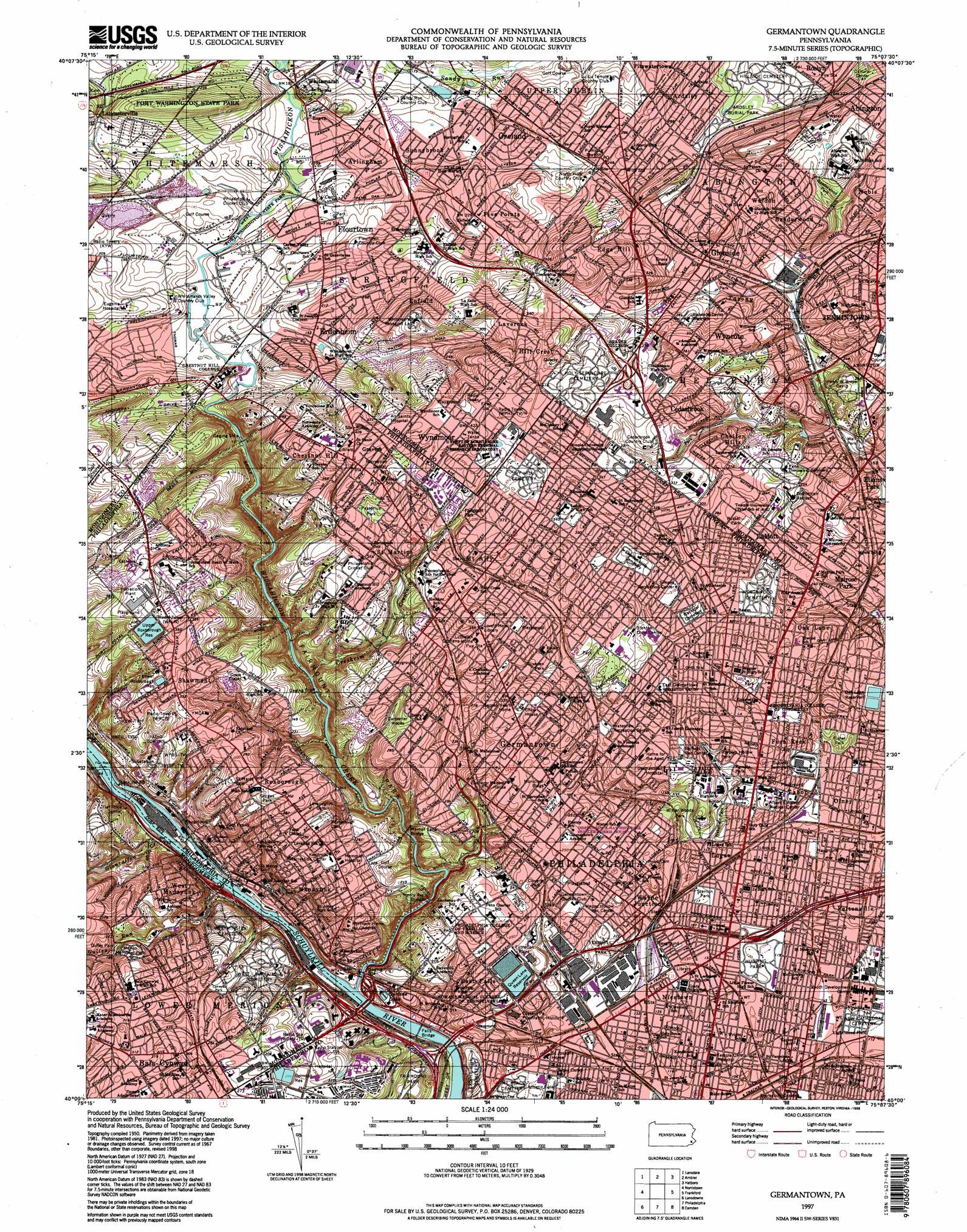
USGS Topo Quad 40075a2 - 1:24,000 scale
| Topo Map Name: | Germantown |
| USGS Topo Quad ID: | 40075a2 |
| Print Size: | ca. 21 1/4" wide x 27" high |
| Southeast Coordinates: | 40° N latitude / 75.125° W longitude |
| Map Center Coordinates: | 40.0625° N latitude / 75.1875° W longitude |
| U.S. State: | PA |
| Filename: | o40075a2.jpg |
| Download Map JPG Image: | Germantown topo map 1:24,000 scale |
| Map Type: | Topographic |
| Topo Series: | 7.5´ |
| Map Scale: | 1:24,000 |
| Source of Map Images: | United States Geological Survey (USGS) |
| Alternate Map Versions: |
Germantown PA 1952, updated 1954 Download PDF Buy paper map Germantown PA 1952, updated 1961 Download PDF Buy paper map Germantown PA 1967, updated 1969 Download PDF Buy paper map Germantown PA 1967, updated 1974 Download PDF Buy paper map Germantown PA 1967, updated 1984 Download PDF Buy paper map Germantown PA 1967, updated 1988 Download PDF Buy paper map Germantown PA 1997, updated 1998 Download PDF Buy paper map Germantown PA 2010 Download PDF Buy paper map Germantown PA 2013 Download PDF Buy paper map Germantown PA 2016 Download PDF Buy paper map |
1:24,000 Topo Quads surrounding Germantown
Perkiomenville |
Telford |
Doylestown |
Buckingham |
Lambertville |
Collegeville |
Lansdale |
Ambler |
Hatboro |
Langhorne |
Valley Forge |
Norristown |
Germantown |
Frankford |
Beverly |
Media |
Lansdowne |
Philadelphia |
Camden |
Moorestown |
Marcus Hook |
Bridgeport |
Woodbury |
Runnemede |
Clementon |
> Back to 40075a1 at 1:100,000 scale
> Back to 40074a1 at 1:250,000 scale
> Back to U.S. Topo Maps home
Germantown topo map: Gazetteer
Germantown: Airports
T N Ward Airport elevation 81m 265′Tastykake Airport elevation 39m 127′
WCAU Heliport elevation 72m 236′
Germantown: Bridges
Falls Bridge elevation 7m 22′Green Lane Bridge elevation 3m 9′
Henry Avenue Bridge elevation 14m 45′
Pencoyd Bridge elevation 3m 9′
Walnut Lane Bridge elevation 26m 85′
Germantown: Crossings
Interchange 338 elevation 15m 49′Interchange 339 elevation 39m 127′
Interchange 340A elevation 33m 108′
Interchange 340B elevation 35m 114′
Germantown: Dams
Campbell Dam elevation 83m 272′Flat Rock Dam elevation 6m 19′
Joyce Dam elevation 47m 154′
Lock Number Sixty-Eight elevation 6m 19′
Margaree Dam elevation 26m 85′
Morris Dam elevation 39m 127′
Germantown: Falls
Falls of Schuylkill elevation 3m 9′The Grotto elevation 84m 275′
Germantown: Lakes
Devils Pool elevation 28m 91′Gustine Lake elevation 19m 62′
Germantown: Parks
Awbury Arboretum elevation 88m 288′Baederwood Park elevation 89m 291′
Belfield Playground elevation 69m 226′
Belfield Recreation Center elevation 58m 190′
Belmont Park elevation 97m 318′
Blankley Field elevation 96m 314′
Briarbush Nature Center elevation 108m 354′
Carpenter Park elevation 97m 318′
Carpenter Woods elevation 89m 291′
Clifford Park elevation 68m 223′
Cliveden Park elevation 81m 265′
Cloverly Park elevation 76m 249′
Curtis Arboretum elevation 81m 265′
Cynwyd Park elevation 70m 229′
East Germantown Recreation Center elevation 70m 229′
Fairmount Park elevation 33m 108′
Fernhill Park elevation 60m 196′
Fisher Park elevation 53m 173′
Fort Washington State Park elevation 100m 328′
George Perley Bird Sanctuary elevation 66m 216′
Glenside Park elevation 70m 229′
Gorgas Park elevation 95m 311′
Grove Park elevation 79m 259′
Gulley Park elevation 77m 252′
H Carroll Brooke Park elevation 104m 341′
Happy Hollow Recreation Center elevation 69m 226′
Harpers Hollow Park elevation 56m 183′
Hunting Park elevation 33m 108′
Kelly Playground elevation 70m 229′
Kemble Park elevation 54m 177′
Kendrick Playground elevation 80m 262′
Kendrick Recreation Center elevation 81m 265′
Lighthouse Field elevation 31m 101′
Lindley Playground elevation 37m 121′
Makefield Park elevation 44m 144′
Manayunk Park elevation 55m 180′
Mann Recreation Center elevation 29m 95′
Marcus Foster Memorial Stadium elevation 40m 131′
McCarthy Stadium elevation 62m 203′
Merion Memorial Park elevation 54m 177′
Morris Arboretum elevation 67m 219′
Mount Airy Playground elevation 113m 370′
Pastorius Park elevation 113m 370′
Penbryn Park elevation 108m 354′
Pleasant Playground elevation 99m 324′
Ravenhill Athletic Field elevation 59m 193′
Russel Park elevation 77m 252′
Scotts Playground elevation 35m 114′
Simons Playground elevation 93m 305′
Simons Recreation Center elevation 94m 308′
Stenton Park elevation 34m 111′
Thomas Williams Park elevation 91m 298′
Valley Green Park elevation 64m 209′
Vernon Park elevation 72m 236′
Wall Park elevation 54m 177′
Waterview Recreation Center elevation 72m 236′
Weiss Tennis Courts elevation 99m 324′
Wissahickon Valley Park elevation 46m 150′
Wister Woods Park elevation 43m 141′
Wyncote elevation 63m 206′
Germantown: Populated Places
Abbotsford Homes elevation 40m 131′Academyville elevation 97m 318′
Alden Park Manor elevation 71m 232′
Allegheny West elevation 39m 127′
Allen Lane elevation 99m 324′
Andorra elevation 111m 364′
Ardsley elevation 88m 288′
Arlingham elevation 58m 190′
Ashbourne elevation 62m 203′
Baederwood elevation 91m 298′
Bala-Cynwyd elevation 92m 301′
Benson East elevation 89m 291′
Breyer elevation 88m 288′
Carpenter elevation 104m 341′
Cedarbrook elevation 110m 360′
Cedarbrook Hill elevation 113m 370′
Chelten Hills elevation 94m 308′
Chestnut Hill elevation 134m 439′
Chopersville elevation 30m 98′
Cynwyd elevation 79m 259′
Cynwyd Estates elevation 94m 308′
East Falls elevation 45m 147′
East Mount Airy elevation 102m 334′
East Oak Lane elevation 59m 193′
East Oreland elevation 70m 229′
Edge Hill elevation 93m 305′
Elkins Park elevation 48m 157′
Elkins Park House elevation 76m 249′
Enfield elevation 92m 301′
Erdenheim elevation 50m 164′
Fellwick elevation 54m 177′
Feltonville elevation 32m 104′
Fern Rock elevation 61m 200′
Fishers elevation 49m 160′
Fitzwatertown elevation 76m 249′
Five Points elevation 71m 232′
Flourtown elevation 57m 187′
Franklinville elevation 30m 98′
Germantown elevation 89m 291′
Glen Willow elevation 82m 269′
Glenside elevation 80m 262′
Gravers elevation 121m 396′
Highland elevation 119m 390′
Hill Crest elevation 100m 328′
Hillside (historical) elevation 100m 328′
Hunting Park elevation 36m 118′
Ivy Hill elevation 119m 390′
Jenkintown elevation 98m 321′
Kennedy House elevation 109m 357′
Lamott elevation 70m 229′
Lancasterville elevation 58m 190′
Latches Lane elevation 92m 301′
Laverock elevation 102m 334′
Logan elevation 38m 124′
Lynnewood Gardens elevation 82m 269′
Lynnwood Gardens elevation 74m 242′
Manatawna elevation 112m 367′
Manayunk elevation 50m 164′
McMoran Park elevation 70m 229′
Melrose Park elevation 62m 203′
Mermaid elevation 119m 390′
Morton elevation 86m 282′
Mount Airy elevation 100m 328′
Mount Pleasant elevation 94m 308′
Mount Vernon Gardens elevation 102m 334′
Nicetown elevation 39m 127′
Nicetown-Tioga elevation 44m 144′
North Hills elevation 75m 246′
Oak Summit elevation 81m 265′
Oreland elevation 79m 259′
Pencoyd elevation 84m 275′
Pencoyd Park elevation 49m 160′
Penn Weldy elevation 74m 242′
Pittville elevation 72m 236′
Rittenhouse Town elevation 69m 226′
Rosemore Gardens elevation 99m 324′
Roslyn Heights elevation 107m 351′
Roxborough elevation 91m 298′
Saint Martins elevation 94m 308′
Shawmont elevation 111m 364′
Somerville elevation 75m 246′
Sunnybrook elevation 52m 170′
Sutton Terrace elevation 88m 288′
Tabor elevation 55m 180′
The Estates at Whitemarsh Hills elevation 74m 242′
Tioga elevation 40m 131′
Tulpohocken elevation 84m 275′
Upper Roxborough elevation 121m 396′
Upsal elevation 90m 295′
Valley Green elevation 52m 170′
Wayne Junction elevation 44m 144′
Weldon elevation 91m 298′
West Laurel Hill elevation 70m 229′
West Manayunk elevation 64m 209′
West Mount Airy elevation 100m 328′
West Oak Lane elevation 103m 337′
Whitemarsh elevation 56m 183′
Whitemarsh Woods elevation 50m 164′
Williams elevation 72m 236′
Wissahickon elevation 38m 124′
Wister elevation 59m 193′
Wyncote elevation 87m 285′
Wyndmoor elevation 128m 419′
Wynnefield Heights elevation 68m 223′
Wyoming elevation 29m 95′
Germantown: Post Offices
Bala Cynwyd Post Office elevation 84m 275′Chestnut Hill Station Post Office elevation 129m 423′
East Germantown Station Post Office elevation 75m 246′
Elkins Park Post Office elevation 58m 190′
Flourtown Post Office elevation 49m 160′
Germantown Station Post Office elevation 71m 232′
Glenside Post Office elevation 72m 236′
Hunting Park Station Post Office elevation 25m 82′
Jenkintown Post Office elevation 100m 328′
Logan Station Post Office elevation 60m 196′
Manayunk Station Post Office elevation 16m 52′
Market Square Station Post Office elevation 111m 364′
Mount Airy Station Post Office elevation 113m 370′
Nicetown Post Office elevation 39m 127′
Oreland Post Office elevation 68m 223′
Roxborough Post Office elevation 89m 291′
Roxborough Station Post Office elevation 83m 272′
Vernon Park Station Post Office elevation 76m 249′
Wadsworth Station Post Office elevation 117m 383′
Wyncote Post Office elevation 61m 200′
Germantown: Reservoirs
Belmount Reservoir elevation 92m 301′Lower Roxborough Reservoir elevation 114m 374′
Oak Lane Reservoir elevation 67m 219′
Queen Lane Reservoir elevation 74m 242′
Upper Roxborough Reservoir elevation 125m 410′
Germantown: Streams
Cresheim Creek elevation 28m 91′Glanraffan Creek elevation 3m 9′
Gulley Run elevation 3m 9′
Gunners Run (historical) elevation 36m 118′
Lorraine Run elevation 42m 137′
Wingohocking Creek (historical) elevation 29m 95′
Wissahickon Creek elevation 12m 39′
Germantown: Trails
Green Ribbon Preservation Trail elevation 45m 147′Germantown: Tunnels
Flat Rock Tunnel elevation 49m 160′Germantown: Valleys
Cresheim Valley elevation 28m 91′Germantown digital topo map on disk
Buy this Germantown topo map showing relief, roads, GPS coordinates and other geographical features, as a high-resolution digital map file on DVD:
Atlantic Coast (NY, NJ, PA, DE, MD, VA, NC)
Buy digital topo maps: Atlantic Coast (NY, NJ, PA, DE, MD, VA, NC)
 map DVD")