Downingtown Topo Map Pennsylvania
To zoom in, hover over the map of Downingtown
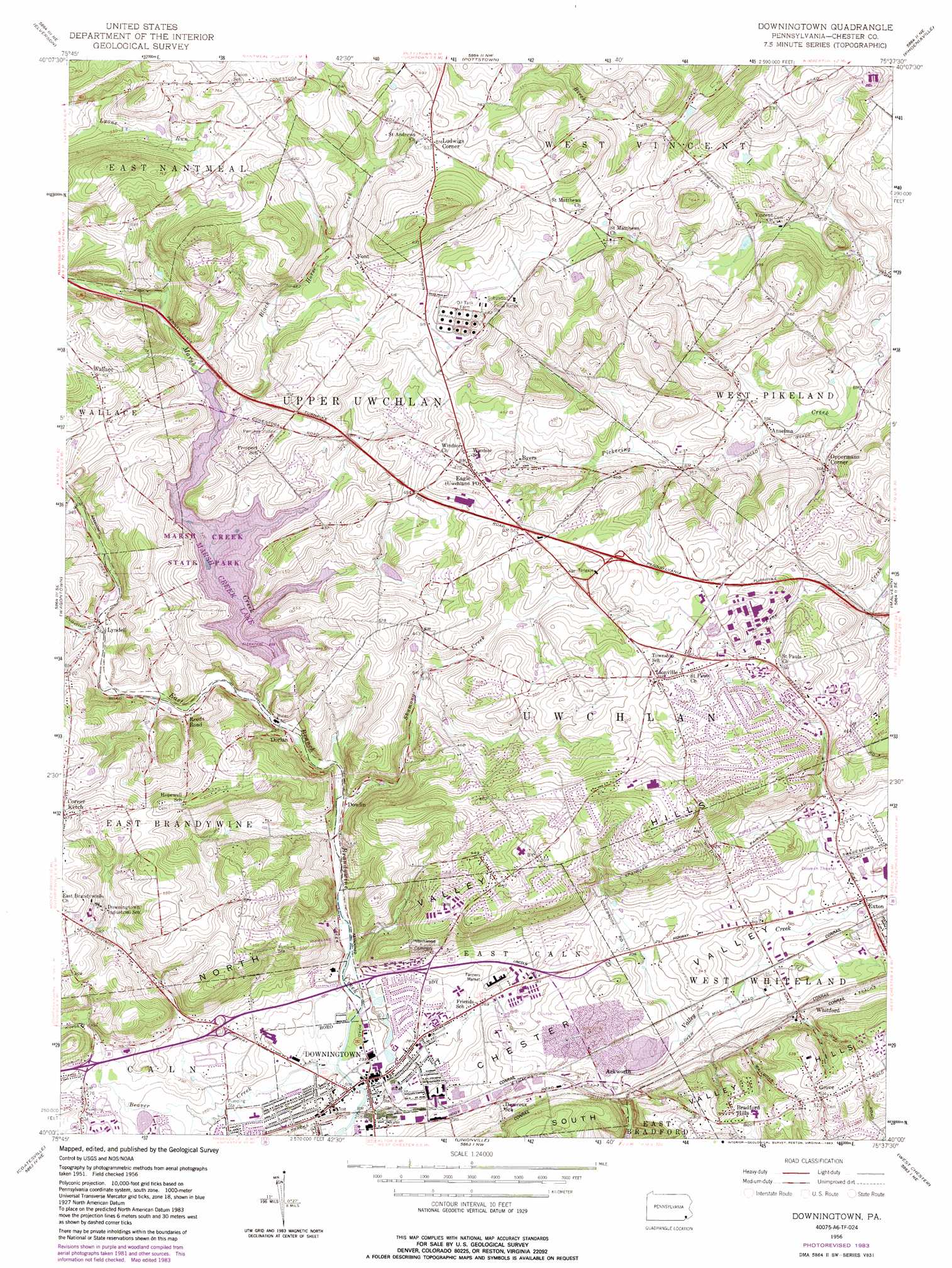
USGS Topo Quad 40075a6 - 1:24,000 scale
| Topo Map Name: | Downingtown |
| USGS Topo Quad ID: | 40075a6 |
| Print Size: | ca. 21 1/4" wide x 27" high |
| Southeast Coordinates: | 40° N latitude / 75.625° W longitude |
| Map Center Coordinates: | 40.0625° N latitude / 75.6875° W longitude |
| U.S. State: | PA |
| Filename: | o40075a6.jpg |
| Download Map JPG Image: | Downingtown topo map 1:24,000 scale |
| Map Type: | Topographic |
| Topo Series: | 7.5´ |
| Map Scale: | 1:24,000 |
| Source of Map Images: | United States Geological Survey (USGS) |
| Alternate Map Versions: |
Downingtown PA 1956, updated 1957 Download PDF Buy paper map Downingtown PA 1956, updated 1964 Download PDF Buy paper map Downingtown PA 1956, updated 1969 Download PDF Buy paper map Downingtown PA 1956, updated 1974 Download PDF Buy paper map Downingtown PA 1956, updated 1983 Download PDF Buy paper map Downingtown PA 1999, updated 2001 Download PDF Buy paper map Downingtown PA 2010 Download PDF Buy paper map Downingtown PA 2013 Download PDF Buy paper map Downingtown PA 2016 Download PDF Buy paper map |
1:24,000 Topo Quads surrounding Downingtown
Reading |
Birdsboro |
Boyertown |
Sassamansville |
Perkiomenville |
Morgantown |
Elverson |
Pottstown |
Phoenixville |
Collegeville |
Honey Brook |
Wagontown |
Downingtown |
Malvern |
Valley Forge |
Parkesburg |
Coatesville |
Unionville |
West Chester |
Media |
Oxford |
West Grove |
Kennett Square |
Wilmington North |
Marcus Hook |
> Back to 40075a1 at 1:100,000 scale
> Back to 40074a1 at 1:250,000 scale
> Back to U.S. Topo Maps home
Downingtown topo map: Gazetteer
Downingtown: Airports
Exton Airport elevation 94m 308′Fetters Construction Airport elevation 159m 521′
Downingtown: Basins
Hester Valley elevation 84m 275′Downingtown: Crossings
Interchange 312 elevation 156m 511′Pennsylvania Turnpike Interchange 23 elevation 157m 515′
Downingtown: Dams
Academy Dam elevation 93m 305′Beaver Creek Dam elevation 144m 472′
F Houston Mcilvain Dam elevation 124m 406′
Downingtown: Parks
Marsh Creek State Park elevation 140m 459′Downingtown: Populated Places
Ackworth elevation 81m 265′Anselma elevation 99m 324′
Belvidere elevation 95m 311′
Bradford Hills elevation 160m 524′
Byers elevation 131m 429′
Corner Ketch elevation 174m 570′
Dorlan elevation 85m 278′
Dowlin elevation 86m 282′
Downingtown elevation 71m 232′
Eagle elevation 148m 485′
East Nantmeal elevation 220m 721′
Grove elevation 159m 521′
Lionville elevation 165m 541′
Ludwigs Corner elevation 191m 626′
Lyndell elevation 101m 331′
Matthews elevation 126m 413′
Milford Mills elevation 109m 357′
Oakland elevation 88m 288′
Oppermans Corner elevation 105m 344′
Wallace elevation 172m 564′
Whitford elevation 106m 347′
Woodbine elevation 108m 354′
Downingtown: Post Offices
Lyndell Post Office elevation 99m 324′Uwchland Post Office elevation 165m 541′
West Vincent Post Office (historical) elevation 194m 636′
West Whiteland Post Office (historical) elevation 108m 354′
Whitford Post Office (historical) elevation 95m 311′
Downingtown: Ranges
North Valley Hills elevation 156m 511′South Valley Hills elevation 129m 423′
Downingtown: Reservoirs
Marsh Creek Reservoir elevation 99m 324′Downingtown: Streams
Beaver Creek elevation 71m 232′Black Horse Creek elevation 110m 360′
Culbertson Run elevation 97m 318′
Marsh Creek elevation 89m 291′
Shamona Creek elevation 82m 269′
Downingtown digital topo map on disk
Buy this Downingtown topo map showing relief, roads, GPS coordinates and other geographical features, as a high-resolution digital map file on DVD:
Atlantic Coast (NY, NJ, PA, DE, MD, VA, NC)
Buy digital topo maps: Atlantic Coast (NY, NJ, PA, DE, MD, VA, NC)
 map DVD")