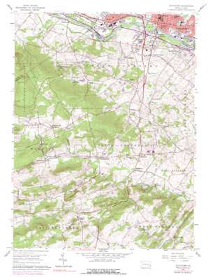
Pottstown Topo Map Pennsylvania
To zoom in, hover over the map of Pottstown
USGS Topo Quad 40075b6 - 1:24,000 scale
| Topo Map Name: | Pottstown |
| USGS Topo Quad ID: | 40075b6 |
| Print Size: | ca. 21 1/4" wide x 27" high |
| Southeast Coordinates: | 40.125° N latitude / 75.625° W longitude |
| Map Center Coordinates: | 40.1875° N latitude / 75.6875° W longitude |
| U.S. State: | PA |
| Filename: | o40075b6.jpg |
| Download Map JPG Image: | Pottstown topo map 1:24,000 scale |
| Map Type: | Topographic |
| Topo Series: | 7.5´ |
| Map Scale: | 1:24,000 |
| Source of Map Images: | United States Geological Survey (USGS) |
| Alternate Map Versions: |
Pottstown PA 1956, updated 1957 Download PDF Buy paper map Pottstown PA 1956, updated 1960 Download PDF Buy paper map Pottstown PA 1956, updated 1969 Download PDF Buy paper map Pottstown PA 1956, updated 1975 Download PDF Buy paper map Pottstown PA 1956, updated 1990 Download PDF Buy paper map Pottstown PA 1999, updated 2001 Download PDF Buy paper map Pottstown PA 2010 Download PDF Buy paper map Pottstown PA 2013 Download PDF Buy paper map Pottstown PA 2016 Download PDF Buy paper map |
1:24,000 Topo Quads surrounding Pottstown
> Back to 40075a1 at 1:100,000 scale
> Back to 40074a1 at 1:250,000 scale
> Back to U.S. Topo Maps home
Pottstown topo map: Gazetteer
Pottstown: Airports
E L Gruber Airport elevation 47m 154′Pottstown: Cliffs
Millers Point elevation 236m 774′Pottstown: Dams
Camp Innabah Dam elevation 71m 232′Park Dam elevation 83m 272′
Pottstown: Parks
Kenilworth Park elevation 48m 157′Manatawny Park elevation 42m 137′
State Game Land Number 43 elevation 149m 488′
Pottstown: Populated Places
Birchrunville elevation 118m 387′Bramcote elevation 49m 160′
Bucktown elevation 108m 354′
Cedarville elevation 80m 262′
Coventryville elevation 89m 291′
Harmonyville elevation 149m 488′
Kenilworth elevation 54m 177′
Knauertown elevation 94m 308′
Nantmeal Village elevation 136m 446′
Porters Mill elevation 66m 216′
Pottstown elevation 46m 150′
Pottstown Landing elevation 60m 196′
Pughtown elevation 85m 278′
Saint Peters elevation 131m 429′
Schades Corner elevation 84m 275′
Slonaker elevation 131m 429′
South Pottstown elevation 43m 141′
Titlows Corner elevation 74m 242′
Unionville elevation 50m 164′
Pottstown: Post Offices
Birchrunville Post Office elevation 95m 311′Coventry Post Office (historical) elevation 98m 321′
Pughtown Post Office (historical) elevation 85m 278′
Pottstown: Reservoirs
Neimans Pond elevation 44m 144′Rodebaugh Dam elevation 129m 423′
Pottstown: Streams
Beaver Run elevation 78m 255′Manatawny Creek elevation 39m 127′
Mill Creek elevation 38m 124′
Rock Run elevation 82m 269′
South Branch French Creek elevation 82m 269′
Pottstown: Summits
Sheep Hill elevation 151m 495′Pottstown: Trails
Buzzard Trail elevation 272m 892′Raccoon Trail elevation 229m 751′
Pottstown digital topo map on disk
Buy this Pottstown topo map showing relief, roads, GPS coordinates and other geographical features, as a high-resolution digital map file on DVD:
Atlantic Coast (NY, NJ, PA, DE, MD, VA, NC)
Buy digital topo maps: Atlantic Coast (NY, NJ, PA, DE, MD, VA, NC)


