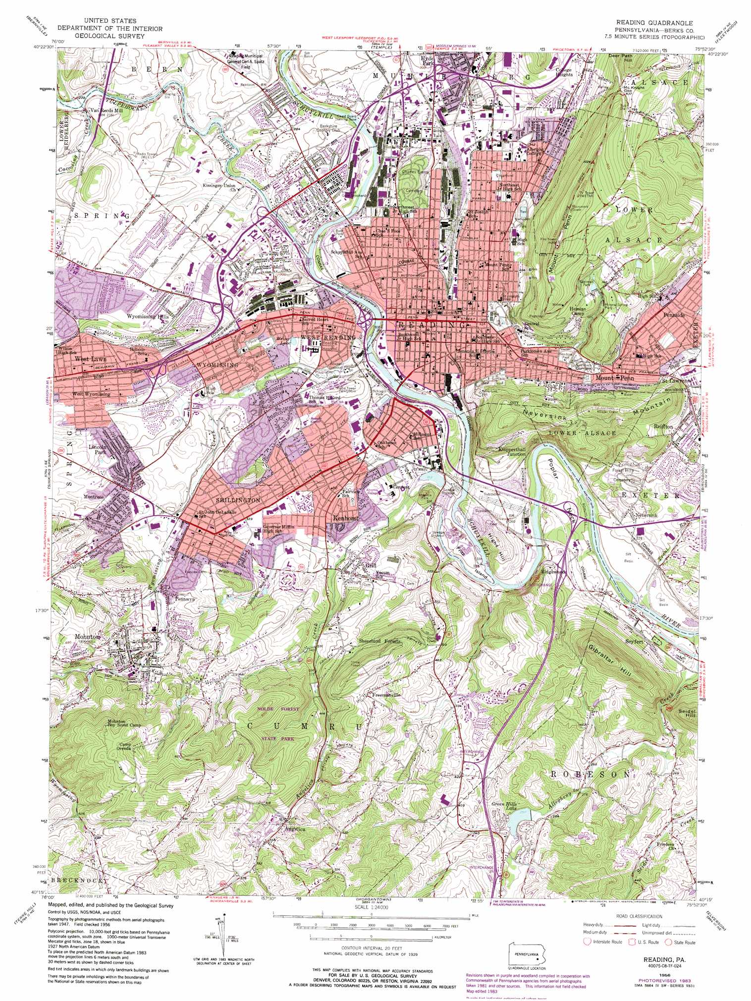
Reading Topo Map Pennsylvania
To zoom in, hover over the map of Reading
USGS Topo Quad 40075c8 - 1:24,000 scale
| Topo Map Name: | Reading |
| USGS Topo Quad ID: | 40075c8 |
| Print Size: | ca. 21 1/4" wide x 27" high |
| Southeast Coordinates: | 40.25° N latitude / 75.875° W longitude |
| Map Center Coordinates: | 40.3125° N latitude / 75.9375° W longitude |
| U.S. State: | PA |
| Filename: | o40075c8.jpg |
| Download Map JPG Image: | Reading topo map 1:24,000 scale |
| Map Type: | Topographic |
| Topo Series: | 7.5´ |
| Map Scale: | 1:24,000 |
| Source of Map Images: | United States Geological Survey (USGS) |
| Alternate Map Versions: |
Reading PA 1956, updated 1957 Download PDF Buy paper map Reading PA 1956, updated 1964 Download PDF Buy paper map Reading PA 1956, updated 1969 Download PDF Buy paper map Reading PA 1956, updated 1977 Download PDF Buy paper map Reading PA 1956, updated 1984 Download PDF Buy paper map Reading PA 1956, updated 1988 Download PDF Buy paper map Reading PA 1956, updated 1988 Download PDF Buy paper map Reading PA 1999, updated 2001 Download PDF Buy paper map Reading PA 2010 Download PDF Buy paper map Reading PA 2013 Download PDF Buy paper map Reading PA 2016 Download PDF Buy paper map |
1:24,000 Topo Quads surrounding Reading
Friedensburg |
Auburn |
Hamburg |
Kutztown |
Topton |
Strausstown |
Bernville |
Temple |
Fleetwood |
Manatawny |
Womelsdorf |
Sinking Spring |
Reading |
Birdsboro |
Boyertown |
Ephrata |
Terre Hill |
Morgantown |
Elverson |
Pottstown |
Leola |
New Holland |
Honey Brook |
Wagontown |
Downingtown |
> Back to 40075a1 at 1:100,000 scale
> Back to 40074a1 at 1:250,000 scale
> Back to U.S. Topo Maps home
Reading topo map: Gazetteer
Reading: Airports
Arnold Airport elevation 90m 295′Penske Heliport elevation 64m 209′
Reading: Areas
Stonecliffe Recreation Area elevation 68m 223′Reading: Bridges
Allegheny Aqueduct elevation 58m 190′Askew Bridge elevation 75m 246′
Bingaman Street Bridge elevation 61m 200′
Buttonwood Street Bridge elevation 75m 246′
Lindbergh Viaduct elevation 145m 475′
Penn Street Bridge elevation 67m 219′
Red Bridge elevation 72m 236′
Schuylkill Avenue Bridge elevation 77m 252′
Spruce Bridge (historical) elevation 64m 209′
Reading: Dams
Angelica Lake Dam elevation 82m 269′Egelman Reservoir Dam elevation 213m 698′
Green Hills Lake Dam elevation 90m 295′
Green Hills Lake Dam elevation 91m 298′
Mirror Pool Dam elevation 76m 249′
Nolde Dam elevation 206m 675′
Number Three Dam elevation 225m 738′
Number Two Dam elevation 218m 715′
Stanford Avenue Stormwater Retention Pond elevation 123m 403′
Tulpehocken Dam elevation 58m 190′
Reading: Flats
Poplar Neck elevation 79m 259′Reading: Gaps
McKnight Gap elevation 246m 807′Reading: Islands
Bushongs Island (historical) elevation 56m 183′Fritz Island elevation 66m 216′
Independence Island (historical) elevation 64m 209′
Reading: Lakes
Weiser Lake elevation 78m 255′Reading: Parks
Allegheny Aqueduct Historical Park elevation 56m 183′Angelica Park elevation 115m 377′
Baer Park elevation 78m 255′
Barbeys Playground elevation 79m 259′
Berkshire Heights Playground elevation 80m 262′
Brookline Playground elevation 85m 278′
Cedar Street Park elevation 88m 288′
Centre Park elevation 100m 328′
City Park elevation 107m 351′
City Park Playground elevation 105m 344′
Colony Park elevation 91m 298′
Colony Park Playground elevation 90m 295′
Crestwood Recreation Area elevation 104m 341′
Dana Memorial Park elevation 70m 229′
Dove Garden elevation 120m 393′
Drenkel Field elevation 285m 935′
Drexelwood Park elevation 105m 344′
E.J. Dives Playground elevation 81m 265′
Egelman Park elevation 222m 728′
Eighth and Amity Playground elevation 88m 288′
Eleventh and Pike Playground elevation 87m 285′
Fountain Park elevation 115m 377′
Front and Schiller Playground elevation 89m 291′
Gene L Shirk Stadium elevation 92m 301′
Glenside Playground elevation 94m 308′
Grings Mill Recreation Area elevation 78m 255′
Hampden Park elevation 147m 482′
Happy Hollow Playground elevation 80m 262′
Heritage Park elevation 64m 209′
Hillside Playground elevation 160m 524′
Keffer Park elevation 77m 252′
Kenhorst Playground elevation 101m 331′
Ketchner Field elevation 94m 308′
Lauers Run Park elevation 85m 278′
Mineral Spring Park elevation 226m 741′
Mohnton Memorial Park elevation 115m 377′
Montrose Manor Playground elevation 127m 416′
Mount Penn Reserve elevation 288m 944′
Neversink Playground elevation 127m 416′
Nolde Forest State Park elevation 219m 718′
Oakbrook Housing Park elevation 91m 298′
Owls Field elevation 106m 347′
Pendora Park elevation 123m 403′
Pennwyn Playground elevation 113m 370′
Pioneer Grove elevation 76m 249′
Reading Greenway elevation 63m 206′
Reading Iron Playground elevation 75m 246′
Reading Police Memorial elevation 119m 390′
Red Caboose Park elevation 106m 347′
Riverfront Park elevation 65m 213′
Schlegel Park elevation 82m 269′
Science Field elevation 106m 347′
Shillington Park elevation 111m 364′
Tenth and South Playground elevation 108m 354′
Third and Spring Playground elevation 111m 364′
Third and Spruce Recreation Area elevation 61m 200′
Trout Run Sports Complex elevation 66m 216′
Tulpehocken Creek Valley Park elevation 89m 291′
West Reading Playground elevation 77m 252′
Windsor and Ritter Playground elevation 90m 295′
Wyomissing Area Athletic Field elevation 80m 262′
Wyomissing Hills Memorial Park elevation 115m 377′
Wyomissing Park elevation 83m 272′
Yarnell Park elevation 95m 311′
Reading: Populated Places
Angelica elevation 148m 485′Berkshire Heights elevation 76m 249′
Beverly Heights elevation 115m 377′
Birdland elevation 105m 344′
Brookline elevation 89m 291′
Clover Park elevation 95m 311′
College Heights elevation 140m 459′
Crestwood elevation 114m 374′
Crestwood South elevation 75m 246′
Deerfield Village elevation 106m 347′
East Reading elevation 111m 364′
Flying Hills elevation 125m 410′
Freemanville elevation 174m 570′
Glenside elevation 92m 301′
Greenfield Manor elevation 85m 278′
Grill elevation 103m 337′
Hampden Heights elevation 124m 406′
Highlands at Wyomissing elevation 104m 341′
Kenhorst elevation 106m 347′
Klapperthall Junction elevation 95m 311′
Lincoln Park elevation 93m 305′
Longview Estates elevation 122m 400′
Mifflin Park elevation 104m 341′
Millmont elevation 84m 275′
Mohnton elevation 151m 495′
Mohnton Lawn elevation 134m 439′
Montrose elevation 115m 377′
Montrose Manor elevation 119m 390′
Mount Penn elevation 159m 521′
Neversink elevation 93m 305′
Northmont elevation 85m 278′
Oakbrook elevation 70m 229′
Oakbrook Terrace elevation 93m 305′
Overbrook elevation 153m 501′
Park Manor elevation 120m 393′
Pennside elevation 103m 337′
Pennwyn elevation 114m 374′
Reading elevation 93m 305′
Ridge Park elevation 95m 311′
Ridgewood elevation 74m 242′
Seyfert elevation 63m 206′
Shillington elevation 107m 351′
Spring Ridge elevation 133m 436′
Springmont elevation 111m 364′
Stone Ridge elevation 109m 357′
Thomas Gardens elevation 109m 357′
Van Reeds Mill elevation 71m 232′
Welsh Woods elevation 130m 426′
West Lawn elevation 117m 383′
West Reading elevation 98m 321′
West Wyomissing elevation 110m 360′
Woodgate elevation 84m 275′
Wyomissing elevation 96m 314′
Wyomissing Hills elevation 111m 364′
Wyomissing Park elevation 101m 331′
Reading: Post Offices
Mohnton Post Office elevation 112m 367′Reading Post Office elevation 106m 347′
Reading Post Office-Downtown elevation 86m 282′
Reading Post Office-North Carrier Annex elevation 74m 242′
Wyomissing Post Office elevation 92m 301′
Reading: Reservoirs
Angelica Lake elevation 82m 269′Egelman Basin elevation 225m 738′
Egelman Lake elevation 212m 695′
Flying Hills Swimming Pool elevation 99m 324′
Green Hills Lake elevation 95m 311′
Hillside Swimming Pool elevation 161m 528′
Kengrill Pool elevation 85m 278′
Lake Valmont (historical) elevation 119m 390′
Mohnton Family Swim Association Pool elevation 145m 475′
Neversink Reservoir elevation 143m 469′
Northwest Swimming Pool elevation 77m 252′
Schlegel Park Pool elevation 70m 229′
Shillington Swimming Pool elevation 107m 351′
Stone House Pond elevation 79m 259′
West Reading Pool elevation 76m 249′
Wyomissing Borough Pool elevation 84m 275′
Wyomissing Hills Swimming Association Pool elevation 115m 377′
Reading: Streams
Allegheny Creek elevation 49m 160′Angelica Creek elevation 70m 229′
Bernhart Creek elevation 66m 216′
Cacoosing Creek elevation 73m 239′
Trout Run elevation 51m 167′
Tulpehocken Creek elevation 63m 206′
Wyomissing Creek elevation 67m 219′
Reading: Summits
Black Bear Hill elevation 160m 524′Dengler Hill elevation 218m 715′
Gibraltar Hill elevation 283m 928′
Highs Hill elevation 114m 374′
Mount Penn elevation 334m 1095′
Neversink Mountain elevation 268m 879′
Reading: Trails
Exeter Scenic River Trail elevation 55m 180′Thun Trail elevation 78m 255′
Wyomissing Creek Trail elevation 78m 255′
Reading digital topo map on disk
Buy this Reading topo map showing relief, roads, GPS coordinates and other geographical features, as a high-resolution digital map file on DVD:
Atlantic Coast (NY, NJ, PA, DE, MD, VA, NC)
Buy digital topo maps: Atlantic Coast (NY, NJ, PA, DE, MD, VA, NC)
 map DVD")