Hellertown Topo Map Pennsylvania
To zoom in, hover over the map of Hellertown
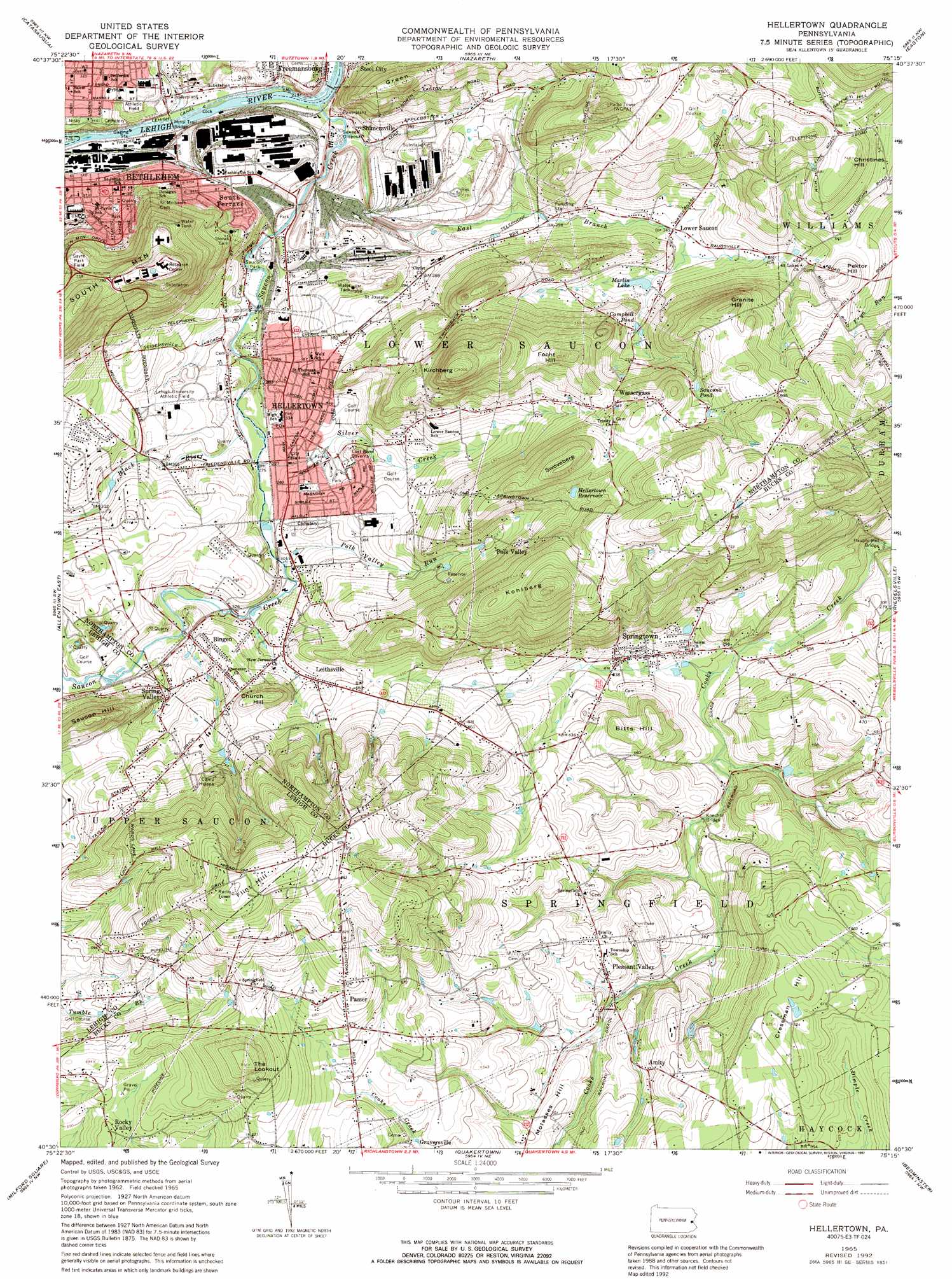
USGS Topo Quad 40075e3 - 1:24,000 scale
| Topo Map Name: | Hellertown |
| USGS Topo Quad ID: | 40075e3 |
| Print Size: | ca. 21 1/4" wide x 27" high |
| Southeast Coordinates: | 40.5° N latitude / 75.25° W longitude |
| Map Center Coordinates: | 40.5625° N latitude / 75.3125° W longitude |
| U.S. State: | PA |
| Filename: | o40075e3.jpg |
| Download Map JPG Image: | Hellertown topo map 1:24,000 scale |
| Map Type: | Topographic |
| Topo Series: | 7.5´ |
| Map Scale: | 1:24,000 |
| Source of Map Images: | United States Geological Survey (USGS) |
| Alternate Map Versions: |
Hellertown PA 1965, updated 1967 Download PDF Buy paper map Hellertown PA 1965, updated 1972 Download PDF Buy paper map Hellertown PA 1965, updated 1992 Download PDF Buy paper map Hellertown PA 1965, updated 1992 Download PDF Buy paper map Hellertown PA 1999, updated 2001 Download PDF Buy paper map Hellertown PA 2010 Download PDF Buy paper map Hellertown PA 2013 Download PDF Buy paper map Hellertown PA 2016 Download PDF Buy paper map |
1:24,000 Topo Quads surrounding Hellertown
Palmerton |
Kunkletown |
Wind Gap |
Bangor |
Belvidere |
Cementon |
Catasauqua |
Nazareth |
Easton |
Bloomsbury |
Allentown West |
Allentown East |
Hellertown |
Riegelsville |
Frenchtown |
East Greenville |
Milford Square |
Quakertown |
Bedminster |
Lumberville |
Sassamansville |
Perkiomenville |
Telford |
Doylestown |
Buckingham |
> Back to 40075e1 at 1:100,000 scale
> Back to 40074a1 at 1:250,000 scale
> Back to U.S. Topo Maps home
Hellertown topo map: Gazetteer
Hellertown: Airports
Bethlehem Landing Field elevation 106m 347′Hellertown: Bridges
Knechts Bridge elevation 98m 321′Minsi Trail Bridge elevation 62m 203′
Hellertown: Dams
Kulp Dam elevation 82m 269′Number Two Dam elevation 191m 626′
Putchat Dam elevation 135m 442′
Hellertown: Gaps
Saucon Gap elevation 71m 232′Hellertown: Lakes
Campbell Pond elevation 126m 413′Marlin Lake elevation 111m 364′
Saucona Pond elevation 192m 629′
Hellertown: Parks
Hellertown Park elevation 106m 347′Lehigh University Athletic Field elevation 95m 311′
Saucon Park elevation 74m 242′
Sayre Park Field elevation 219m 718′
Hellertown: Populated Places
Amity elevation 146m 479′Bingen elevation 120m 393′
Didier elevation 73m 239′
Gruversville elevation 168m 551′
Hellertown elevation 88m 288′
Iron Hill (historical) elevation 88m 288′
Kirchberg elevation 306m 1003′
Leithsville elevation 125m 410′
Lower Saucon elevation 103m 337′
Marlin Hills elevation 152m 498′
Northampton Heights elevation 88m 288′
Passer elevation 221m 725′
Pleasant Valley elevation 146m 479′
Polk Valley elevation 189m 620′
Rocky Valley elevation 200m 656′
Saucon elevation 64m 209′
Saucon Valley Terrace elevation 126m 413′
Saucona elevation 114m 374′
Shimersville elevation 68m 223′
South Bethlehem elevation 87m 285′
South Terrace elevation 112m 367′
Specktown elevation 140m 459′
Spring Valley elevation 114m 374′
Springtown elevation 106m 347′
Wassergass elevation 198m 649′
Hellertown: Post Offices
Pleasent Valley Post Office (historical) elevation 146m 479′Hellertown: Reservoirs
Hellertown Reservoir elevation 191m 626′Hellertown: Streams
Black River elevation 78m 255′East Branch Saucon Creek elevation 64m 209′
Eileen Run elevation 99m 324′
Monocacy Creek elevation 63m 206′
Polk Valley Run elevation 89m 291′
Saucon Creek elevation 62m 203′
Silver Creek elevation 88m 288′
Silver Creek elevation 84m 275′
Hellertown: Summits
Bitts Hill elevation 167m 547′Christines Hill elevation 226m 741′
Church Hill elevation 177m 580′
Cressman Hill elevation 205m 672′
Flint Hill elevation 308m 1010′
Focht Hill elevation 244m 800′
Granite Hill elevation 238m 780′
Green Hill elevation 205m 672′
Kirchberg elevation 305m 1000′
Kohlberg elevation 294m 964′
Molasses Hill elevation 152m 498′
Pektor Hill elevation 184m 603′
Saucon Hill elevation 204m 669′
Swoveberg elevation 257m 843′
The Lookout elevation 277m 908′
Hellertown digital topo map on disk
Buy this Hellertown topo map showing relief, roads, GPS coordinates and other geographical features, as a high-resolution digital map file on DVD:
Atlantic Coast (NY, NJ, PA, DE, MD, VA, NC)
Buy digital topo maps: Atlantic Coast (NY, NJ, PA, DE, MD, VA, NC)
 map DVD")