Bloomsbury Topo Map New Jersey
To zoom in, hover over the map of Bloomsbury
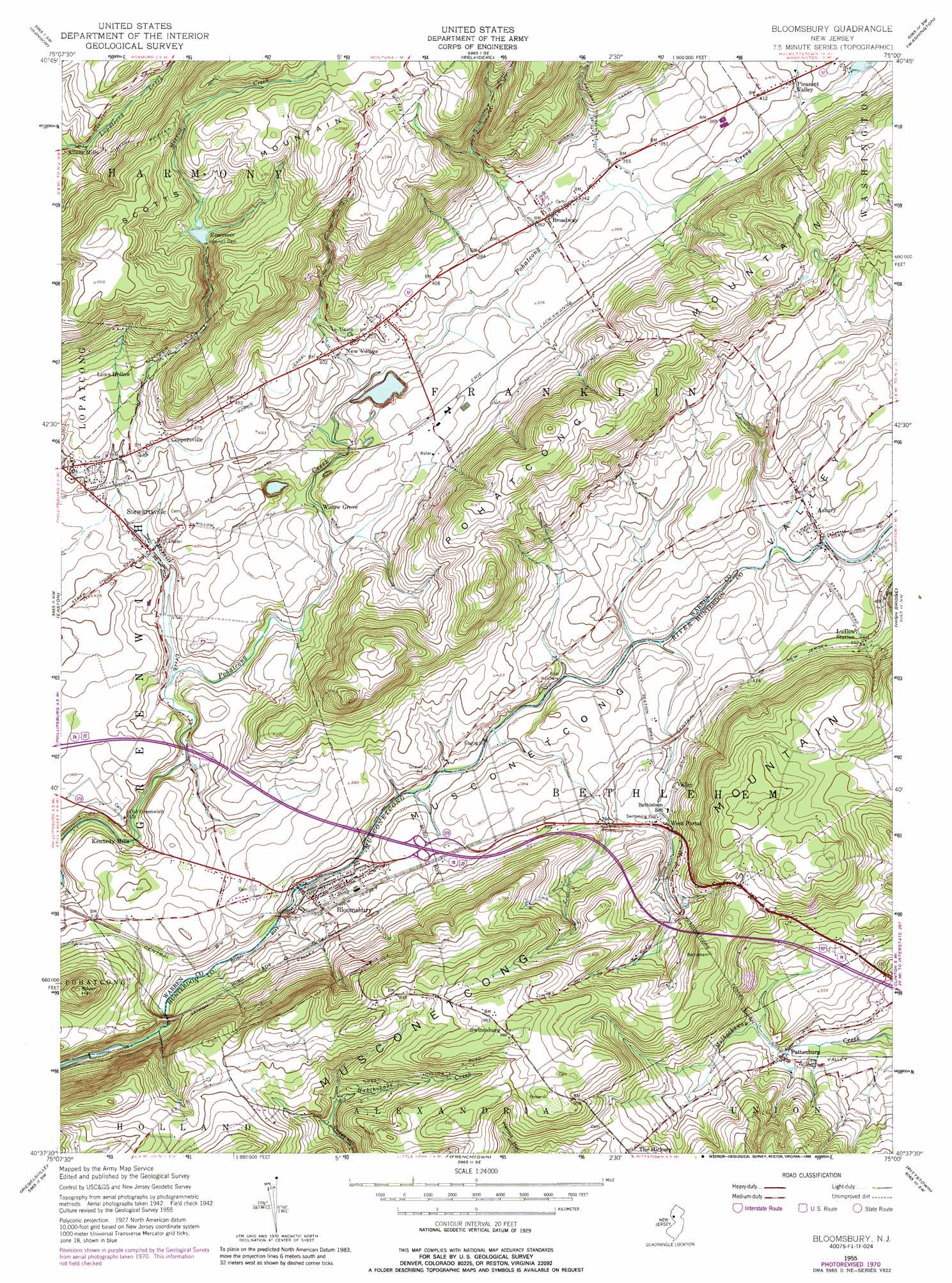
USGS Topo Quad 40075f1 - 1:24,000 scale
| Topo Map Name: | Bloomsbury |
| USGS Topo Quad ID: | 40075f1 |
| Print Size: | ca. 21 1/4" wide x 27" high |
| Southeast Coordinates: | 40.625° N latitude / 75° W longitude |
| Map Center Coordinates: | 40.6875° N latitude / 75.0625° W longitude |
| U.S. State: | NJ |
| Filename: | o40075f1.jpg |
| Download Map JPG Image: | Bloomsbury topo map 1:24,000 scale |
| Map Type: | Topographic |
| Topo Series: | 7.5´ |
| Map Scale: | 1:24,000 |
| Source of Map Images: | United States Geological Survey (USGS) |
| Alternate Map Versions: |
Bloomsbury NJ 1955, updated 1956 Download PDF Buy paper map Bloomsbury NJ 1955, updated 1965 Download PDF Buy paper map Bloomsbury NJ 1955, updated 1972 Download PDF Buy paper map Bloomsbury NJ 1955, updated 1988 Download PDF Buy paper map Bloomsbury NJ 2011 Download PDF Buy paper map Bloomsbury NJ 2014 Download PDF Buy paper map Bloomsbury NJ 2016 Download PDF Buy paper map |
1:24,000 Topo Quads surrounding Bloomsbury
Saylorsburg |
Stroudsburg |
Portland |
Blairstown |
Tranquility |
Wind Gap |
Bangor |
Belvidere |
Washington |
Hackettstown |
Nazareth |
Easton |
Bloomsbury |
High Bridge |
Califon |
Hellertown |
Riegelsville |
Frenchtown |
Pittstown |
Flemington |
Quakertown |
Bedminster |
Lumberville |
Stockton |
Hopewell |
> Back to 40075e1 at 1:100,000 scale
> Back to 40074a1 at 1:250,000 scale
> Back to U.S. Topo Maps home
Bloomsbury topo map: Gazetteer
Bloomsbury: Airports
Jugtown Mountain Airport elevation 234m 767′Parker Airport elevation 147m 482′
View Finder Balloonport elevation 110m 360′
Bloomsbury: Crossings
Pennsylvania Turnpike Interchange 3 elevation 108m 354′Bloomsbury: Dams
Ingersoll Dam elevation 220m 721′Pleasant Valley Mill Dam elevation 113m 370′
Bloomsbury: Populated Places
Allens Mills elevation 182m 597′Asbury elevation 103m 337′
Bloomsbury elevation 95m 311′
Broadway elevation 110m 360′
Coopersville elevation 137m 449′
Kennedy Mills elevation 69m 226′
Lows Hollow elevation 150m 492′
New Village elevation 115m 377′
Pattenburg elevation 139m 456′
Stewartsville elevation 95m 311′
Swinesburg elevation 301m 987′
Valley elevation 129m 423′
West Portal elevation 137m 449′
Willow Grove elevation 89m 291′
Bloomsbury: Reservoirs
Ingersoll Reservoir elevation 220m 721′Bloomsbury: Streams
Brass Castle Creek elevation 113m 370′Merrill Creek elevation 76m 249′
Bloomsbury: Summits
Musconetcong Mountain elevation 289m 948′Pohatcong Mountain elevation 264m 866′
Scotts Mountain elevation 331m 1085′
Silver Hill elevation 220m 721′
Bloomsbury: Valleys
Musconetcong Valley elevation 110m 360′Bloomsbury digital topo map on disk
Buy this Bloomsbury topo map showing relief, roads, GPS coordinates and other geographical features, as a high-resolution digital map file on DVD:
Atlantic Coast (NY, NJ, PA, DE, MD, VA, NC)
Buy digital topo maps: Atlantic Coast (NY, NJ, PA, DE, MD, VA, NC)
 map DVD")